IONA BEGINS TO WEAKEN WELL TO THE SOUTH OF HAWAII
According to the NHC advisory number 12

")
By PDC’s Senior Weather
Specialist Glenn James

The Pacific Disaster Center’s (PDC Global) Tuesday, July 29, 2025, Tropical Cyclone Activity Report…for the Pacific Ocean, the Indian Ocean, and adjacent Seas
Current Tropical Cyclones:
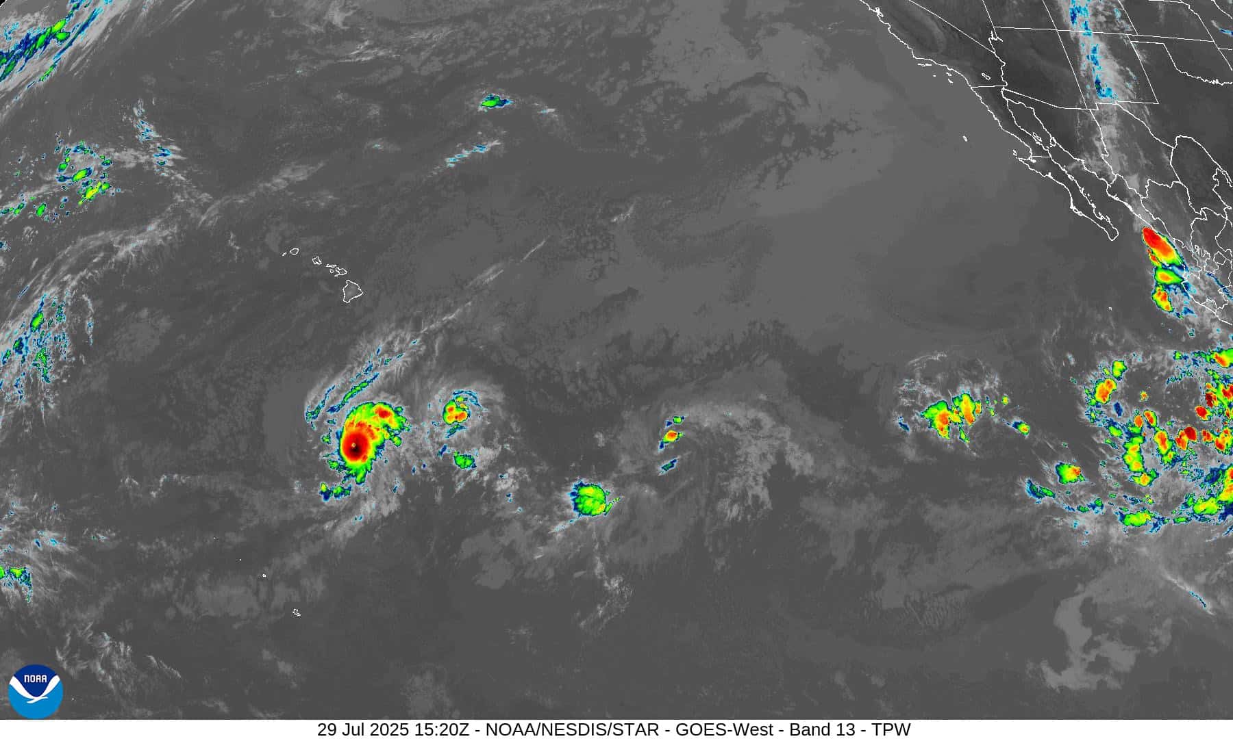
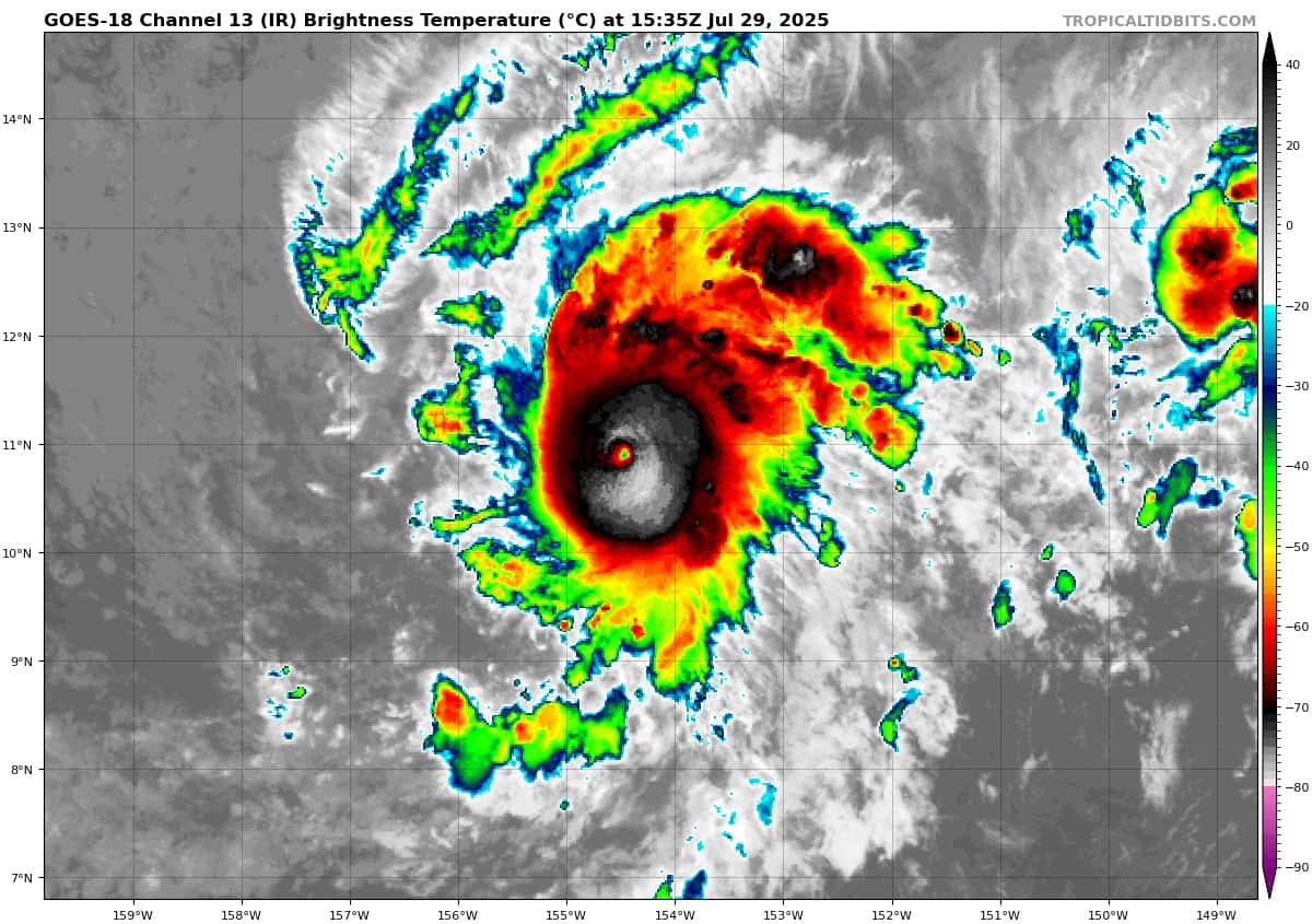
Tropical Cyclone 01C (Iona)…is located about 715 miles south of Honolulu, Hawaii
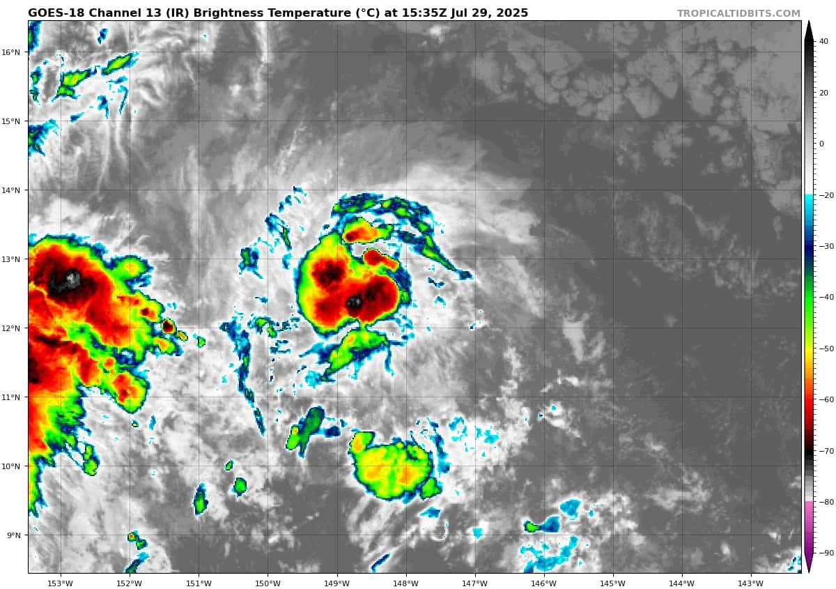
Tropical Cyclone 02C (Keli)…is located about 700 miles southeast of Honolulu, Hawaii
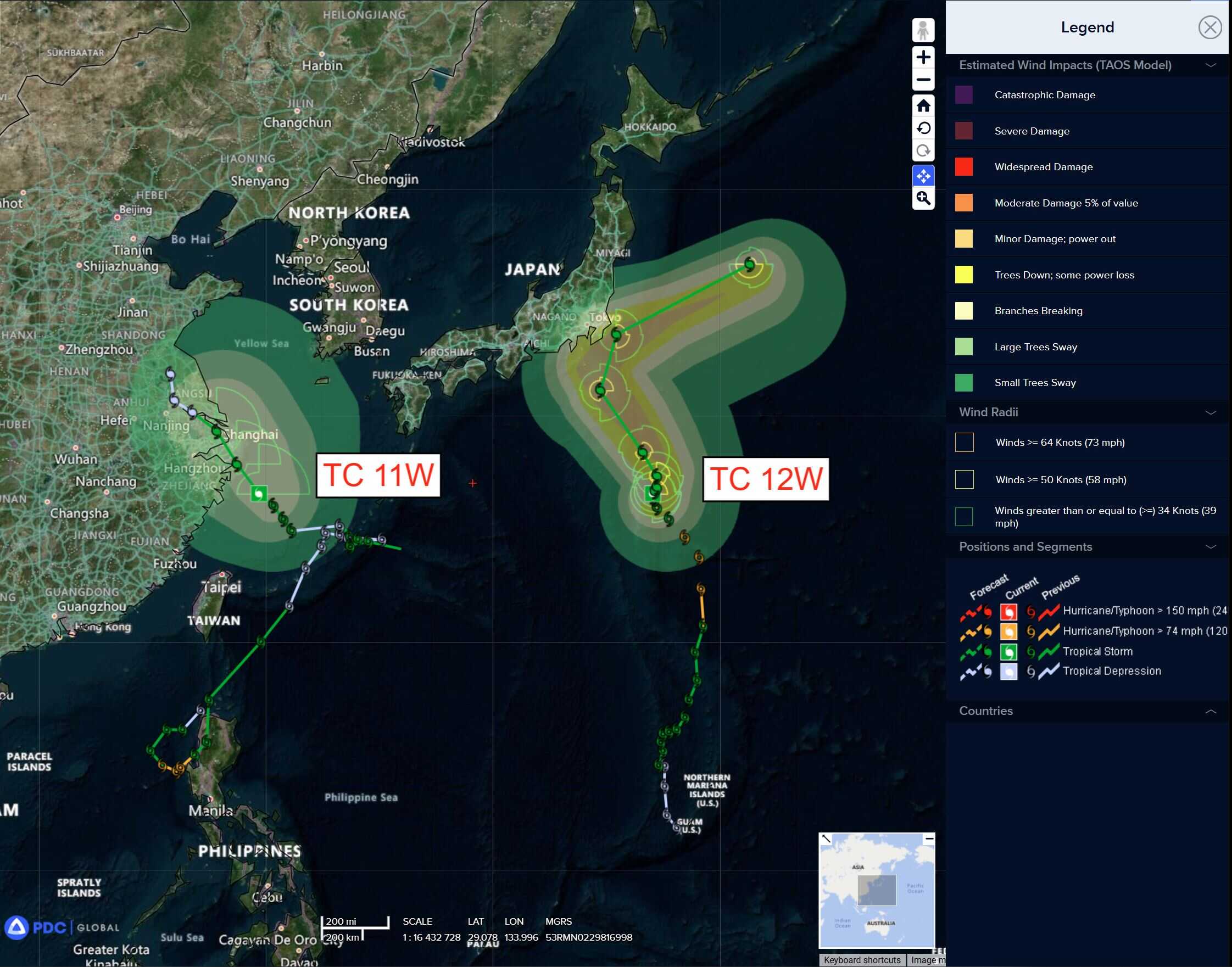
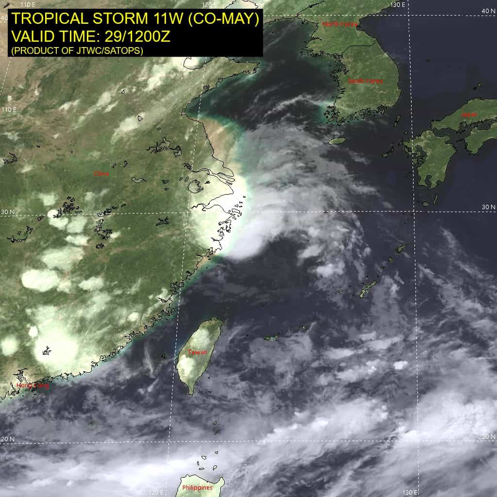
Tropical Cyclone 11W (Co-may)…is located 83 NM south-southeast of Shanghai, China
Tropical Cyclone 12W (Krosa)…is located 426 NM south-southeast of Yokosuka, Japan
Northeast Pacific Ocean: There are no Tropical Cyclones
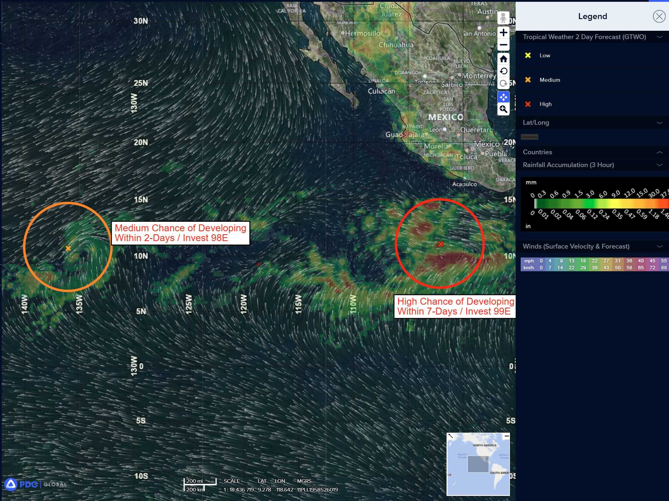
Western East Pacific:
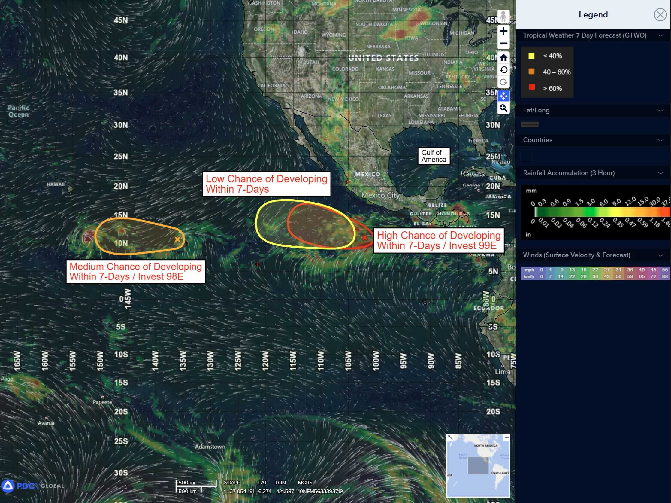
Invest 98E
>>>
Showers and thunderstorms associated with an area of low pressure located around 1150 miles east-southeast of the Hawaiian Islands remain limited and have changed little since this morning. However, if persistent showers and thunderstorms re-develop during the next day or so, a short-lived tropical depression could still form. The system will enter the Central Pacific basin shortly.
* Formation chance through 48 hours…medium…60 percent
* Formation chance through 7 days…medium…60 percent
South of Southwestern Mexico:
Invest 99E
>>> A trough of low pressure located several hundred miles southwest of the southwestern coast of Mexico is producing a large area of disorganized showers and thunderstorms. Environmental conditions appear conducive for development, and a tropical depression is likely to form during the next day or two while the system moves west-northwestward around 15 mph, remaining well offshore of the southwestern coast of Mexico.
* Formation chance through 48 hours…high…80 percent
* Formation chance through 7 days…high…90 percent
Central East Pacific:
>>> An area of low pressure is forecast to develop well south of southern or southwestern Mexico late this week. Environmental conditions appear conducive for some gradual development of this system and a tropical depression could develop over the weekend or early next week as the system moves west-northwestward at 10 to 15 mph.
* Formation chance through 48 hours…low…near 0 percent.
* Formation chance through 7 days…medium…60 percent
Central Pacific Ocean:
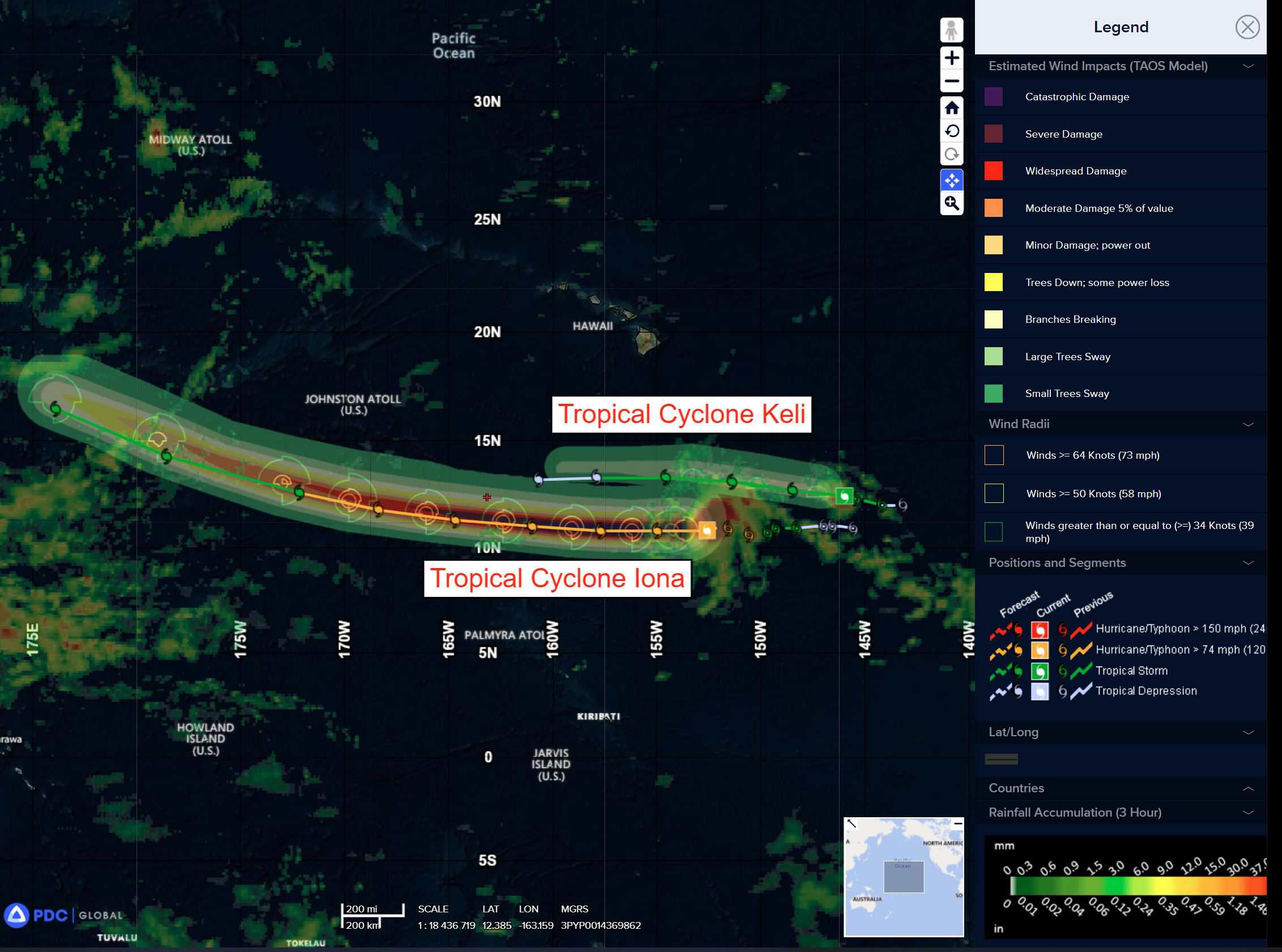
Tropical Cyclone 01C (Iona)
IONA BEGINS TO WEAKEN WELL TO THE SOUTH OF HAWAII
According to the NHC advisory number 12
Iona is moving toward the west near 17 mph (28 km/h). This general motion with some increase in forward speed is expected during the next couple of days. Maximum sustained winds are near 115 mph (185 km/h) with higher gusts. Iona is a category 3 hurricane on the Saffir-Simpson Hurricane Wind Scale. Rapid weakening is expected tonight and Wednesday, followed by more gradual weakening Wednesday night and Thursday. Hurricane-force winds extend outward up to 25 miles (35 km) from the center and tropical-storm-force winds extend outward up to 90 miles (150 km).
Tropical Cyclone 02C (Keli)
KELI MOVING QUICKLY WESTWARD WHILE MAINTAINING ITS INTENSITY
According to the NHC advisory number 7
Keli is moving toward the west near 18 mph (30 km/h) and a westward to west-northwestward motion at a faster forward speed is expected during the next day or so. Maximum sustained winds remain near 40 mph (65 km/h) with higher gusts. Little change in strength is forecast through tonight, but Keli is expected to weaken into a depression on Wednesday and dissipate by Thursday. . Tropical-storm-force winds extend outward up to 35 miles (55 km) from the center.
Western Pacific, Indian Ocean, and adjacent Seas:
Western Pacific
Tropical Cyclone 11W (Co-may)
According to the JTWC warning number 29 sustained winds are 40 knots with gusts to near 50 knots
Animated proxy visible (proxyvis) satellite imagery depicts a decoupled system, with deep convection forming a mesoscale convective system (mcs) north of the partially exposed low level circulation center (llcc). The vortex is complex, with multiple spinners seen shooting out from under the mcs over the past few hours, with a large one currently moving eastward into the clear air southeast of the mcs. The llcc is assumed to be a centroid feature, around which the visible spinners are rotating. radar data from China is picking up on a mid-level rotation in the center of the mcs, but actual llcc is too shallow for the radar to detect.
A surface observation from Dachen Dao shows winds from the NNW at 19 knots, having backed over the past few hours from northeasterly, suggestive of the llcc being at least at the same latitude or slightly north. A microwave image revealed the complex structure of the low-level vortex, with multiple areas of rotation present south of deep convective bands.
Environmental conditions are marginally unfavorable, with warm ssts and moderate poleward outflow offset by moderate mid-level southerly shear (as indicated by model-derived soundings).
Tropical storm 11W is forecast to continue tracking northwestward along the southwestern side of the str through the majority of the forecast period. TS 11W is forecast to skirt the offshore islands southeast of Shanghai around 12 hours, then cross Hangzhou Bay and make landfall in the vicinity of Shanghai prior to 24 hours. Once the system makes landfall, it is forecast to continue tracking northwestward through 48 hours. as the system dissipates by 72 hours, the remnant vortex will turn northeastward near Gaoyou Lake.
Both the timing and the location of landfall may differ significantly if the low-level spinner currently pushing eastward turns out to be the actual center of the tropical storm. If this is the case, the llcc will likely perform a counter-clockwise loop, then resume its northwestward track, but arrive near Shanghai approximately 6-12 hours later.
The system is unlikely to intensify prior to landfall due to the decoupled structure of the vortex and landfall intensity is currently expected to be 40 knots. Once the system moves ashore, it will rapidly weaken to the west of Shanghai, meeting its end near Gaoyou Lake no later than 72 hours.
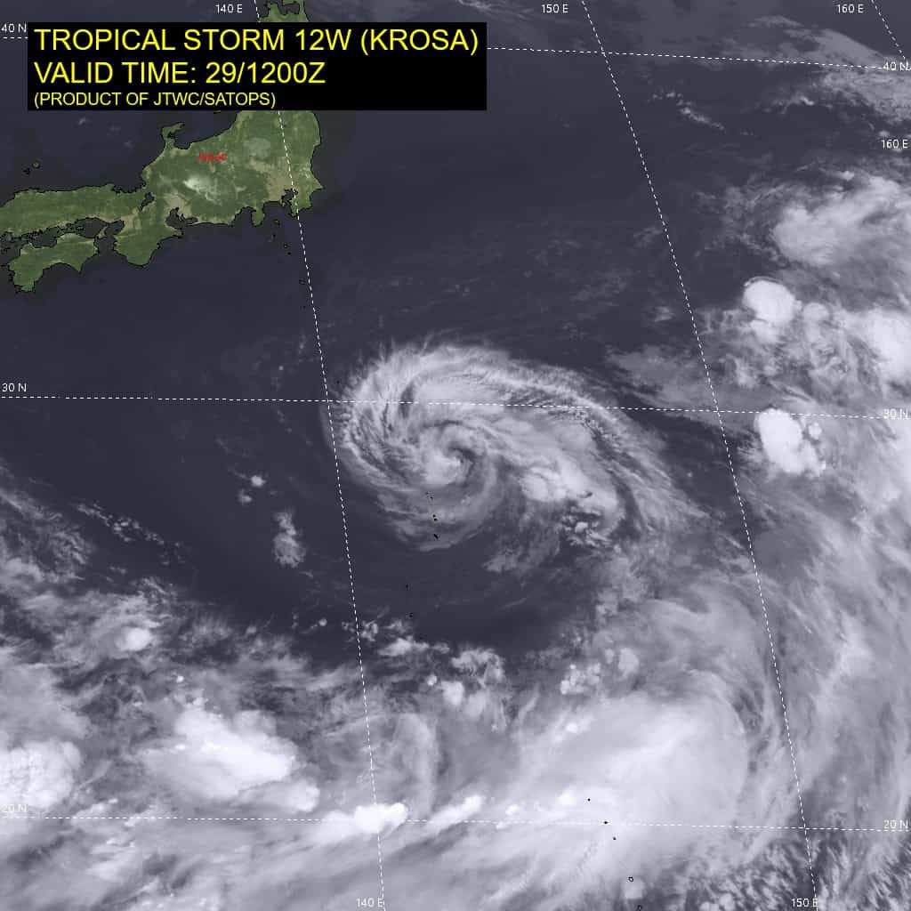
Tropical Cyclone 12W (Krosa)
According to the JTWC warning number 26 sustained winds are 40 knots with gusts to near 50 knots
Animated proxy visible (proxyvis) satellite imagery depicts a well-defined low level circulation center (llcc), with bands of shallow convection wrapping into a small center. The system has been wobbling around rather aimlessly inside the weak steering pattern and remained for the most part quasi-stationary over the past six hours. This has induced significant oceanic upwelling, reducing ssts under the system, depriving it of energy.
An ascat-b pass revealed a fairly symmetrical wind field, with gale-force winds present around most of the llcc, with some 45 knot winds in the northeast quadrant. The ultra-high resolution (uhr) version of the scatterometer pass revealed some 50 knot winds to the northeast.
Environmental conditions are marginal, with low vws offset by oceanic upwelling and the presence of the an upper-level cyclone over top of the system, limiting available outflow aloft, as well as dry air intrusion into the core of the system.
Tropical storm 12W will remain stuck between the two ridges competing for steering dominance and is expected to remain quasi-stationary for the next 24 hours. After 24 hours, the system should begin to move northward a bit as the str currently to the southeast shifts northward a bit and gives it one
last push.
The latest runs of both the ecmwf and gfs models have backed off on the strength of the ridging over Japan, while at the same time building the str to the east and expanding it northward, with the gfs being the most aggressive in doing this. Hence, after 36 hours, TS 12W is forecast to move quickly out of its quasi-stationary area and track towards the northwest along the southwestern side of this building ridge to the east.
The question remains, how strong will the ridge get and how far west will TS 12W track.The gfs shows the strongest turn west-northwest, while the ecmwf indicates a more northwest track. By 72 hours, the system reaches an inflection point, with all of the track guidance indicating it will take a sharp right turn, towards the northeast, after this time as the ridge to the east slides southwest and TS 12W rounds the ridge axis while at the same time being picked up by a minor shortwave trof over Japan. The question again is where this turn will occur.
The gfs depicts the furthest southwest starting point and the sharpest turn, keeping the system well offshore. The ecmwf meanwhile makes it closer to Honshu, or even making landfall briefly, before making a shallower turn northeastward. Regardless of the starting point, by 120 hours, the system will be racing off the northeast into the open western Pacific along the tight gradient on the northwest side of the str to the southeast.
In terms of intensity, the system is forecast to weaken as it remains quasi-stationary and suffers under persistent dry air intrusion and oceanic upwelling. By 48 hours, as the system moves away from its current position, sst’s will increase sharply, and development of a tutt-cell to the west will enhance upper-level outflow, allowing the system to intensify as it approaches Honshu. The system will rapidly weaken after 96 hours due
to decreasing ssts and steadily increasing shear.
>>> There’s an area of disturbed weather being referred to as Invest 92W, which is located approximately 579 NM east of Tokyo, Japan
The system is currently classified as a subtropical cyclone, generally characterized as having both tropical and mid-latitude cyclone features. Animated enhanced infrared satellite imagery depicts a weak llcc on the southeastern flank of an upper-level trough, currently fully exposed and being sheared from the northwest, with a deep convective cloud system on the southeast side.
Environmental analysis reveals unfavorable conditions for tropical transition defined by a deep layer of dry air being advected over the low level circulation and high (30 knots) westerly vertical wind shear associated with an approaching
long wave trough. Furthermore, the system is fast approaching waters not conducive for tropical development.
Global deterministic models are in agreement on a northeastward track with an asymmetric wind field over the next 24 to 48 hours.
Maximum sustained surface winds are estimated at 25 to 30 knots.
The potential for the development of a significant tropical cyclone within the next 24 hours is low.