
")
Current Snapshot
For all the latest updates visit: DisasterAWARE

1800×1080

2
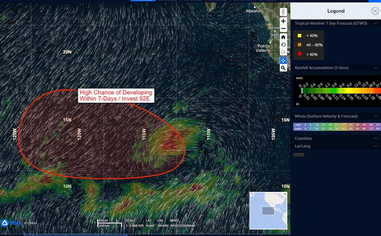
92e7
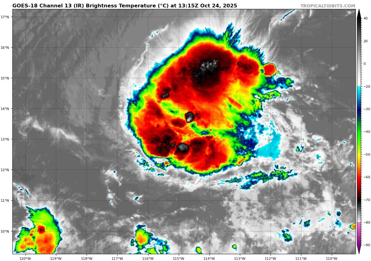
goes18_ir_92E_202510241315_lat13.2-lon-114.3

92E_tracks_latest
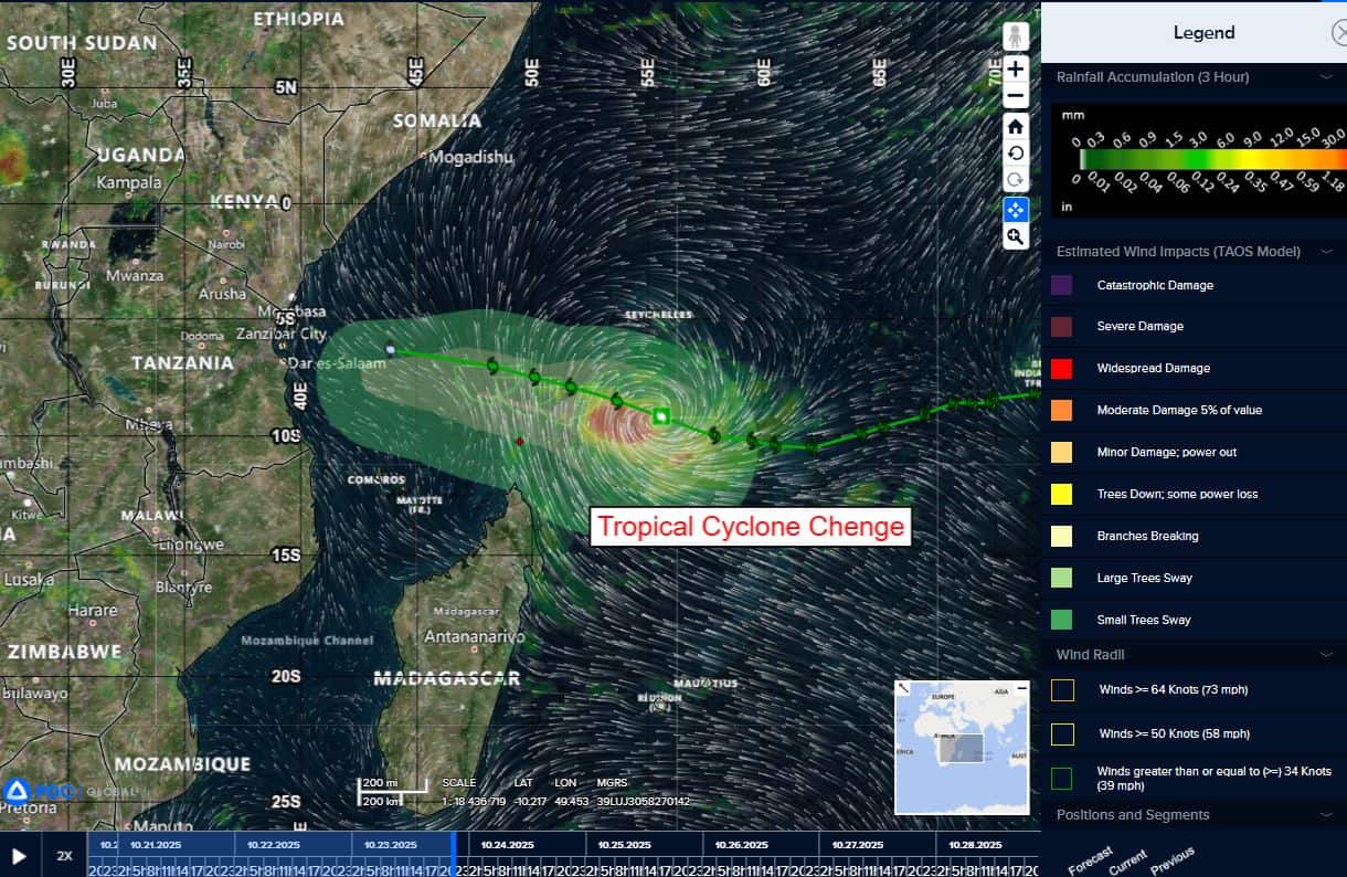
chenge
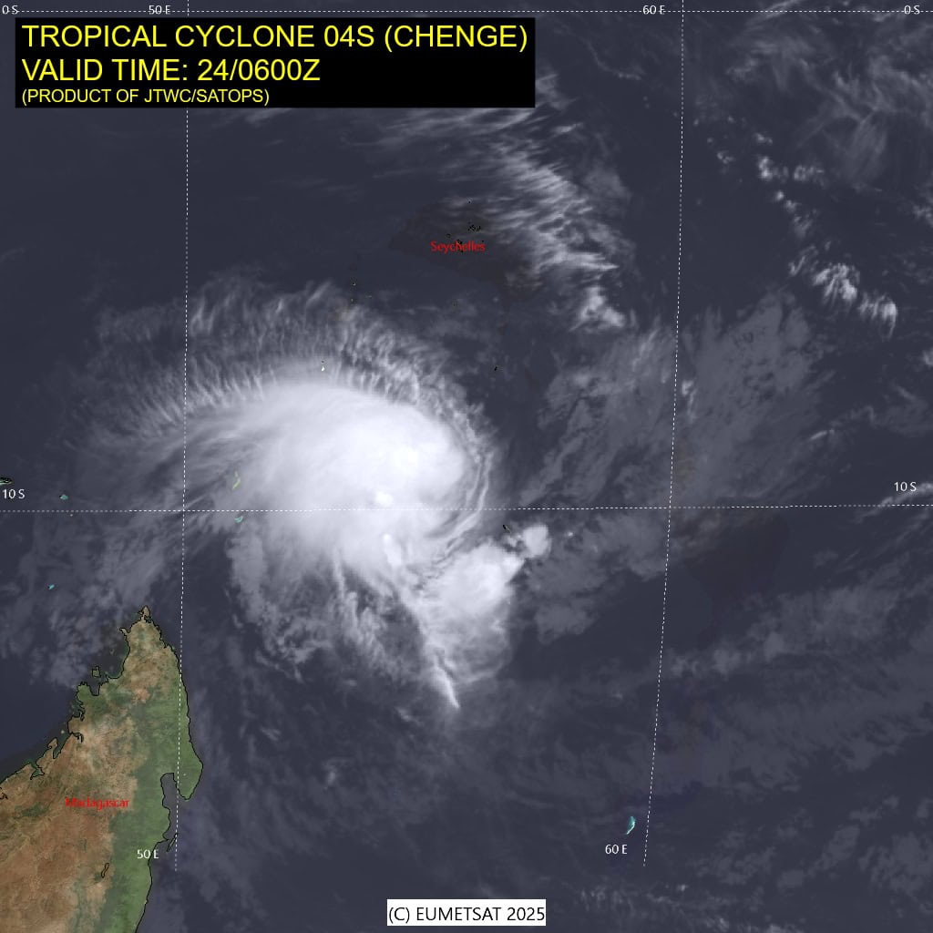
04S_240600sair
04S_tracks_latest
95s
meteosat9_ir_95S_202510241306_lat-8.7-lon79.6
95S_tracks_latest

92a
meteosat9_ir_92A_202510241306_lat17.1-lon71.5
92A_tracks_latest

94b
meteosat9_ir_94B_202510241306_lat10.7-lon89.0

94B_tracks_latest
By PDC’s Senior Weather
Specialist Glenn James

The Pacific Disaster Center’s (PDC Global) Friday, October 24, 2025, Tropical Cyclone Activity Report…for the Pacific Ocean, the Indian Ocean, and adjacent Seas
Current Tropical Cyclones:
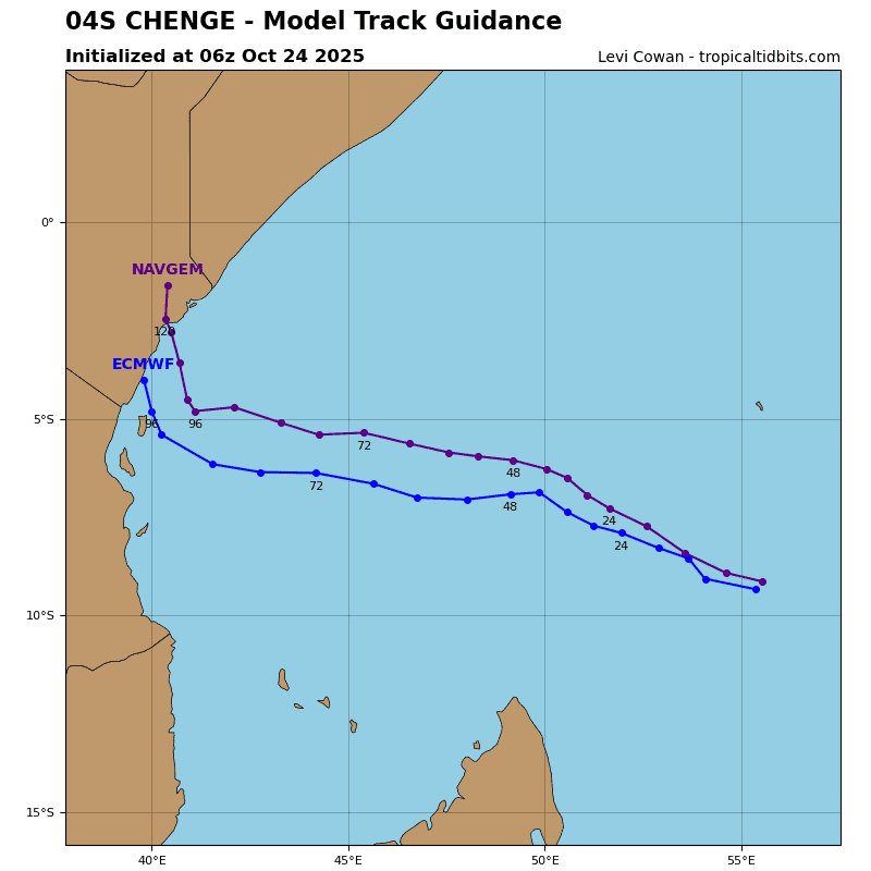
Tropical Cyclone 04S (Chenge)…is located approximately 702 NM north-northeast of Antananarivo, Madagascar
Northeast Pacific Ocean:
Tropical Cyclone Melissa…is located about 225 miles southwest of Port Au Prince, Haiti
NOAA AND AIR FORCE RESERVE HURRICANE HUNTERS REPORT LITTLE CHANGE IN MELISSA’S STRENGTH DURING THE PAST FEW HOURS…LIFE-THREATENING AND CATASTROPHIC FLASH FLOODING AND LANDSLIDES EXPECTED IN PORTIONS OF SOUTHERN HISPANIOLA AND JAMAICA THROUGH THE WEEKEND
According to the NHC advisory number 14A
A turn to the west is forecast on Saturday and this general motion is expected to continue through Monday. A turn to the north and northeast is forecast on Tuesday and Wednesday. On the forecast track, the center of Melissa is expected to move near or over Jamaica early next week and could be near or over eastern Cuba by the middle of next week.
Reports from NOAA and Air Force Reserve Hurricane Hunter aircraft indicate that maximum sustained winds are near 65 mph with higher gusts. Rapid intensification is forecast over the next several days, and Melissa is forecast to become a hurricane tomorrow and a major hurricane by Sunday.
Tropical-storm-force winds extend outward up to 140 miles from the center. The minimum central pressure reported by the Hurricane Hunter aircraft is 993 mb (29.33 inches).
Central Pacific Ocean: There are no Tropical Cyclones
Tropical cyclone formation is not expected during the next 7 days.
Western Pacific, Indian Ocean, and adjacent Seas:
South Indian Ocean
Tropical Cyclone 04S (Chenge)
According to the JTWC warning number 18, sustained winds are 35 knots with gusts to near 45 knots
Tropical cyclone 04S continues to display a very cyclic, nearly diurnal, trend in terms of convective development and structural characteristics. Over the past two days, deep convection reforms at the convective maximum and the low level circulation center (llcc) briefly moves up beneath the eastern edge of the convection, closer to the mid-level center (mlc). Subsequently, the convection is sheared off to the west by the persistent easterly shear by around 0900z, leaving behind an exposed llcc.
Animated multi-spectral satellite imagery (msi) depicts this same exact pattern replaying currently, with the llcc located on the extreme eastern edge of an area of flaring convection. The latest cimss amv analysis and mesoscale model guidance shows the outflow-level flow splitting upstream (east) of TC 04S, due to the localized convective outflow pushing back against the shear, again in a very cyclic pattern. A 240453z ascat-b pass revealed a small llcc, with 35-40 knot winds mostly confined to the southwestern quadrant and isolated areas to the south and southeast.
Environmental conditions are marginal, with ssts hovering near 26c, moderate outflow aloft and moderate to high easterly shear.
TC 04S will continue to track west-northwest along the northern side of the str to the south through the forecast period. Slight increases in track speed are expected by the end of the forecast, as the ridge moves west over Madagascar, moves closer to TC intensity, the cycles of convective development, dissipation and redevelopment are expected to continue for the next 24 to 36 hours, and TC 04S will generally maintain 40 knot
intensity or weaken slightly during this period.
By 36 hours however, a much larger and more robust infusion of dry air is forecast to move in from the north, and will completely engulf TC 04S. After this point, the dryness of the atmosphere will finally break the convective cycle and the system will steadily weaken through the end of the forecast period.
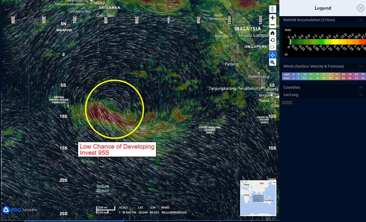
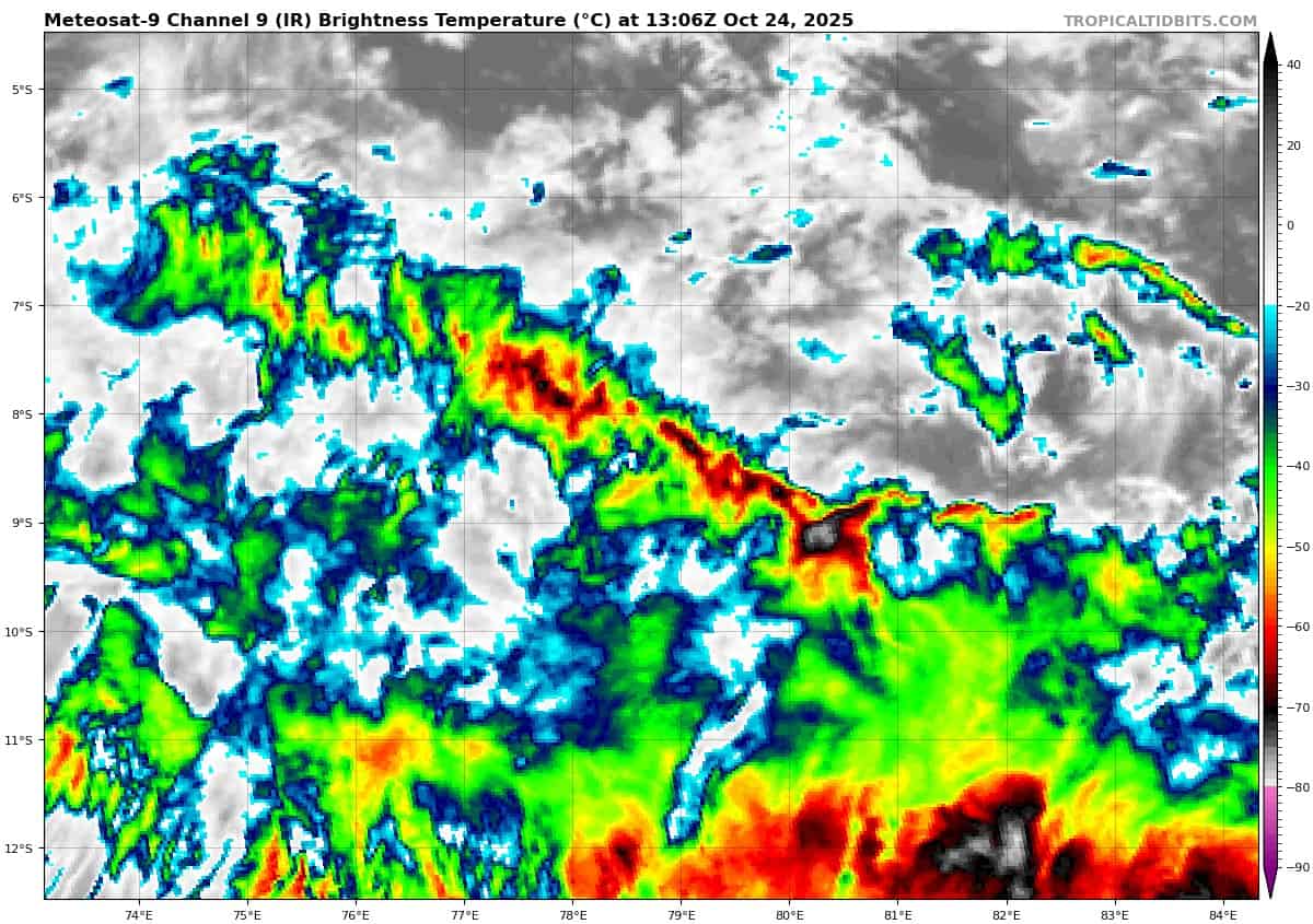
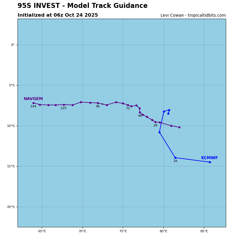
>>> There’s an area of disturbed weather being referred to as Invest 95S…which is located approximately 431 NM east of Diego Garcia
Enhanced infrared satellite imagery (eir) depicts a broad area of troughing with flaring convection.
Environmental analysis reveals marginal conditions for development with high vertical wind shear (20-25 knots), poleward outflow aloft, and warm sea surface temperatures (28-29c).
Global models have consistently indicated a lower likelihood of development of invest 95S through the last several runs, instead revealing an asymmetric trough with enhanced winds along the southern periphery. The disturbance is expected to continue on a westward track towards Diego Garcia.
Maximum sustained surface winds are estimated at 22 to 28 knots.
The potential for the development of a significant tropical cyclone within the next 24 hours is downgraded to low.
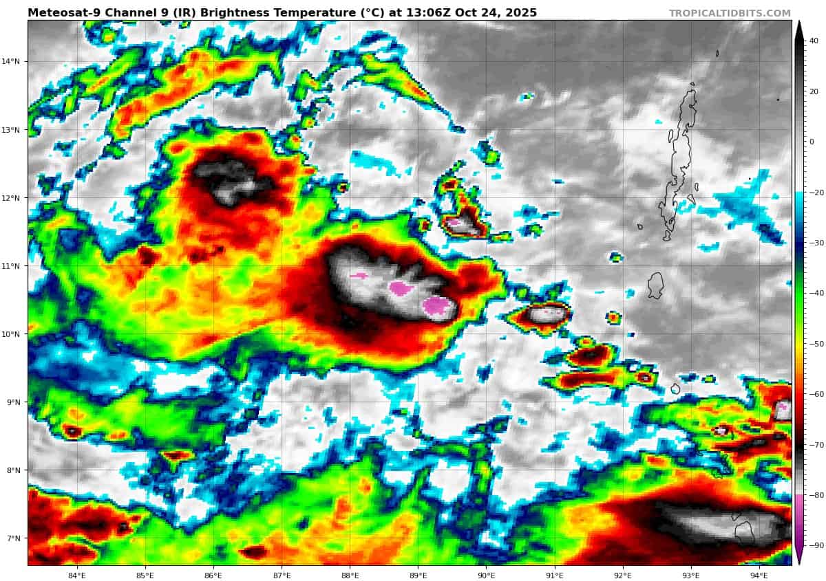
North Indian Ocean
>>> There’s an area of disturbed weather being referred to as Invest 94B…which is located approximately 532 NM east-southeast of Chennai, India
Enhanced infrared satellite imagery (eir) depicts a consolidating llcc embedded within a trough that extends from the coast of southeastern India to the Andaman Island chain. Convection continues to flare near the llcc but is sheared by the persistent easterly vertical wind shear.
Environmental analysis reveals a favorable environment for development with moderate westward and equatorward upper level outflow, low (5-15 kts ) vertical wind shear, and warm sea surface temperatures of 28-29 c.
Global deterministic and ensemble models show 94B consolidating over the next 24-48 hours before tracking generally northwestward.
Maximum sustained surface winds are estimated at 23 to 28 knots.
The potential for the development of a significant tropical cyclone within the next 24 hours is low.
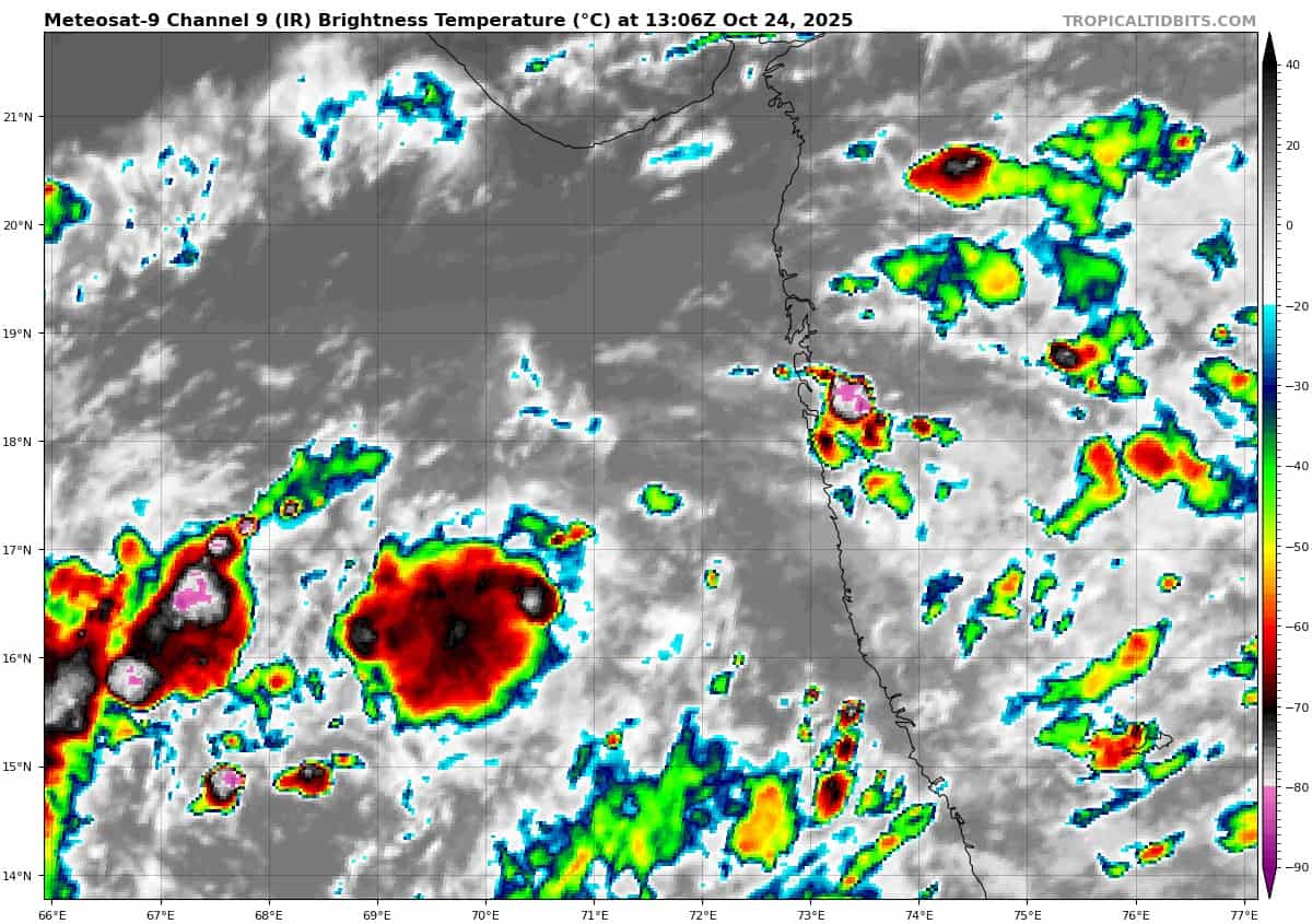
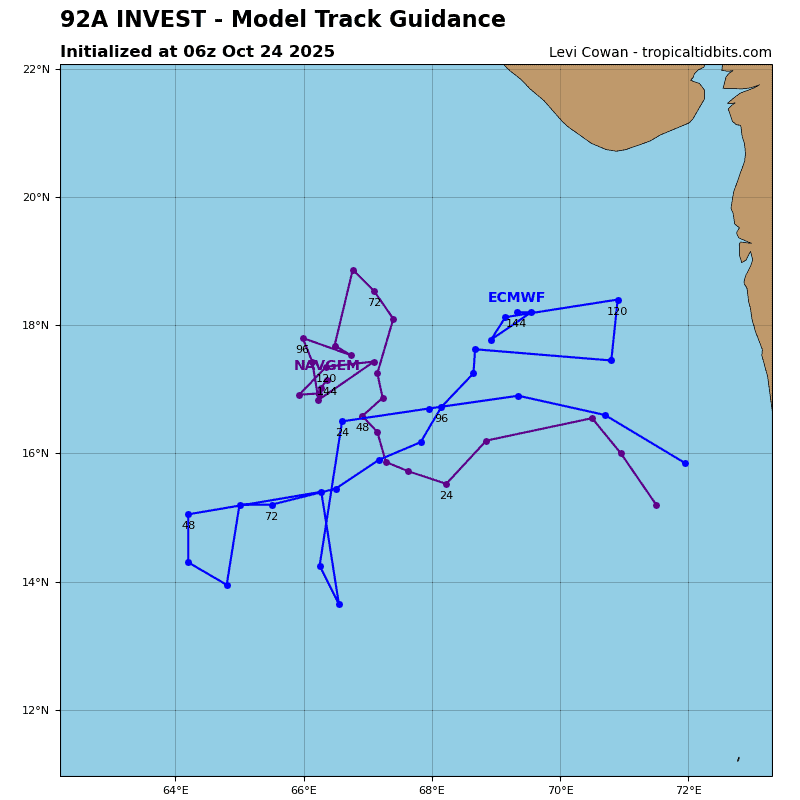
Arabian Sea
>>> There’s an area of disturbed weather being referred to as Invest 92A…which is located approximately 136 NM southwest of Mumbai, India
Enhanced infrared satellite imagery (eir) depicts a broad circulation with flaring convection associated with the low-level circulation center (llcc).
Environmental analysis reveals marginal conditions for development with moderate to unfavorable vertical wind shear (20-25 knots), moderate poleward and equatorward outflow, and warm surface temperatures (28-29 c).
Global deterministic and ensemble models depict a broad circulation with gradual development.
Maximum sustained surface winds are estimated at 23 to 28 knots.
The potential for the development of a significant tropical cyclone within the next 24 hours remains low.