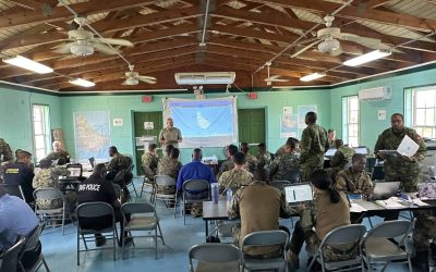
The Government of Indonesia’s (GoI) National Disaster Management Agency (Badan Nasional Penanggulangan Bencana, BNPB) hosted a series of capacity building activities this year, during the Mentawai Megathrust Disaster Relief Exercise 2014 (MM DiREx). The activities largely took place in the city of Padang, West Sumatra, Indonesia, March 17–23, and centered on a fictional 8.9 magnitude earthquake off the coast of Siberut Island, in the Mentawai Island group. The scenario included both the earthquake and a resulting 10-meter tsunami impacting approximately 1.3 million people .
The event was themed Strengthening Collaboration and Partnership in Disaster Response to Build a Resilient Region, and included both a Command Post Exercise (CPX) and a Field Training Exercise (FTX) with the participation of around 3,700 personnel from 17 countries and international organizations. This broad level of stakeholder engagement will help advance national preparedness goals. This is critical as the Indonesian region is located between three tectonic plates and is renowned for its high risk to geological disasters, such as earthquakes and tsunamis. Specifically, such disaster mitigation exercises allow participating agencies to test and refine emergency protocols, especially those requiring interagency communication and coordination.
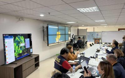
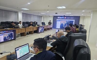
Participants worked to expand decision making capabilities within the incident command system, evaluate coordination and planning for emergency response, enhance international cooperation, and strengthen information sharing mechanisms via the Indonesia Tsunami Early Warning System (InaTEWS), and the newly released early warning and decision support system, InAWARE, which is based on Pacific Disaster Center’s (PDC) DisasterAWARE platform. InAWARE is being deployed and operationalized within BNPB under U.S. Agency for International Development (USAID) Office of Foreign Disaster Assistance (OFDA) funding.
PDC Geospatial Information Specialist John Livengood supported BNPB staff in the utilization of InAWARE and provided help in using the customized system to track scenario injects, as well as assisting in the development and dissemination of daily situation reports. Additionally, information, such as status of critical facilities, response teams, and command post updates were added to InAWARE and overlaid with inundation maps and baseline infrastructure to produce a common operating picture.
Indonesian Vice President Boediono attended the event on March 21. Other GoI authorities were also represented, including BNPB, the Indonesian Agency for Meteorological, Climatological, and Geophysics (Badan Meteorologi, Klimatologi, dan Geofisika, BMKG), the National Search and Rescue Agency (Badan SAR Nasional, BASARNAS), the Indonesian National Armed Forces (Tentara Nasional Indonesia, TNI), and the Ministry of Public Works (Pekerjaan Umum, PU) along with various regional authorities. In addition, international participants representing Australia, Brunei, Cambodia, Japan, Malaysia, Myanmar, Russia, New Zealand, Vietnam, and the U.S. were engaged, as well as international organizations, including ASEAN’s Coordinating Centre for Humanitarian Assistance on Disaster Management (AHA Centre), the United Nations Office for the Coordination of Humanitarian Affairs (UNOCHA), the International Federation of Red Cross and Red Crescent Societies (IFRC), the World Food Programme (WFP), and Mercy Corps.
For additional information about the MM DiREx:
• Find background information on their event site.
• View a Jakarta Post article on Relief Web.
To find more disaster-related news and information on Indonesia, explore these links:
• Learn about the deployment of InAWARE at BNPB.
• See how InAWARE was highlighted during a UN-SPIDER meeting.
• Read about the InAWARE kickoff workshop in Jakarta.
• Look over information about the Great Sumatra Earthquake and Indian Ocean Tsunami.
ABOUT PDC
Pacific Disaster Center (PDC) is a leading scientific innovator of global risk reduction science and technology. As a University of Hawai’i applied science and research center, our work intersects with a variety of government, community, academic, and scientific organizations at home and around the world to build resilience to natural and man-made hazards—enhancing the capacity to quickly and accurately anticipate and prepare for new and emerging threats. Our innovations in multi-hazard early warning systems, predictive analytics, data science, and machine learning provide decision-makers with the powerful tools and insights they need to navigate today’s complex and interconnected risk landscape.