
")
Current Snapshot
For all the latest updates visit: DisasterAWARE

1800×1080
grant
09S_281200sair
09S_tracks_latest
10s
10S_281200sair

10S_tracks_latest
goes18_ir_99P_202512281445_lat-13.4-lon-170.1
99P_tracks_latest
By PDC’s Senior Weather
Specialist Glenn James

The Pacific Disaster Center’s (PDC Global) Sunday, December 28, 2025, Tropical Cyclone Activity Report…for the Pacific Ocean, the Indian Ocean, and adjacent Seas
Current Tropical Cyclones:
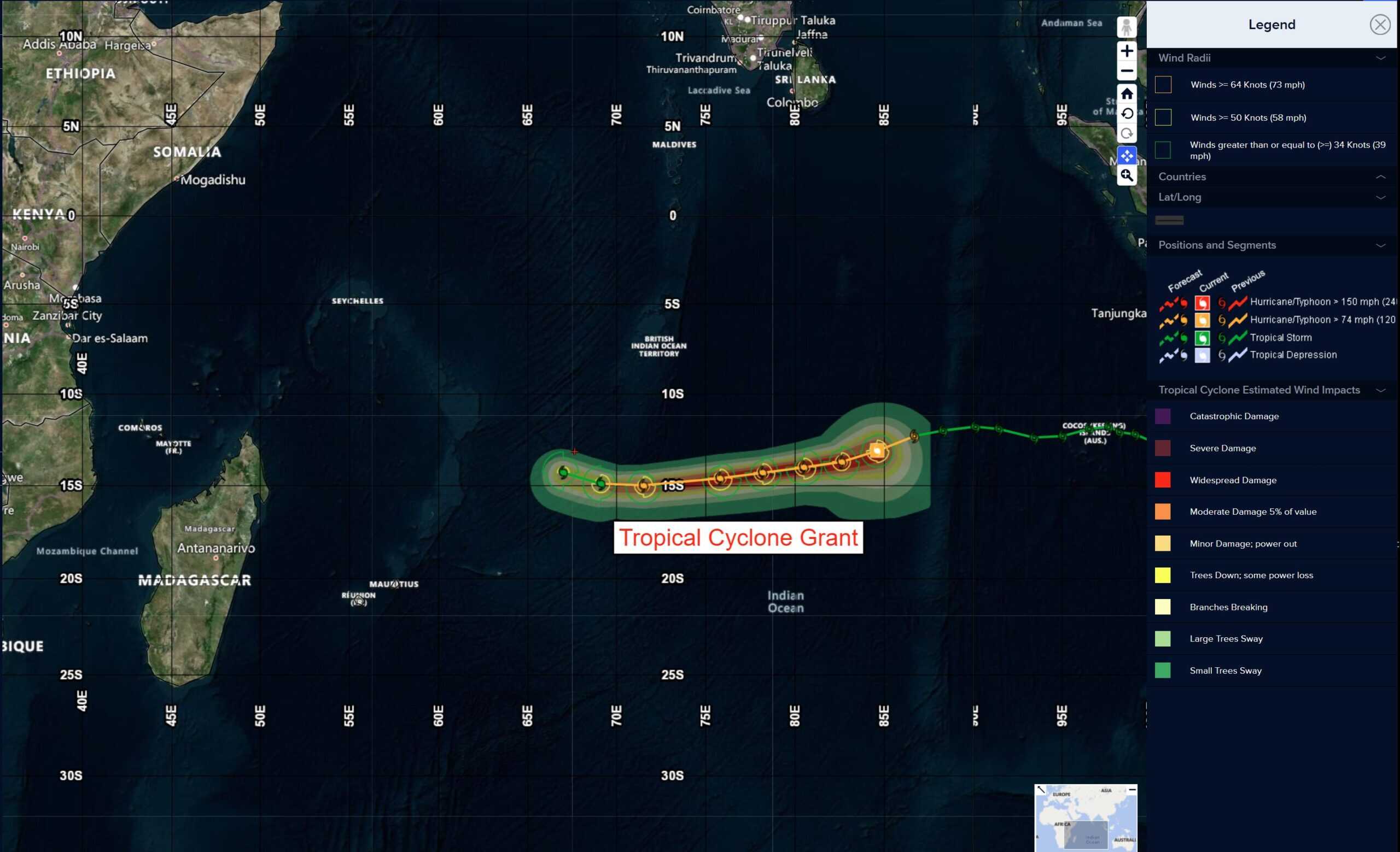
Tropical Cyclone 09S (Grant) is located approximately 800 NM east-southeast of Diego Garcia
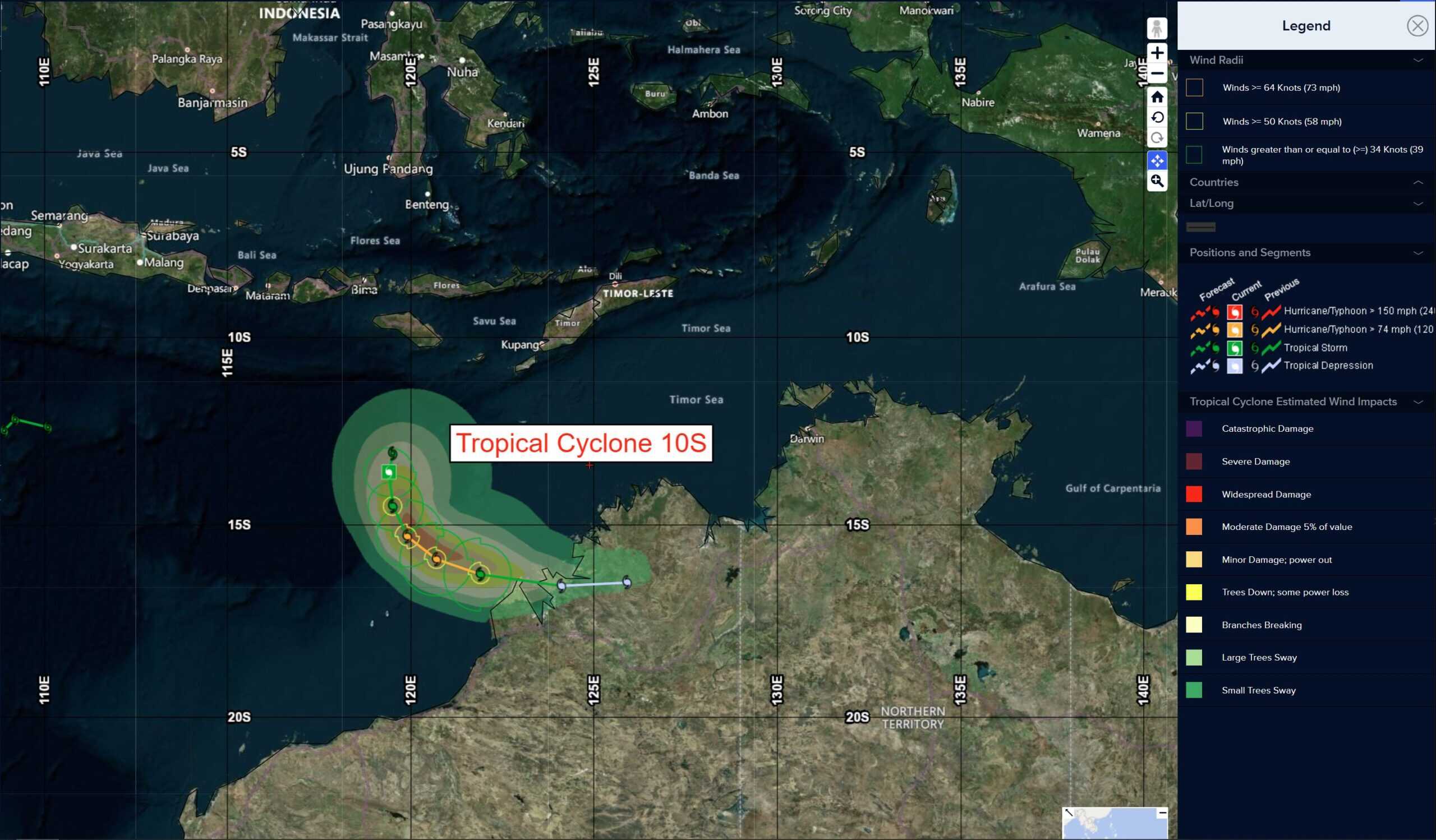
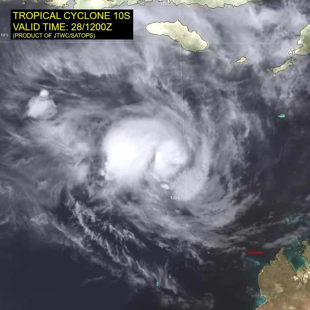
Tropical Cyclone 10S (Hayley) is located approximately 251 NM northwest of Broome, Australia
Northeast Pacific Ocean: There are no Tropical Cyclones
The last regularly scheduled Tropical Cyclone Activity Report of the 2025 eastern North Pacific Hurricane Season has been issued. Routine issuance of this section of the PDC product will resume on May 15, 2026. During the off-season, Special Tropical Weather Outlooks will be issued as conditions warrant by the NHC.
Central Pacific Ocean: There are no Tropical Cyclones
The 2025 central North Pacific hurricane season has ended. As such, the final routine Tropical Cyclone Activity Report for the 2025 season has been issued. Routine issuance of this section of the PDC product will resume on June 1, 2026. During the off-season, Special Tropical Weather Outlooks will be issued as conditions warrant by the CPHC.
Western Pacific, Indian Ocean, and adjacent Seas:
South Indian Ocean
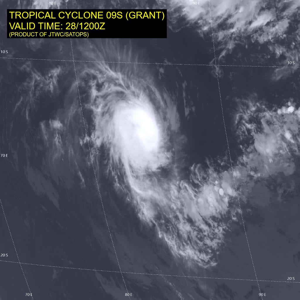
Tropical Cyclone 09S (Grant)
According to the JTWC warning number 24, sustained winds are 105 knots with 130 knot gusts
Animated enhanced infrared (eir) satellite imagery depicts tropical cyclone 09S (Grant) with a highly compact central dense overcast (cdo) obscuring the low-level circulation center (llcc). Cloud tops within the core of the system are now measuring colder than -90 c in some areas.
Environmental analysis indicates that 09S is in a marginally favorable environment characterized by moderate poleward outflow aloft, low (10-15 kts) easterly vertical wind shear, and warm (27-28 c) sea surface temperatures.
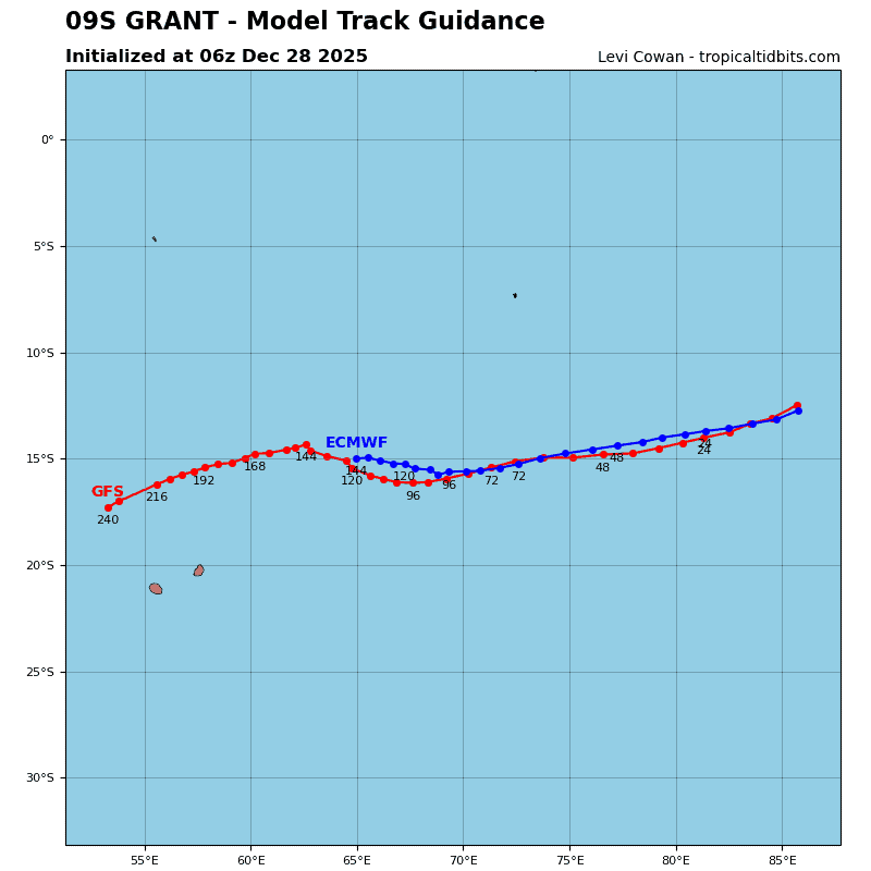
TC 09S is forecast to track west-southwestward, along the northern periphery of the str to the south through 48 hours. Near 48 hours, a second str is expected to build to the southwest of 09S and propagate eastward, keeping the trajectory firmly west-southwestward through 96 hours. Near 96 hours, 09S is forecast to begin interacting with ridging that extends from eastern Africa over northern Madagascar, causing the track to shift west-northwestward near the end of the forecast period.
Regarding intensity, 09S is forecast to intensify over the next 36-48 hours as easterly shear lessens and poleward outflow becomes enhanced by a passing upper-level trough to the south. After 48 hours, shear is expected to increase and outflow decrease causing the system to begin weakening. Additionally, dry air entrainment from the north will further aid in weakening the system through the remainder of the forecast period.
Tropical Cyclone 10S (Hayley)
According to the JTWC warning number 4, sustained winds are 55 knots with 70 knot gusts
TC 10S has slowly developed over the past six hours. Animated enhanced infrared (eir) satellite imagery depicts persistent deep convection over a compact low-level circulation center evident in a
280825z ssmis pass.
TC 10S is expected to track generally poleward over the next 12 hours under the continued steering influence of deep layer ridging to the east. Thereafter, the system will take a gradual eastward turn as ridging to the east reorients and a building near-equatorial ridge to the north becomes the dominant steering mechanism.
The system is expected to continue intensifying for the next 24 hours under the favorable influences of low vertical wind shear, passage over very warm water, and poleward outflow enhanced by passage of an upper-level trough to the south.
After 24 hours, the system will encounter increasing westerly flow aloft as the upper-level flow pattern shifts, halting the intensification trend. increasing shear and consequent entrainment of drier air will weaken the system before it skirts or makes landfall along the Dampier Peninsula between 48 and 72 hours. The unfavorable upper-level flow pattern and passage over land will dissipate the system by 72 hours.
Southwest Pacific Ocean
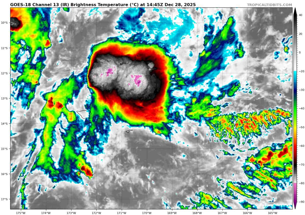
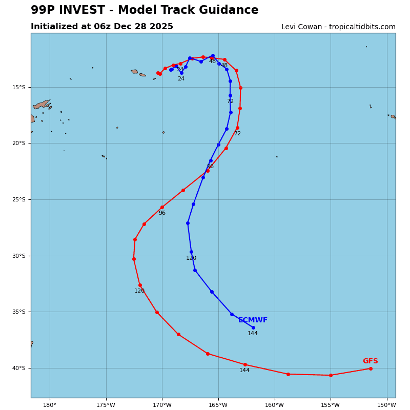
>>> There’s an area of disturbed weather being referred to as Invest 99P, which is located approximately 63 NM north-northeast of Pago Pago, American Samoa
Animated enhanced infrared satellite imagery depicts deep convection building over the northern semicircle of a compact low-level circulation center (llcc).
Environmental analysis reveals a favorable environment for development with moderate poleward upper-level outflow, low vertical wind shear (10 to 15 kts), and warm sea surface temperatures (29 to 30 c).
Global models agree on 99P tracking generally eastward as it further consolidates over the next 24 to 48 hours.
Maximum sustained surface winds are estimated at 25 to 28 knots.
The potential for the development of a significant tropical cyclone within the next 24 hours is upgraded to medium.