
")
Current Snapshot
For all the latest updates visit: DisasterAWARE

1800×1080

grant
09S_261200sair
himawari9_ir_09S_202512261430_lat-11.9-lon91.4
09S_tracks_latest
By PDC’s Senior Weather
Specialist Glenn James

The Pacific Disaster Center’s (PDC Global) Friday, December 26, 2025, Tropical Cyclone Activity Report…for the Pacific Ocean, the Indian Ocean, and adjacent Seas
Current Tropical Cyclones:
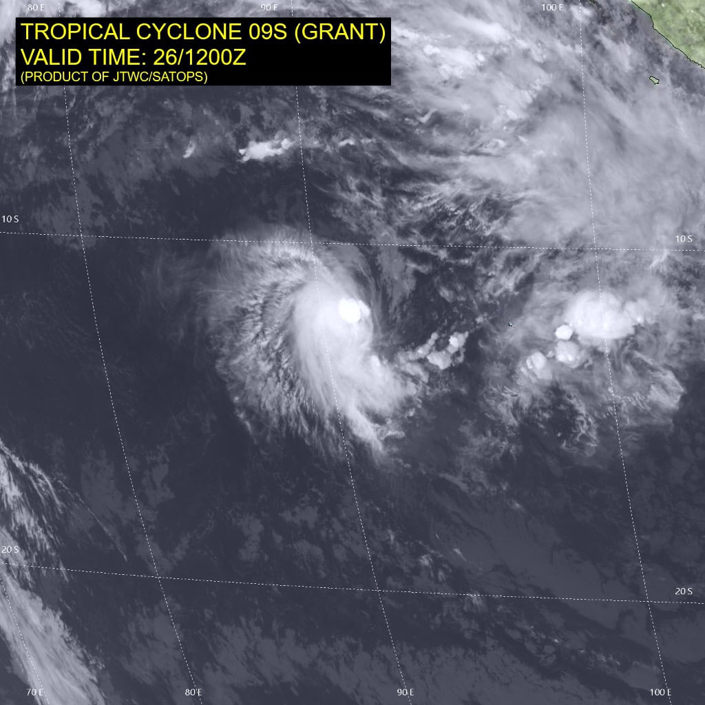
Tropical Cyclone 09S (Grant) is located approximately 400 NM west of the Cocos Islands
Northeast Pacific Ocean: There are no Tropical Cyclones
The last regularly scheduled Tropical Cyclone Activity Report of the 2025 eastern North Pacific Hurricane Season has been issued. Routine issuance of this section of the PDC product will resume on May 15, 2026. During the off-season, Special Tropical Weather Outlooks will be issued as conditions warrant by the NHC.
Central Pacific Ocean: There are no Tropical Cyclones
The 2025 central North Pacific hurricane season has ended. As such, the final routine Tropical Cyclone Activity Report for the 2025 season has been issued. Routine issuance of this section of the PDC product will resume on June 1, 2026. During the off-season, Special Tropical Weather Outlooks will be issued as conditions warrant by the CPHC.
Western Pacific, Indian Ocean, and adjacent Seas:
South Indian Ocean
Tropical Cyclone 09S (Grant)
According to the JTWC warning number 20, sustained winds are 60 knots with 75 knot gusts
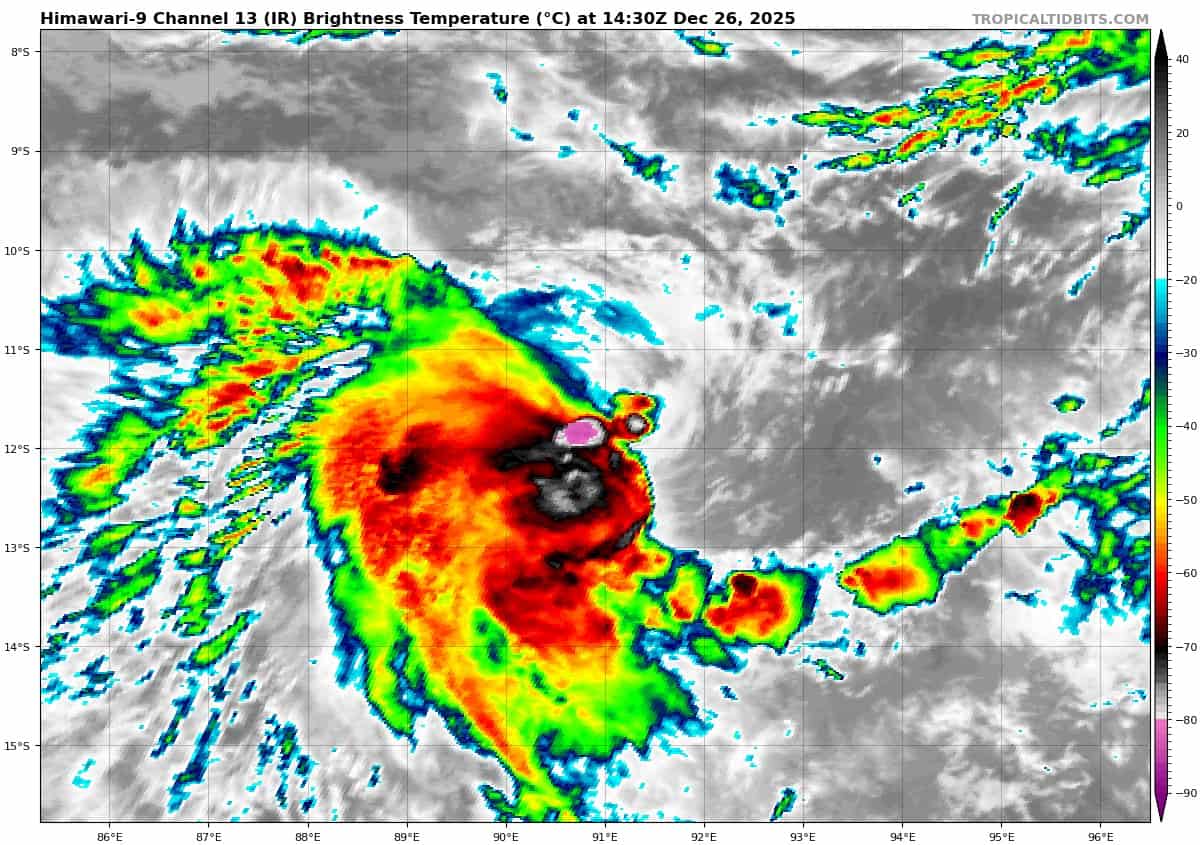
Animated enhanced infrared (eir) satellite imagery depicts tropical cyclone 09S (grant) with a low-level circulation center (llcc) and deep convection that is being sheared to the southwest. Cloud top temperatures surrounding the center have continued to cool over
the past twelve hours though the structure has become more tilted.
Additional environmental analysis reveals warm (27-28 c) sea surface temperatures (sst), offset by high (20-25 kts) vertical wind shear (vws).
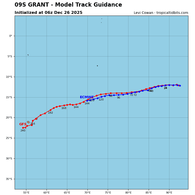
Tropical cyclone 09S will continue to track westward to west-southwestward under the influence of the subtropical ridge to the south. Improving environmental conditions, including reduced vws and warm ssts, will allow the system to intensify at a steady pace with a peak intensity of 75 kts forecast at 96 hours, as long as the system manages to limit the tilt of the vertical structure.
Though low to moderate (15-20 kts) vws and improving outflow are expected, dry air entrainment is forecast to keep the system from intensifying rapidly.
>>> There’s an area of disturbed weather being referred to as Invest 96S, which is located approximately 223 NM north of Rowley Shoals
Animated multi-spectral satellite imagery depicts a consolidating low level circulation center with weak convective banding within the northern periphery and minor flaring convection near the center.
Environmental analysis shows a marginally favorable environment for development with moderate equatorward outflow aloft, low vertical wind shear (10 to 15 kts), and warm sea surface temperatures (29 to 30 c).
Global models show 96S continuing to consolidate with a highly compact wind field. GFS is the most aggressive model, showing quick development over the next 24 hours. models generally agree on 96S tracking slowly southward over the next 36-48 hours.
Maximum sustained surface winds are estimated at 18 to 23 knots.
The potential for the development of a significant tropical cyclone within the next 24 hours is low.