
")
Current Snapshot
For all the latest updates visit: DisasterAWARE
epac
1800x1080ee
koto
33W_251200sair
33W_tracks_latest
04b
04B_251200sair
04B_tracks_latest
96b
By PDC’s Senior Weather
Specialist Glenn James

The Pacific Disaster Center’s (PDC Global) Tuesday, November 25, 2025, Tropical Cyclone Activity Report…for the Pacific Ocean, the Indian Ocean, and adjacent Seas
Current Tropical Cyclones:
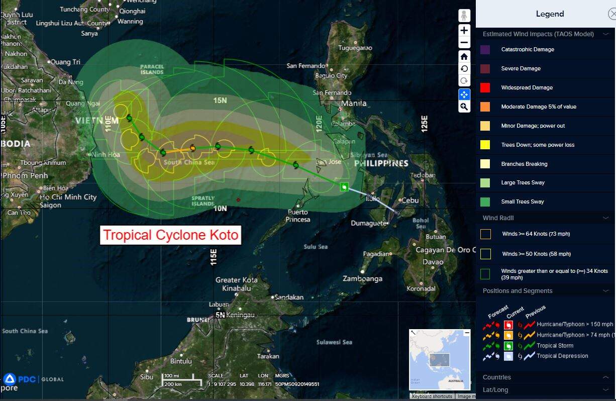
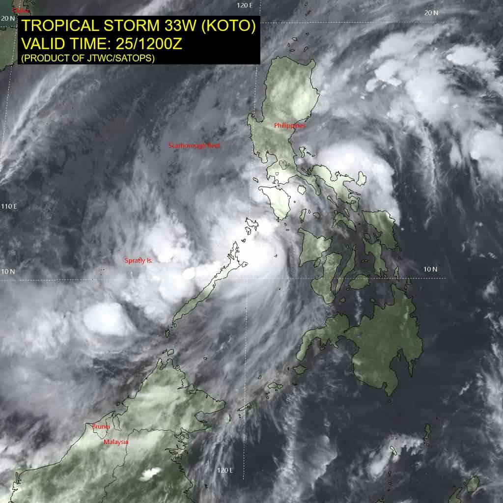
Tropical Cyclone 33W (Koto)…is located 235 NM west-southwest of Manila, Philippines
Tropical Cyclone 04B…is located approximately 645 NM southwest of Ho Chi Minh City, Vietnam
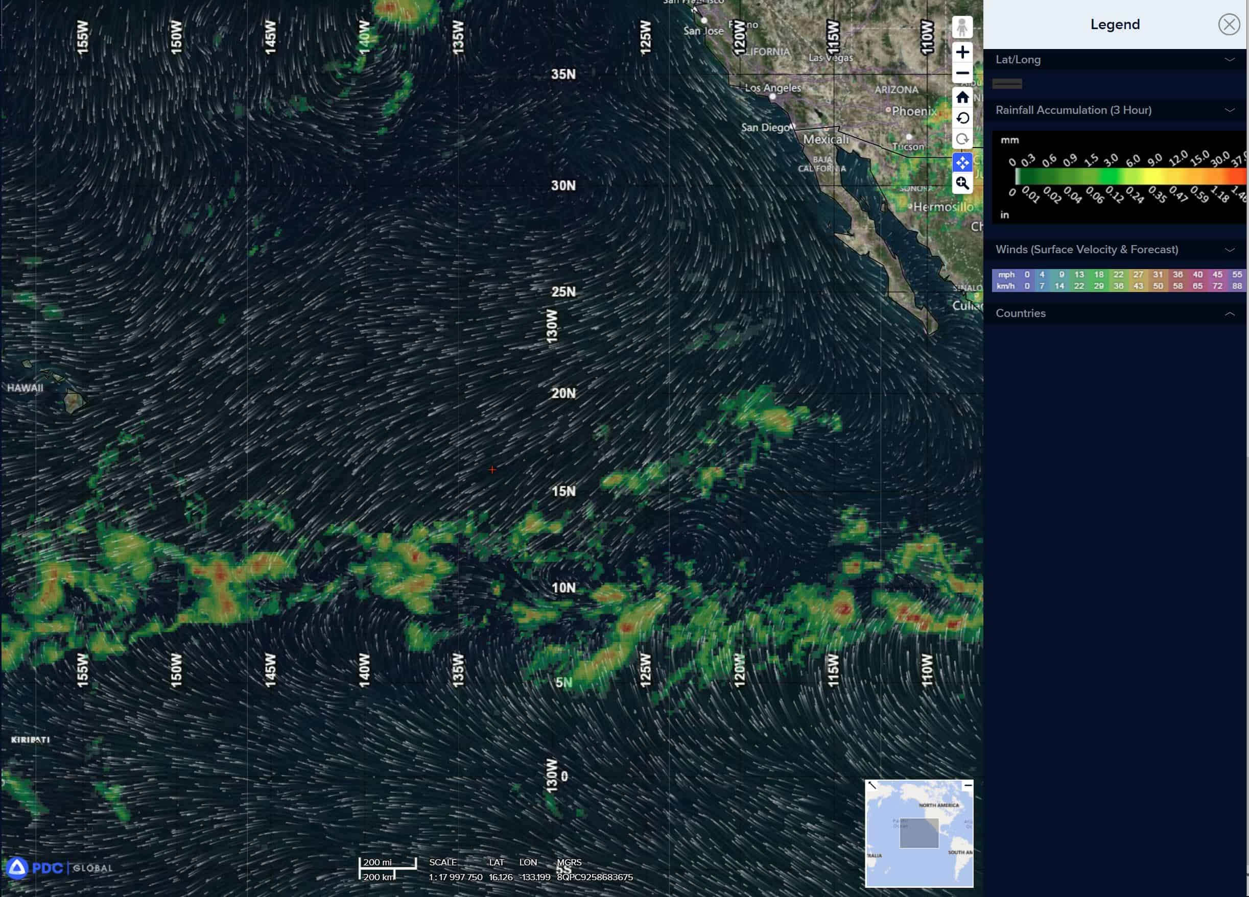
Northeast Pacific Ocean: There are no Tropical Cyclones
Tropical cyclone formation is not expected during the next 7 days.
Central Pacific Ocean: There are no Tropical Cyclones
Tropical cyclone formation is not expected during the next 7 days.
Western Pacific, Indian Ocean, and adjacent Seas:
Western Pacific
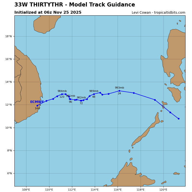
Tropical Cyclone 33W (Koto)
According to the JTWC warning number 6, sustained winds were 55 knots, with gusts to near 70 knots
Animated multi-spectral satellite imagery (msi) depicts tropical storm 33W with improving deep convection building over the center of the obscured low-level circulation center (llcc). A 250503z amsr2 89 ghz microwave image revealed tightly curved convective banding beginning to form near the assessed center.
Environmental analysis indicates that 33W is in a favorable environment characterized by strong poleward and equatorward outflow aloft, low (10-15 kts) southeasterly vertical wind shear, and warm (28-29 c) sea surface temperatures.
33W is forecast to continue tracking west-northwestward along the southwestern periphery of the subtropical ridge to the northeast through 24 hours. Near 24 hours, 33W will enter an area of weak steering influence, causing track speeds to quickly decrease. The system will be placed between ridging to both the east and west as a major shortwave trough digs in from the north.
As a result, slow westward movement is forecast from 24-72 hours. After 72 hours, ridging is expected to build back in over the northern Philippines, causing 33W to drift northwestward through the remainder of the forecast period.
Regarding intensity, 33W is forecast to quickly intensify through 24 hours to around 55 kts as shear remains low and the system keeps a distance from the northeasterly surge. From 24 to 48 hours, intensification is expected to continue, but at a slower pace as southerly shear increases and dry air from the surge begins to impact the vortex.
From 48 to 96 hours, slight weakening is forecast to occur as the dry air continues to penetrate the vortex. After 96 hours, shear and dry air are forecast to lessen as the northeasterly surge retreats. Re-intensification is possible near the very end of the forecast period as the environment becomes more favorable.
North Indian Ocean
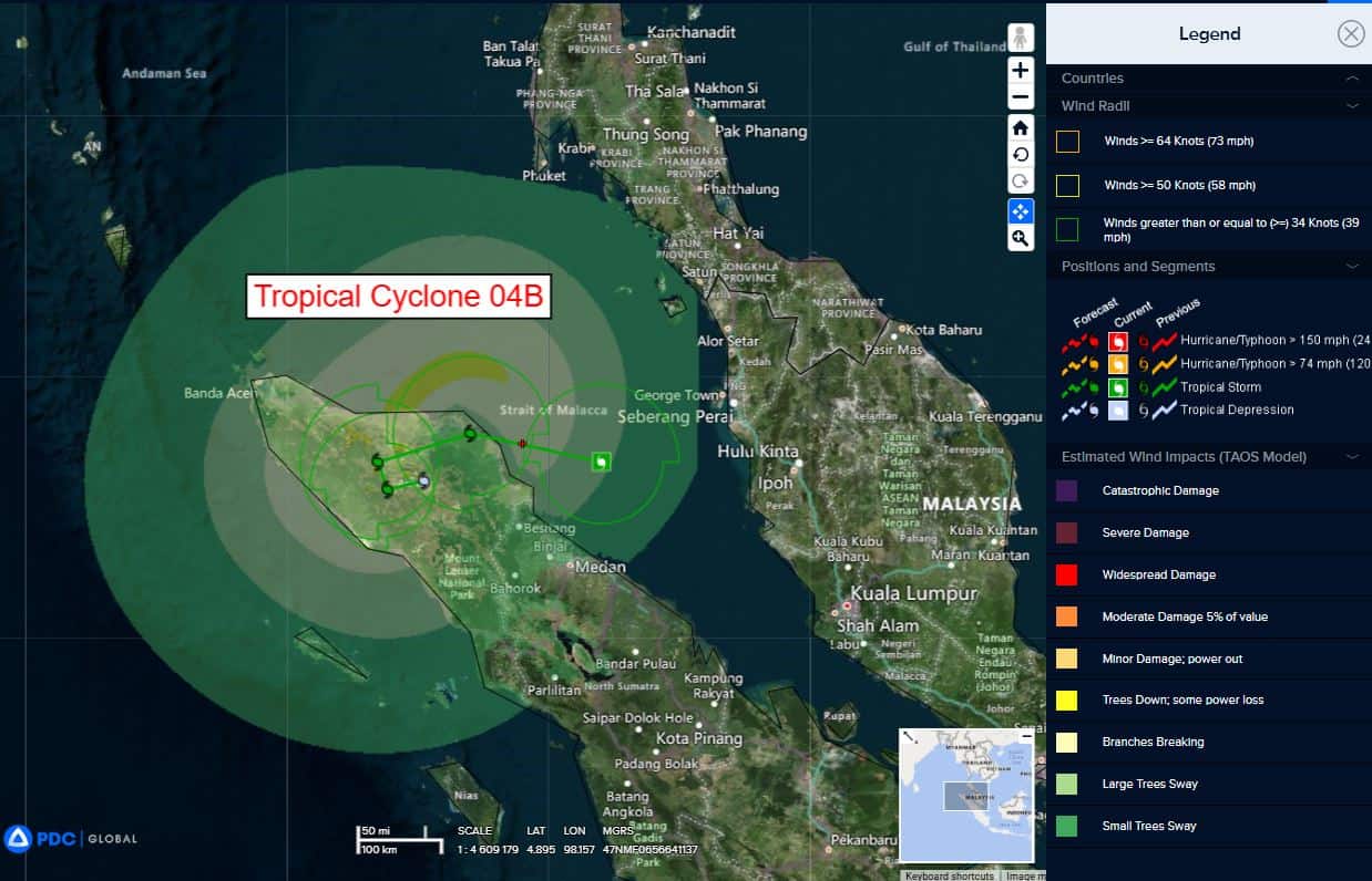
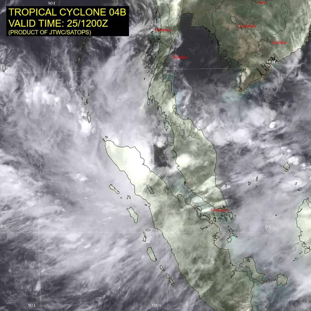
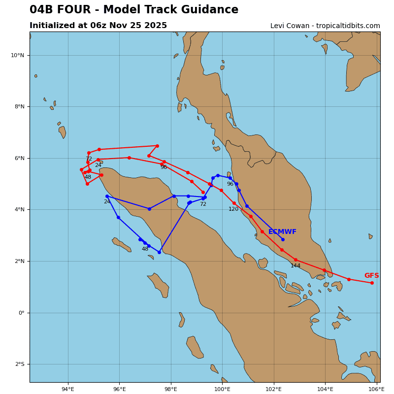
Tropical Cyclone 04B
According to the JTWC warning number 3, sustained winds were 45 knots, with gusts to near 55 knots
Animated enhanced infrared (eir) satellite imagery depicts tropical cyclone 04B with a partially exposed low-level circulation center (llcc) and deep convection sheared off to the west. The exposed eastern portion of the llcc shows that the llcc is well-defined and highly compact.
Environmental analysis indicates that 04B is in a marginally favorable environment characterized by weak outflow aloft, moderate (15-20 kts) easterly vertical wind shear, and warm (28-29 c) sea surface temperatures.
04B is forecast to track generally westward, along the southern periphery of the subtropical ridge to the north, through 24 hours. After 24 hours, 04B becomes placed within a competing steering environment as enhanced low-level westerly flow begins to interact with the vortex.
The combination of these two factors is expected to result in very slow and erratic movement through 48 hours. The JTWC track forecast calls for a check mark back to the east after 24 hours as the vortex shallows over the mountainous terrain of northern Sumatra and the low-level steering becomes the primary mechanism.
Regarding intensity, 04B is forecast to intensify over the next 12 hours as it remains over water with low to moderate shear. After 12 hours, terrain interaction will cause 04W to weaken. As the vortex stalls over northern Sumatra, the vortex will continue to erode over land with dissipation forecast to occur around 48 hours.
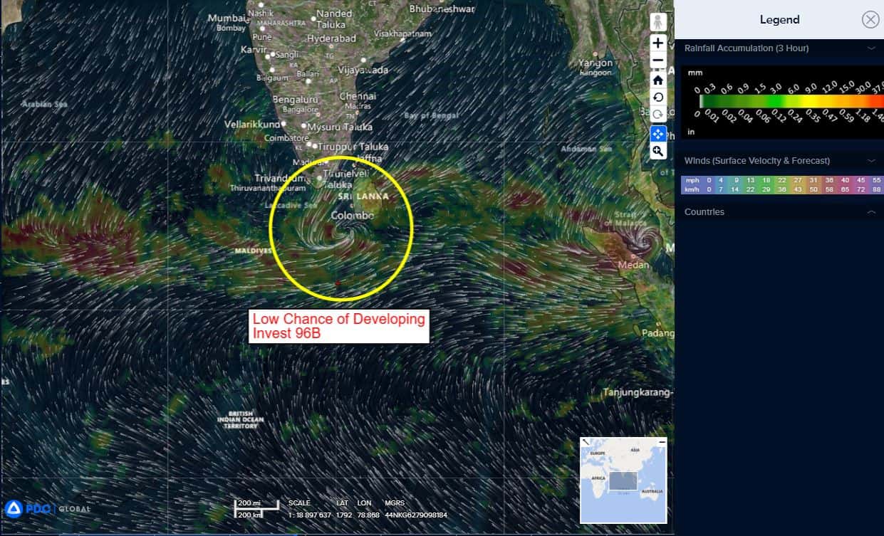
>>> There’s an area of disturbed weather being referred to as Invest 96B, which is located approximately 200 NM east-southeast of Colombo, Sri Lanka
Animated enhanced infrared satellite imagery (eir) and a 251948z gmi 89ghz microwave pass depict a partially obscured, elongated low level circulation center (llcc) with fragmented convection and formative banding along the southern and western peripheries.
Environmental analysis reveals a favorable environment for development with low vertical wind shear (vws) of 10-15 knots, dual-channel outflow, and warm sea surface temperatures (sst) of 28-29 c.
Deterministic and ensemble models are in good agreement portraying 96b to continue to consolidate over the next 48
hours as it tracks along the southern and eastern coasts of Sri
Lanka.
Maximum sustained surface winds are estimated at 23 to 27 knots.
The potential for the development of a significant tropical cyclone within the next 24 hours is upgraded to medium.