

")
Current Snapshot
For all the latest updates visit: DisasterAWARE

epac
1800x1080e
fina
05S_221200sair
05S_tracks_latest
By PDC’s Senior Weather
Specialist Glenn James

The Pacific Disaster Center’s (PDC Global) Saturday, November 22, 2025, Tropical Cyclone Activity Report…for the Pacific Ocean, the Indian Ocean, and adjacent Seas
Current Tropical Cyclones:
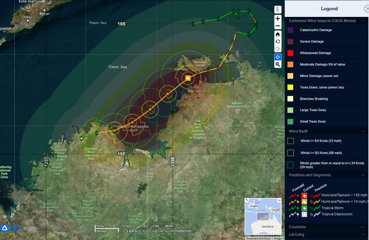
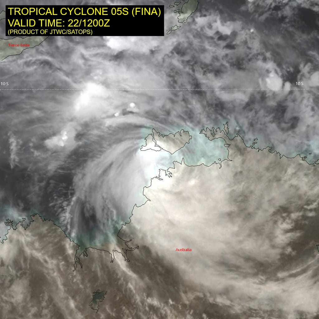
Tropical Cyclone 05S (Fina)…is located 65 NM west of Darwin, Australia
Northeast Pacific Ocean: There are no Tropical Cyclones
Tropical cyclone formation is not expected during the next 7 days.
Central Pacific Ocean: There are no Tropical Cyclones
Tropical cyclone formation is not expected during the next 7 days.
Western Pacific, Indian Ocean, and adjacent Seas:
South Indian Ocean
Tropical Cyclone 05S (Fina)
Tropical cyclone 05S has tracked slowly west-southwestward away from southern Melville Island. Animated enhanced infrared (eir) satellite imagery depicts a weakened eye feature and general weakening of the convective structure due to the interaction with land. However, animated radar imagery reveals spiral banding wrapping into a defined eye, which supports the initial position with high confidence.</
Due to the recent track motion, the center is about 25 NM northwest of Darwin at 221200z, which is reporting an increase in sustained winds to as high as 40 knots (10-minute average) at 221030z. Since 221030z the sustained winds have decreased slightly with slp increasing as the center drifts west-southwestward (221409z center position is near 12.19n 130.44e, approximately 30 NM northwest of Darwin).
Rainfall amounts have been significant within the intense rain bands over the southern semicircle, with about 6 inches reported at the Darwin airport over the past day. With exception of the land interaction, environmental conditions are favorable, with robust poleward outflow, moderate westward outflow, low vertical wind shear (vws) and warm sst values.
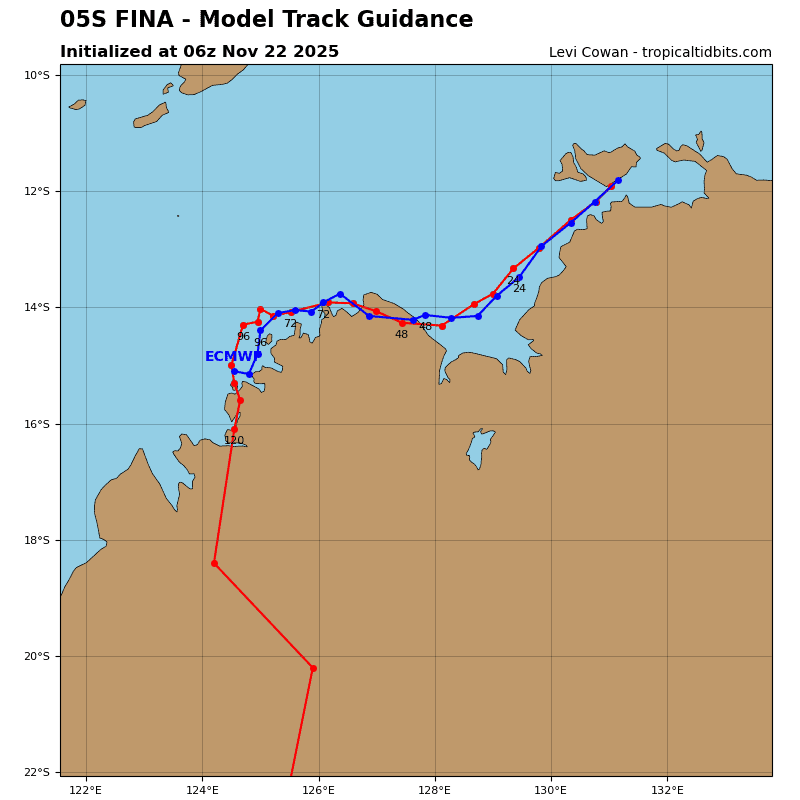
The western extension of the str is forecast to weaken with the approach of a major shortwave trough, which will allow TC 05S to track southwestward through 36 hours over the Joseph Bonaparte Gulf. After tracking away from Melville Island, TC Fina is forecast to briefly re-intensify through 12 hours under favorable conditions to a peak intensity of 95 knots.
Increasing dry air entrainment and high (25 knots) vws will begin to weaken the system near 24 hours, with steady weakening through 36 hours. after 36 hours, TC 05S will steer at a lower level, with a more westward track along the northern periphery of a low- to mid-level str to the south. Rapid weakening will occur due to extensive dry air advecting off Australia, with dissipation expected by 96 hours.
>>> There’s an area of disturbed weather being referred to as Invest 95B, which is located approximately 418 NM northwest of Singapore.
Animated enhanced infrared imagery (eir) depicts flaring convection obscuring a disorganized low level circulation that is getting sheared to the west.
Environmental analysis for this system is favorable, with low to moderate (15-20 kts) south-southeasterly deep layer vertical wind shear, warm (28-29 c) sea surface temperatures, and good divergence aloft.
Global deterministic models are in good agreement on a gradual development with gfs being the most aggressive showing an earlier timeline of development than ecmwf. Ensemble models show a general agreement on the system remaining quasi-stationary over the next 48 hours, with intensification afterwards, as the circulation transits west-northwest into the bay of bengal.
Maximum sustained surface winds are estimated at 18 to 23 knots.
The potential for the development of a significant tropical cyclone within the next 24 hours is low.