

")
Current Snapshot
For all the latest updates visit: DisasterAWARE
melissa
1000×1000
goes19_ir_13L_202510241315_lat15.9-lon-75.0
241156_earliest_reasonable_toa_34
241156INTQPF_sm
13L_tracks_latest
By PDC’s Senior Weather
Specialist Glenn James

The Pacific Disaster Center’s (PDC Global) Friday, October 24, 2025, Tropical Cyclone Activity Report…for the Atlantic Ocean, the Caribbean Sea, and the Gulf of America
Current Tropical Cyclones:
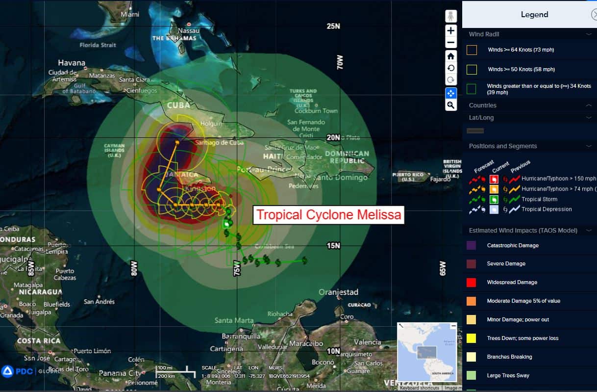
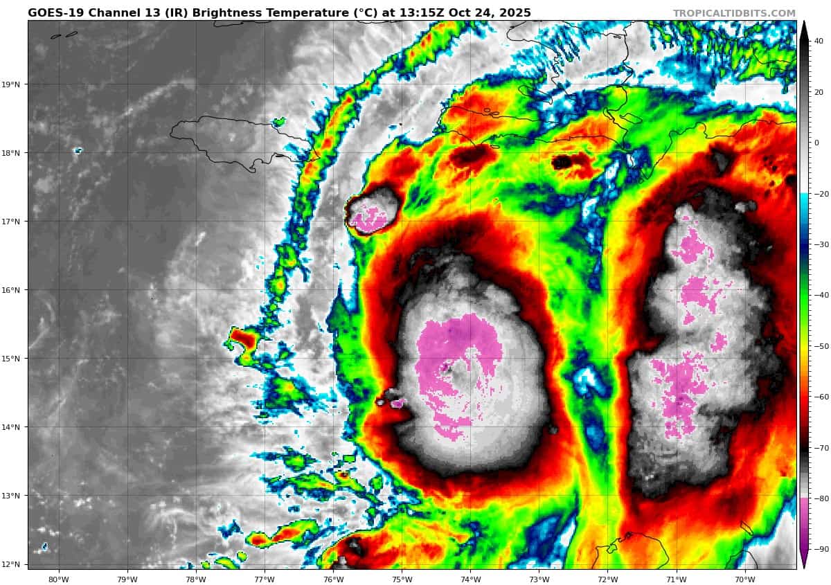
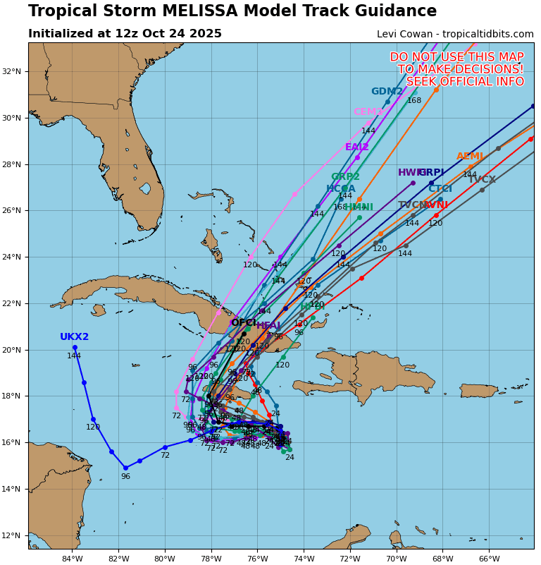
Tropical Cyclone Melissa…is located about 260 miles southwest of Port Au Prince, Haiti
Atlantic Ocean: There are no active tropical cyclones
Tropical cyclone formation is not expected during the next 7-days.
Caribbean Sea:
Tropical Cyclone Melissa
NOAA AND AIR FORCE RESERVE HURRICANE HUNTERS REPORT LITTLE CHANGE IN MELISSA’S STRENGTH DURING THE PAST FEW HOURS… LIFE-THREATENING AND CATASTROPHIC FLASH FLOODING AND LANDSLIDES EXPECTED IN PORTIONS OF SOUTHERN HISPANIOLA AND JAMAICA THROUGH THE WEEKEND
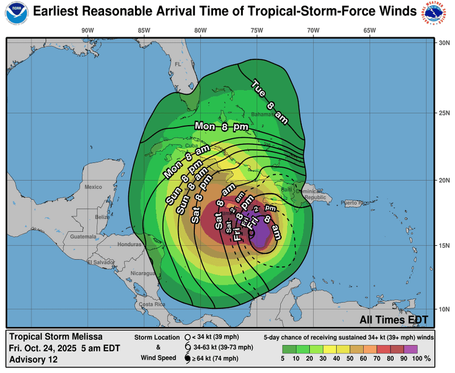
According to the NHC advisory number 14A
A turn to the west is forecast on Saturday and this general motion is expected to continue through Monday. A turn to the north and northeast is forecast on Tuesday and Wednesday. On the forecast track, the center of Melissa is expected to move near or over Jamaica early next week and could be near or over eastern Cuba by the middle of next week.
Reports from NOAA and Air Force Reserve Hurricane Hunter aircraft indicate that maximum sustained winds are near 65 mph (100 km/h) with higher gusts. Rapid intensification is forecast over the next several days, and Melissa is forecast to become a hurricane tomorrow and a major hurricane by Sunday.
Tropical-storm-force winds extend outward up to 140 miles (220 km) from the center. The minimum central pressure reported by the Hurricane Hunter aircraft is 993 mb (29.33 inches).
HAZARDS AFFECTING LAND
WIND: Hurricane conditions are possible within the watch area in Haiti on Saturday and Jamaica beginning late Saturday or Sunday. Tropical storm conditions are expected to begin in Haiti later today and in Jamaica on Saturday.
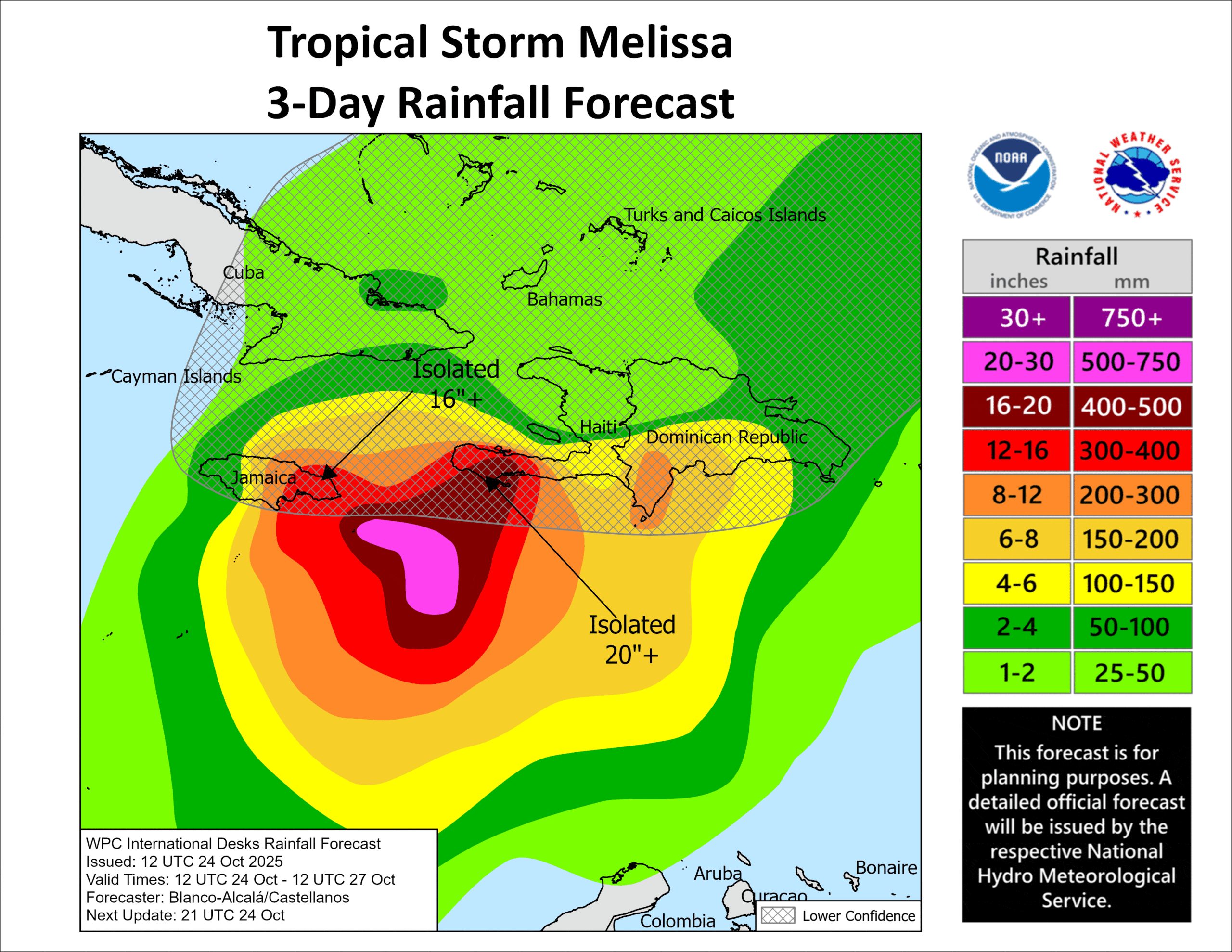
RAINFALL: Melissa is expected to bring 8 to 14 inches of rain to southern Dominican Republic, southern Haiti, and eastern Jamaica through Sunday night, with locally higher amounts possible. Additional heavy rainfall is likely beyond Sunday night; however, uncertainty in Melissa’s track and forward speed reduces confidence in exact totals. Significant, life-threatening flash flooding and numerous landslides are expected in the southern Dominican Republic and eastern Jamaica, with catastrophic flash flooding and landslides anticipated in southern Haiti.
Across northern Dominican Republic, northern Haiti, and western Jamaica, 3 to 5 inches of rain are expected through Sunday night. Flash and urban flooding will be possible through Sunday night. Flooding impacts may increase across western Jamaica next week.
SURF: Swells generated by Melissa are expected to affect portions of Hispaniola, Jamaica, and eastern Cuba during the next several days.
STORM SURGE: Minor coastal flooding is likely along the coast of Jamaica by Saturday in areas of onshore winds as tropical storm conditions begin to reach the area. However, there is a potential risk of a more significant storm surge, especially along the south coast of Jamaica, early next week. Due to Melissa’s slow motion and large forecast uncertainty, it is still too soon to know exactly how high the storm surge could reach.
Gulf of America: There are no active tropical cyclones
Tropical cyclone formation is not expected during the next 7-days.