
")
Current Snapshot
For all the latest updates visit: DisasterAWARE
1800×1080

epac2
7
feng
30W_191200sair
himawari8_ir_30W_202510191430_lat16.1-lon118.8
30W_tracks_latest
chenge
04S_191200sair
meteosat9_ir_04S_202510191436_lat-8.6-lon69.0
04S_tracks_latest
By PDC’s Senior Weather
Specialist Glenn James

The Pacific Disaster Center’s (PDC Global) Sunday, October 19, 2025, Tropical Cyclone Activity Report…for the Pacific Ocean, the Indian Ocean, and adjacent Seas
Current Tropical Cyclones:
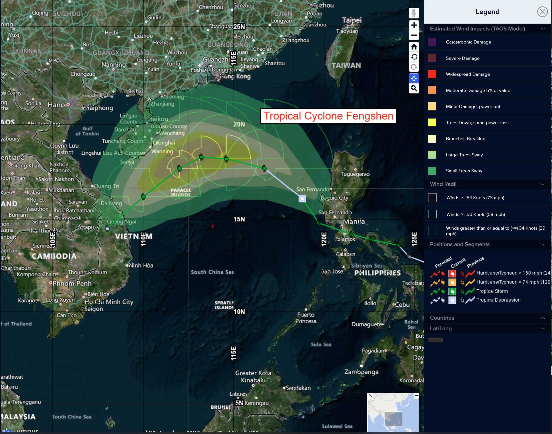
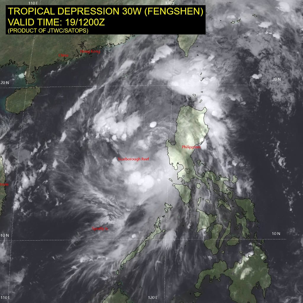
Tropical Cyclone 03W (Fengshen)…is located approximately 535 NM east of Da Nang, Vietnam
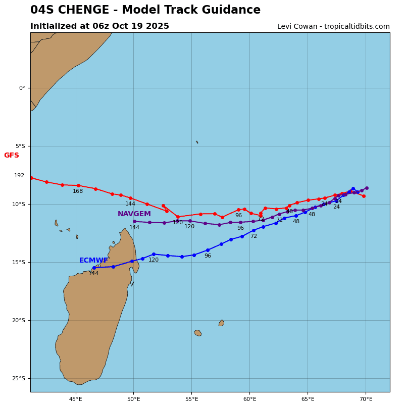
Tropical Cyclone 04S (Chenge)…is located approximately 271 NM west-southwest of Diego Garcia
Northeast Pacific Ocean: There are no Tropical Cyclones
Central East Pacific:
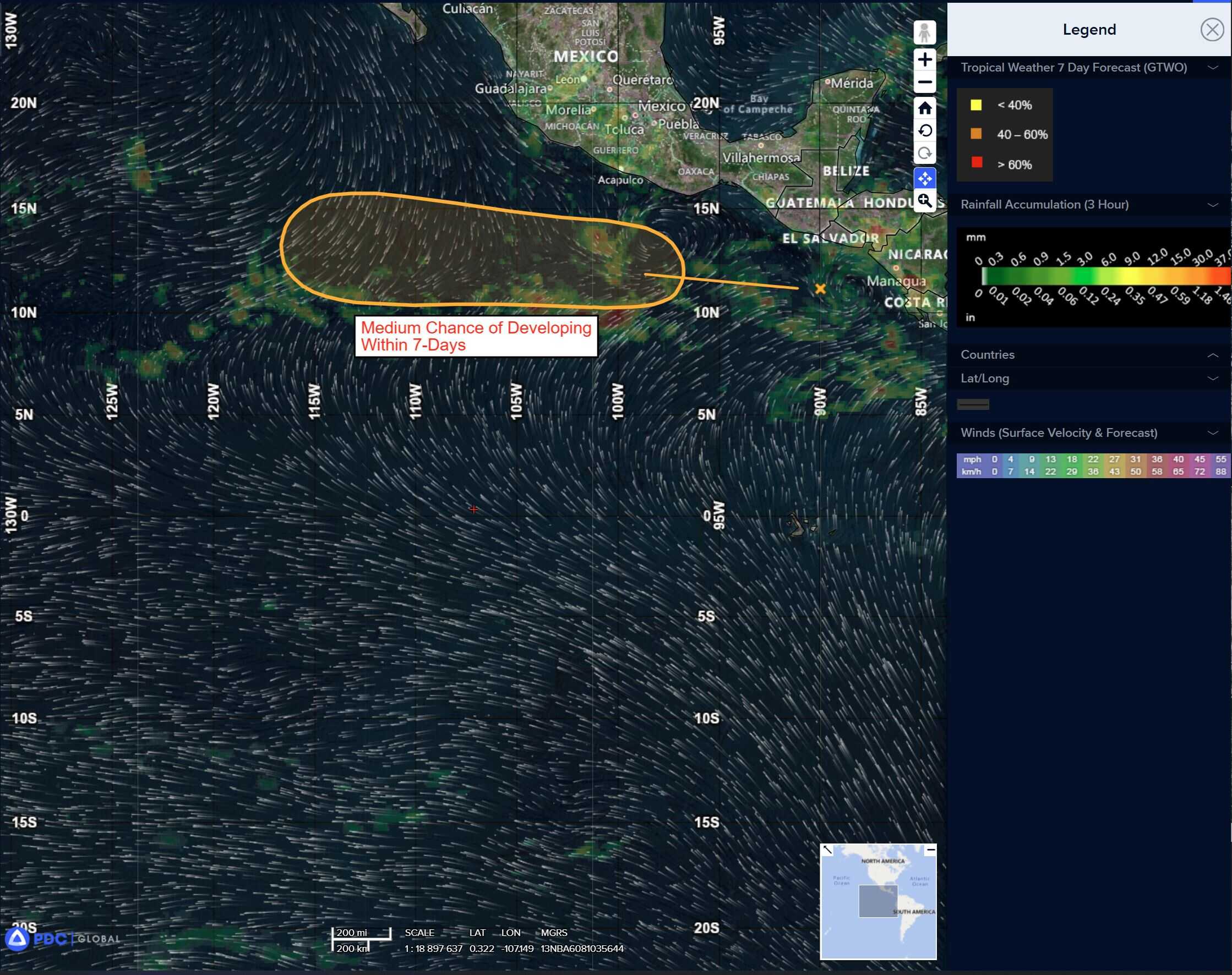
>>> A surface trough located a couple of hundred miles southwest of Guatemala is producing disorganized showers and thunderstorms.
Environmental conditions appear conducive for slow development of this system, and a tropical depression could form by the latter portion of this week as it moves generally westward at 10 to 15 mph.
* Formation chance through 48 hours…low…10 percent
* Formation chance through 7 days…medium…50 percent
Central Pacific Ocean: There are no Tropical Cyclones
Tropical cyclone formation is not expected during the next 7 days.
Western Pacific, Indian Ocean, and adjacent Seas:
Western Pacific
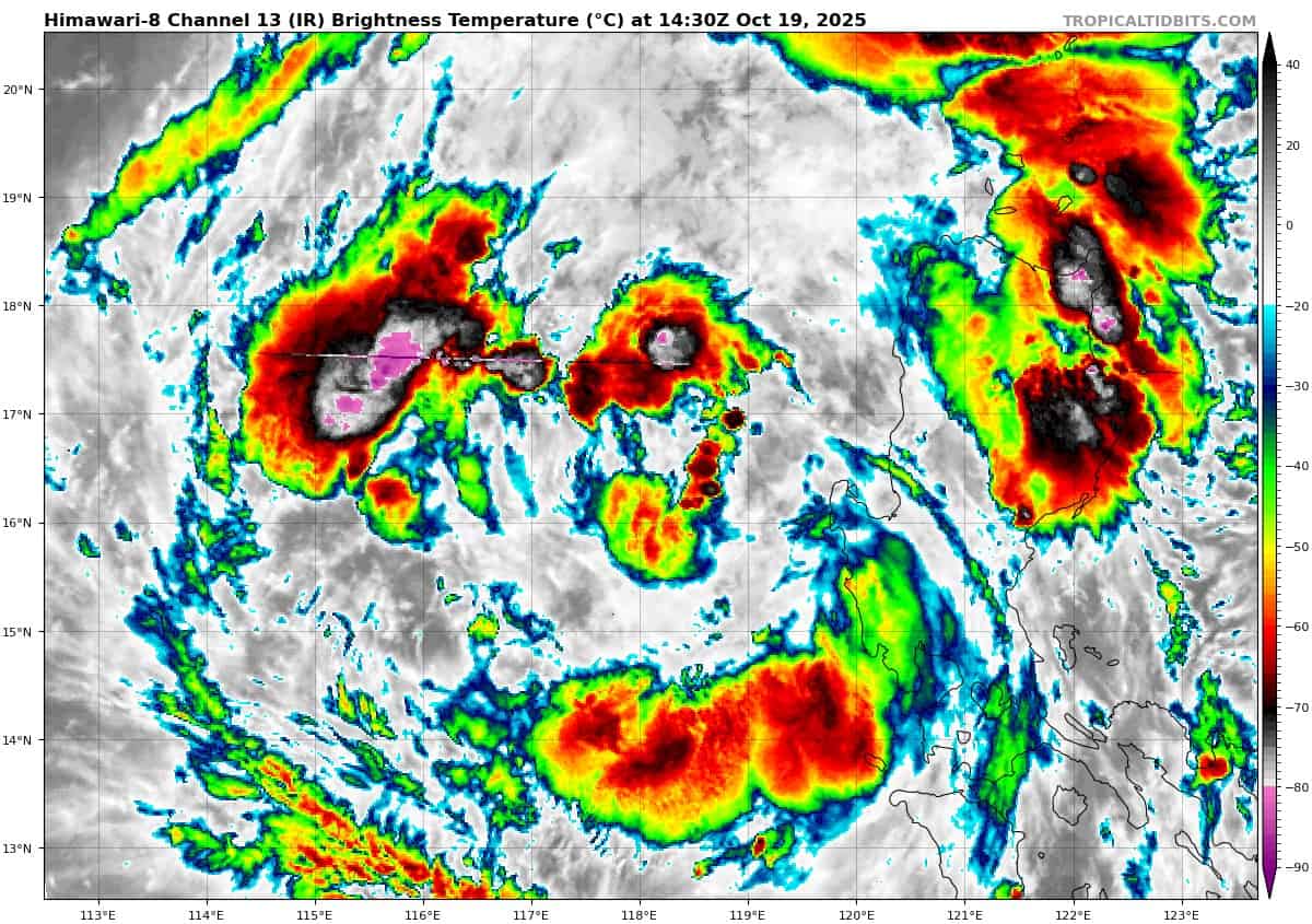
Tropical Cyclone 03W (Fengshen)
According to the JTWC warning number 8, sustained winds are 40 knots with gusts to near 50 knots
Fengshen has been downgraded to a tropical depression, and earlier positions have been reanalyzed to reflect a lower intensity. Primarily, these changes have been made to reflect the 191234z ascat-b bullseye pass, which revealed a very small rotation west of the Lingayen Gulf, with maximum associated winds of just 25 knots, these being restricted to the eastern sections of the rotation. The western portion showed winds of less than 15 knots, while winds of 30-35 knots were present far to the north, streaming southwestward out of the Luzon Strait.
Animated enhanced infrared (eir) satellite imagery shows collapsing convection to the south, and isolated pockets of moderate convection starting to form to the northwest and west of the low level circulation center (llcc).
The environment remains favorable overall, though a reduction in upper-level outflow, particularly the choking off of most of the equatorward component and the influx of some elevated mid-level easterly shear, has put a damper on things for the time being.
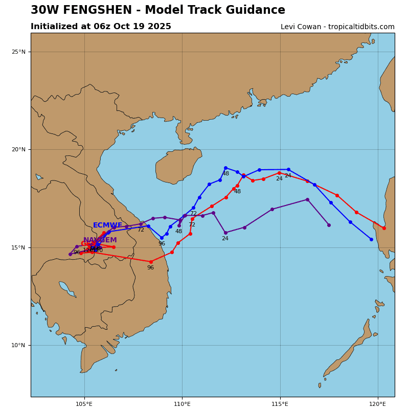
Tropical depression 30W is forecast to track northwestward along the southwestern periphery of the str to the northeast over the next 12 to 24 hours, then turn sharply west as the ridge extends westward into southern china. After 24 hours, the system slows quickly as it moves into a weak and competing
steering pattern between ridging to the west and east in the
upper-levels, while strong northeasterly flow associated with a cold surge will serve as a buffer along the coast of southern China and block further westward movement.
By 36 hours, the ridge of northern Laos builds, setting up a deep northeasterly flow through the atmospheric column, forcing TD 30W to make a rapid turn towards the southwest. The system will then accelerate southwestward through the remainder of the forecast period, making landfall along the central coast of Vietnam around 84 hours.
The recent motion of TD 30W has kept it within fairly close proximity to western Luzon, which has disrupted the vortex consolidation process. Combined with the loss of the equatorward outflow channel, this has led to an overall weakening of the system. However, the most recent frames of water vapor imagery show upper-level poleward outflow is already starting to improve, flowing into the base of a jet max east of Shanghai. And the latest frames of shortwave infrared (swir) suggest the llcc may be rapidly consolidating, now that it’s move offshore enough to establish uninterrupted flow on the eastern flank.
Global models indicate the outflow will steadily improve, while shear remains relatively low, through 36 hours, allowing the system to steadily intensify to a peak of 60 knots by 36 hours. After this point in the forecast, shear is expected to increase, and the system will suffer from dry air entrained into the core, resulting in rapid weakening through 72 hours. The system will make landfall as a weak tropical storm, and dissipate over the mountains of southern Vietnam by 96 hours.
South Indian Ocean
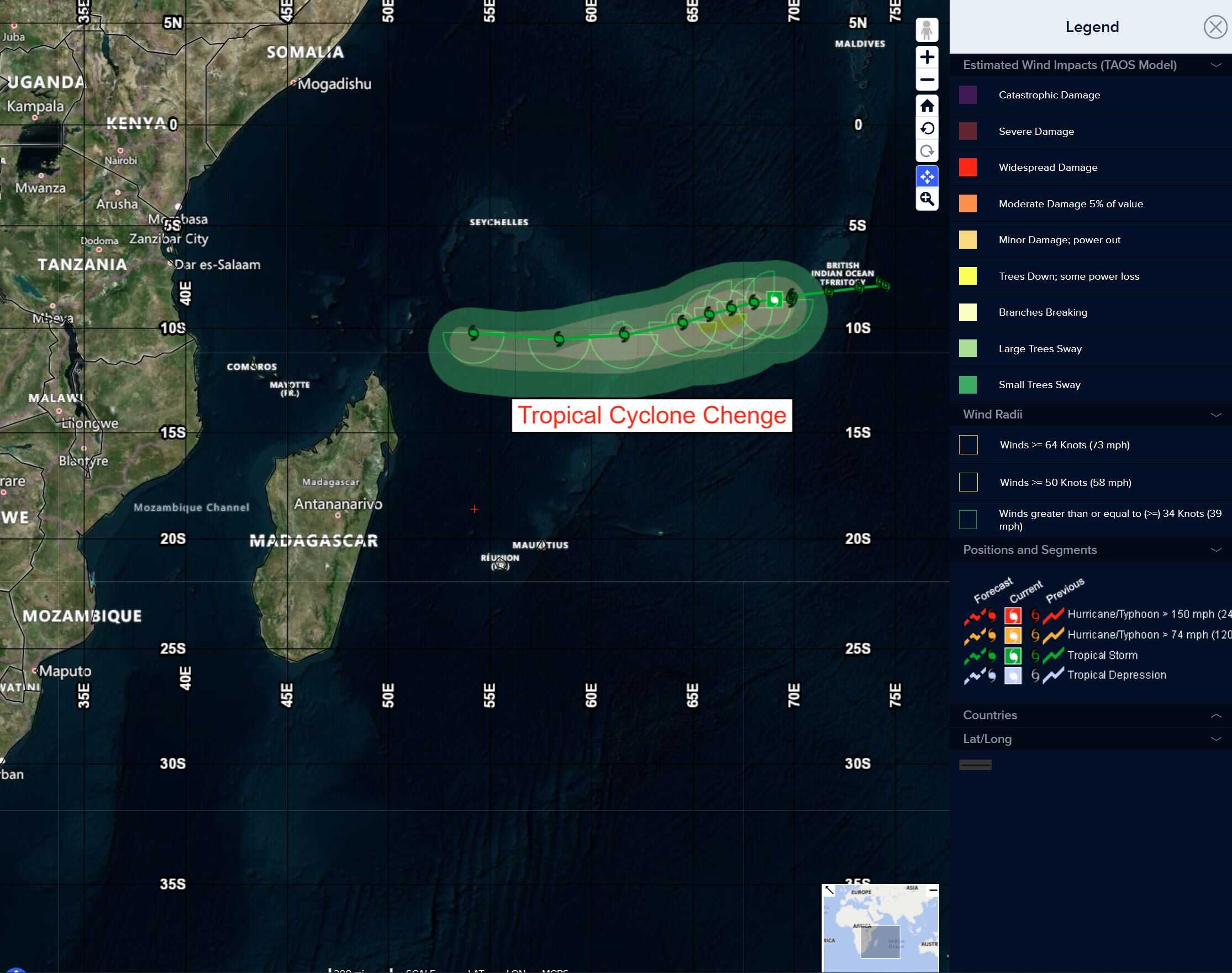
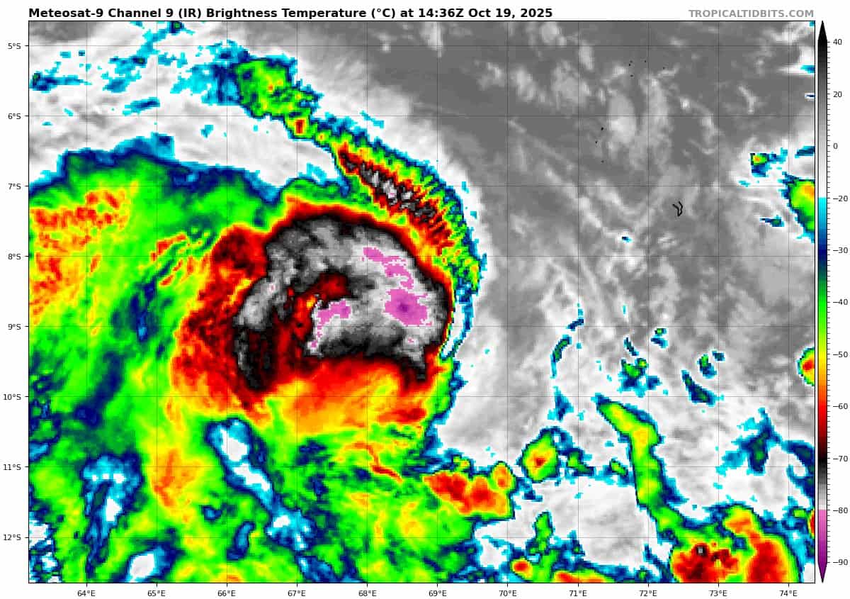
Tropical Cyclone 04S (Chenge)
According to the JTWC warning number 8, sustained winds are 40 knots with gusts to near 50 knots
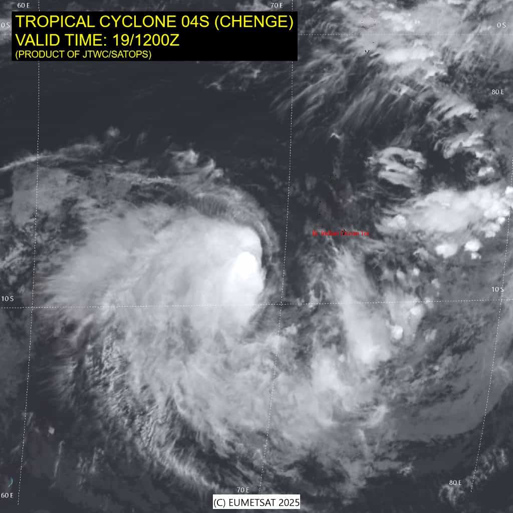
Animated enhanced infrared (eir) satellite imagery continues to depict a partially exposed low level circulation center (llcc), with flaring convection beginning to reform along the western flank
of the llcc, continuing the cycle seen over the past couple days.
Shear remains relatively high however, and along with the dry air
to the east, is hindering vortex consolidation and intensification.
A 190813z gmi 36ghz microwave image revealed a small but well defined low emissivity region marking the llcc, with a large
area of deep moisture and convection forming convective bands along the entire western half of the circulation. The eastern half for the most part contains only shallow banding features wrapping into the llcc, due to the presence of the dry mid-level air.
Environmental conditions remain steady, and marginally favorable, with warm ssts, and strong poleward outflow offset by persistent moderate easterly shear.
Tropical cyclone 04S has continued to track westward along the northern side of the str over the past 12 hours. The system has slowed down however, as a weakness has developed in the ridge due to passage of the a trof far to the south. The weakened steering gradient is expected to persist for another 12 to 24 hours, before the ridge builds back in and moves slowly westward, though track speeds are expected to remain fairly low through 72 hours.
After 72 hours, the ridge is forecast to strengthen and push westward in response to strong trofing over the Mozambique Channel, which will result in a flatter, more westward and slightly faster trajectory for TC 04S through the end of the forecast period.
The system has maintained its current intensity for the last couple of forecasts, as there have been no major changes in the overall environment. However, the latest cimss amv analysis depicts strengthening poleward outflow, around a building 200mb ridge to the east. The improved outflow environment should offset the moderate easterly shear just enough to allow for a brief period of intensification, up to 45 knots by 24 hours.
But the environment will quickly change and by 36 hours, shear is expected to increase, accompanied by an influx of dry mid-level air and convergent flow aloft, the combined effects of which will start a slow weakening trend from which 04S will not be able to recover. The system will slowly spin down after 48 hours and begin to dissipate by the end of the forecast period.
>>> There’s an area of disturbed weather being referred to as Invest 95S…which is located approximately 591 NM north of Cocos Islands.
Animated enhanced infrared satellite imagery depicts a broad low level circulation with deep convection sheared over the western semicircle. A 191851z atms 89 ghz microwave image shows formative banding over the northwestern quadrant and a weakly defined llcc.
Environmental analysis reveals a marginal environment for development with fair poleward outflow, moderate to high vertical wind shear of 20-25 knots, and warm sea surface temperatures of 29-30 c.
Global models are in agreement on the slow intensification and the southward track of the system over the next two days.
Maximum sustained surface winds are estimated at 20 to 25 knots.
The potential for the development of a significant tropical cyclone within the next 24 hours is low.