
")
Current Snapshot
For all the latest updates visit: DisasterAWARE
GOES19-TAW-13-900x540latest
erin
161432_earliest_reasonable_toa_34
161432INTQPF_sm

05L_tracks_latest
2
7
1000×1000
By PDC’s Senior Weather
Specialist Glenn James

The Pacific Disaster Center’s (PDC Global) Saturday, August 16, 2025, Tropical Cyclone Activity Report…for the Atlantic Ocean, the Caribbean Sea, and the Gulf of America
Current Tropical Cyclones:
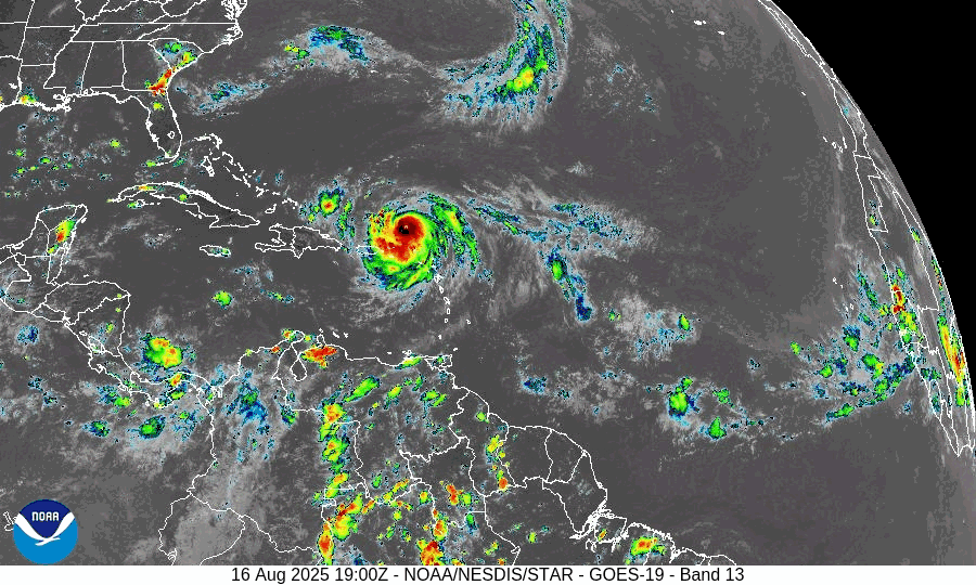
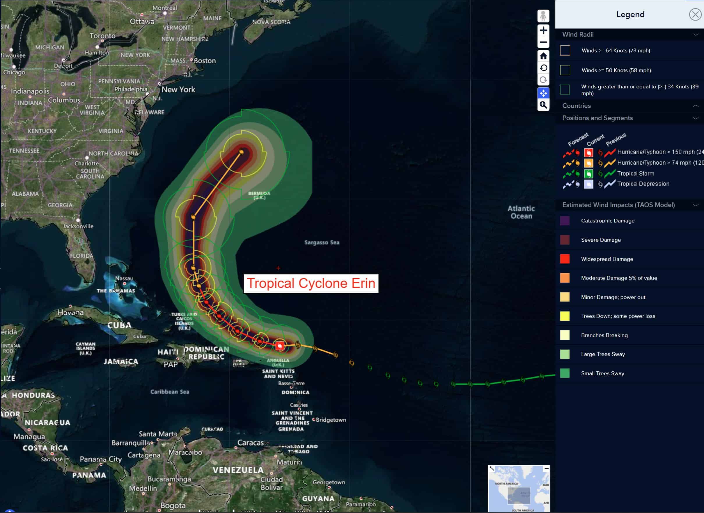
Tropical Cyclone Erin…is located about 145 miles north-northeast of San Juan, Puerto Rico
Atlantic Ocean
Tropical Cyclone Erin
ERIN STILL A FORMIDABLE CATEGORY 4 HURRICANE UNDERGOING STRUCTURAL CHANGES…HEAVY RAINS AND GUSTY WINDS OCCURING OVER PUERTO RICO AND THE VIRGIN ISLANDS
According to the NHC advisory number 23
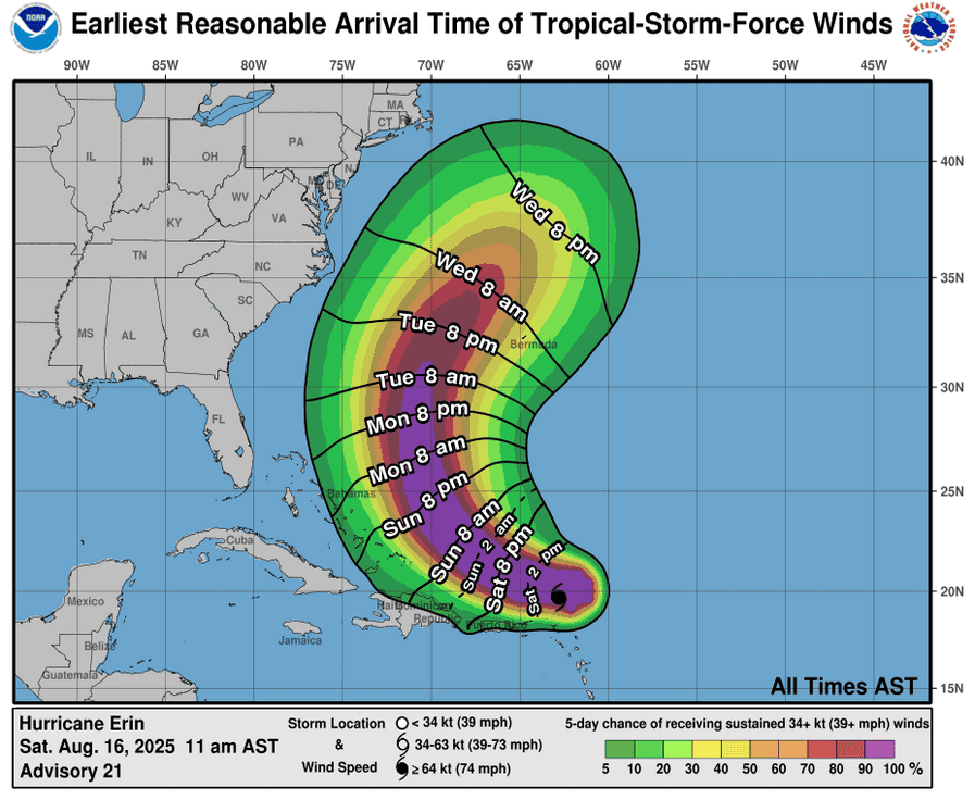
Erin is moving toward the west-northwest near 14 mph (22 km/h). This motion is expected to continue through Sunday with a decrease in forward speed. A turn more northward is expected to occur on Monday into Tuesday. On the forecast track, the center of Erin is expected to begin moving away from the Virgin Islands and Puerto Rico on Sunday, and pass to the east of the Turks and Caicos Islands and the southeastern Bahamas Sunday night and Monday. NOAA Hurricane Hunter and Air Force Reserve reconnaissance data indicates that maximum sustained winds have decreased to near 140 mph (220 km/h) with higher gusts. Erin is a category 4 hurricane on the Saffir-Simpson Hurricane Wind Scale. Fluctuations in intensity are expected over the next day or two due to inner-core structural changes with Erin. Hurricane-force winds extend outward up to 25 miles (35 km) from the center and tropical-storm-force winds extend outward up to 205 miles (335 km).
HAZARDS AFFECTING LAND
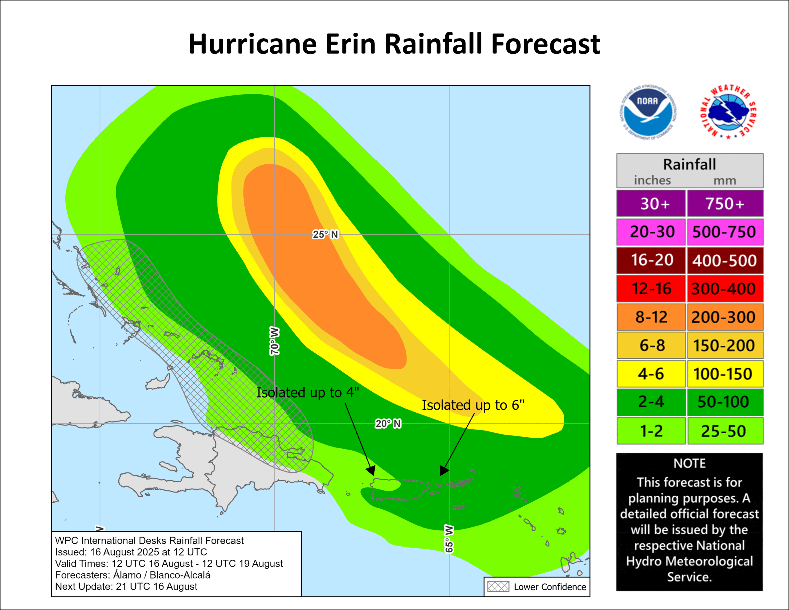
RAINFALL: The outer bands of Erin will continue to produce areas of heavy rainfall through Sunday across the northern Leeward Islands, the Virgin Islands, and Puerto Rico. Rainfall totals of 2 to 4 inches, with isolated totals of 6 inches, are expected. Locally considerable flash and urban flooding, along with landslides or mudslides, are possible.
WIND: Tropical storm conditions are possible within the watch area in the Leeward Islands through tonight, and in the watch area in the Turks and Caicos Islands beginning on Sunday. Squalls with wind gusts to tropical-storm force may occur elsewhere over portions of the northern Leeward Islands, Virgin Islands, and Puerto Rico through Sunday. Squalls with wind gusts to tropical-storm force may also occur over the southeastern Bahamas beginning on Sunday.
SURF: Swells generated by Erin will affect portions of the northern Leeward Islands, the Virgin Islands, Puerto Rico, Hispaniola, and the Turks and Caicos Islands through the weekend. These swells will spread to the Bahamas, Bermuda, and the east coast of the United States by early next week. These rough ocean conditions will likely cause life-threatening surf and rip currents.
Northwestern Atlantic
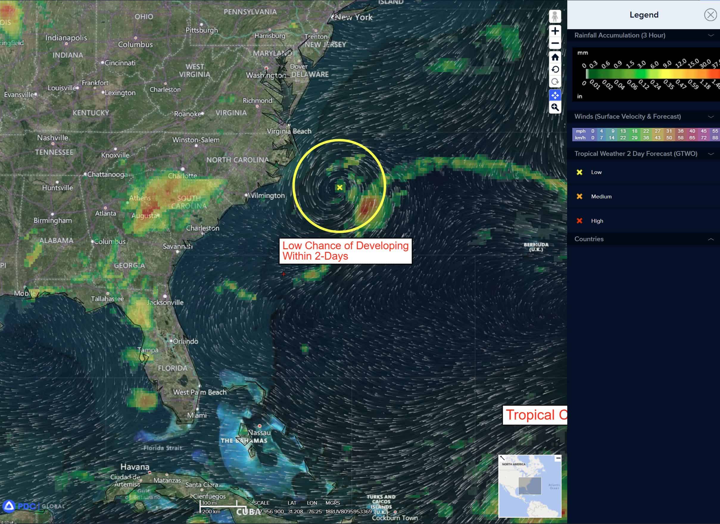
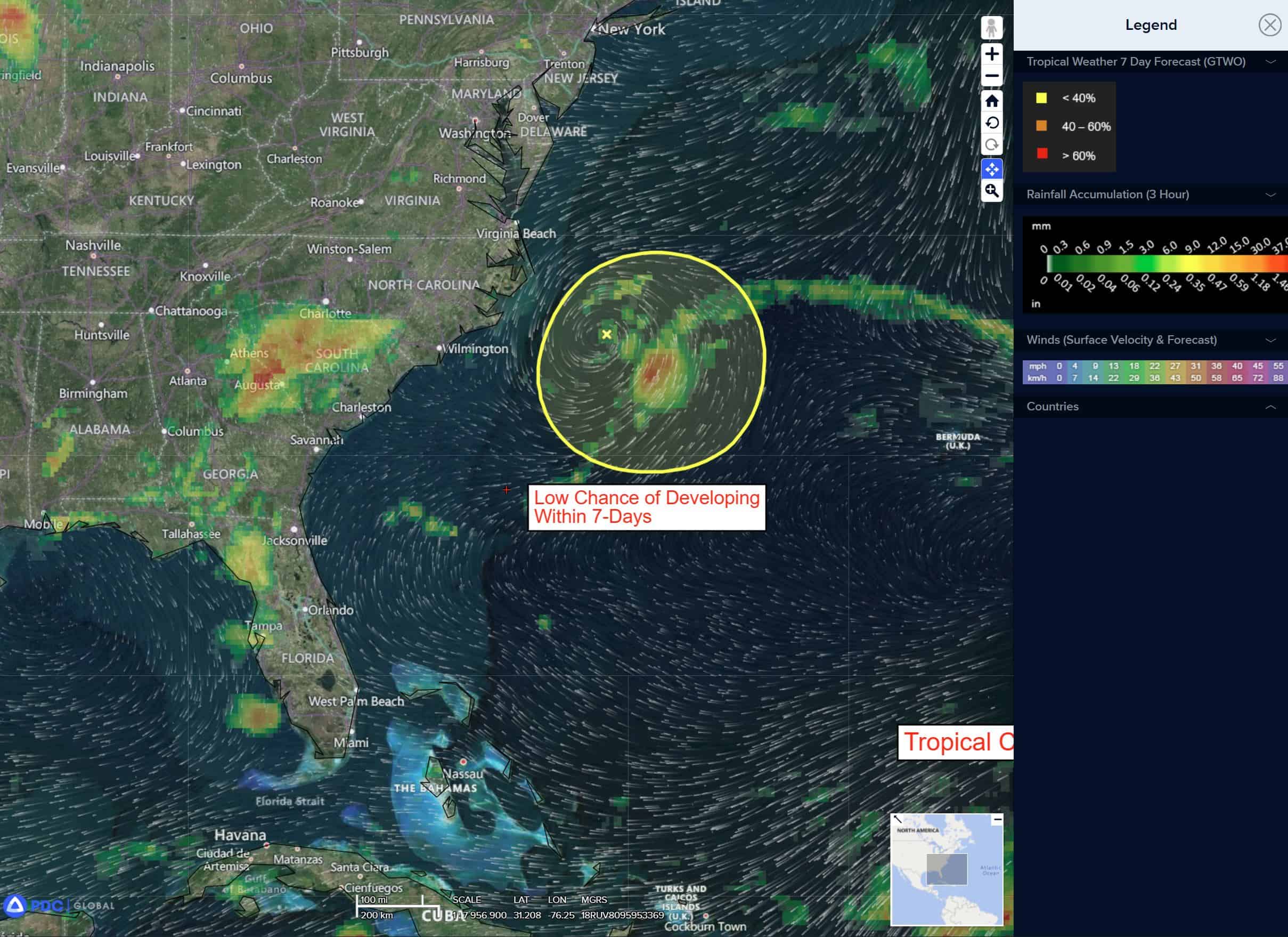
>>> The area of low pressure located a couple hundred miles off the coast of North Carolina has not become any better organized over the past 24 hours, with limited disorganized shower and thunderstorm activity displaced well to the east of the center. Some slight development of this system is still possible over the next day or so while it moves little over the warm waters of the Gulf Stream. By Monday, environmental conditions are expected to become unfavorable for further development.
* Formation chance through 48 hours…low…10 percent
* Formation chance through 7 days…low 10 percent
Central Tropical Atlantic
>>> An area of low pressure could form over the central tropical Atlantic during the middle to latter portion of next week from a westward moving tropical wave. Some subsequent development could occur as the system moves westward to west-northwestward at around 15 mph.
* Formation chance through 48 hours…low…near 10 percent
* Formation chance through 7 days…low 20 percent
Caribbean Sea: There are no active tropical cyclones
Tropical cyclone formation is not expected during the next 7-days.
Gulf of America: There are no active tropical cyclones