Tropical Cyclone 07E (Gil)
GIL WEAKENING…EXPECTED TO BECOME POST-TROPICAL ON SUNDAY
According to the NHC Advisory number 12

")

By PDC’s Senior Weather
Specialist Glenn James

The Pacific Disaster Center’s (PDC Global) Saturday, August 2, 2025, Tropical Cyclone Activity Report…for the Pacific Ocean, the Indian Ocean, and adjacent Seas
Current Tropical Cyclones:
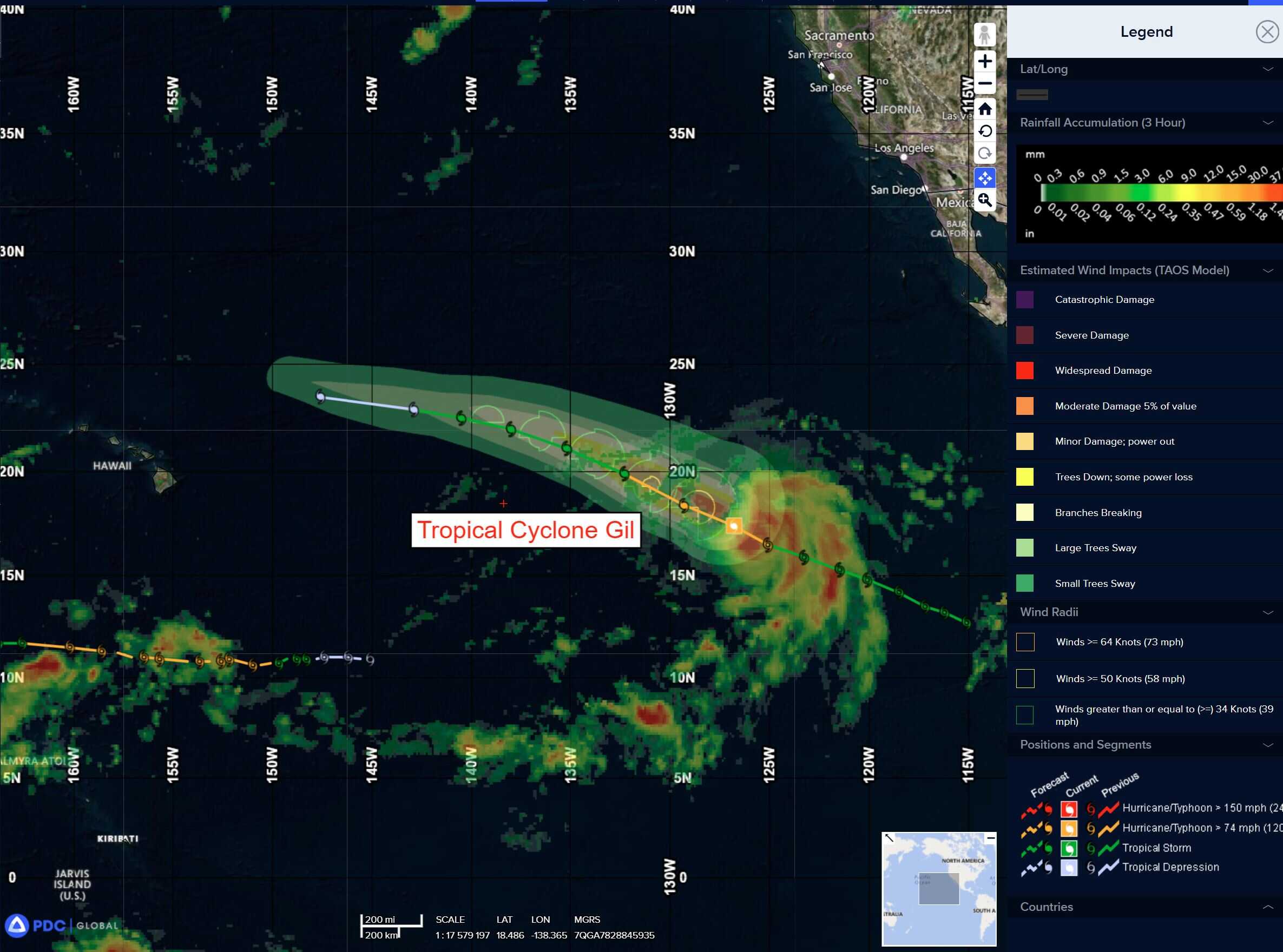
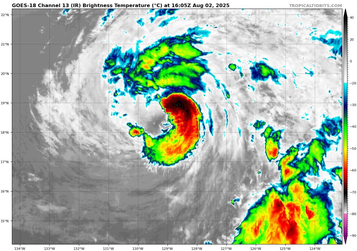
Tropical Cyclone (Gil)…is located about 1440 miles west of the southern tip of Baja California
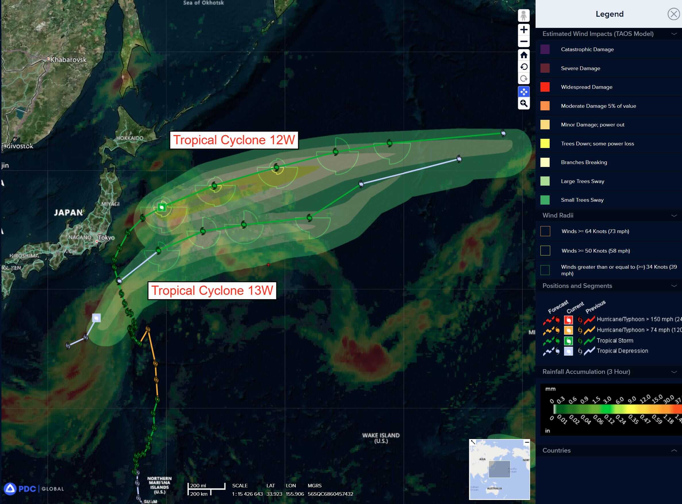
Tropical Cyclone 12W (Krosa)…is located approximately 441 NM east of Misawa, Japan
Tropical Cyclone 13W (Bailu)…is located approximately 159 NM southeast of Yokosuka, Japan
Northeast Pacific Ocean:
Tropical Cyclone 07E (Gil)
GIL WEAKENING…EXPECTED TO BECOME POST-TROPICAL ON SUNDAY
According to the NHC Advisory number 12
Gil is moving toward the west-northwest near 21 mph (33 km/h). A gradual decrease in forward speed is expected during the next couple of days, with a turn toward the west forecast by Monday. Maximum sustained winds have decreased to near 65 mph (100 km/h) with higher gusts. Additional weakening is forecast, and Gil is expected to become post-tropical on Sunday. Tropical-storm-force winds extend outward up to 140 miles (220 km) from the center.
Central East Pacific:
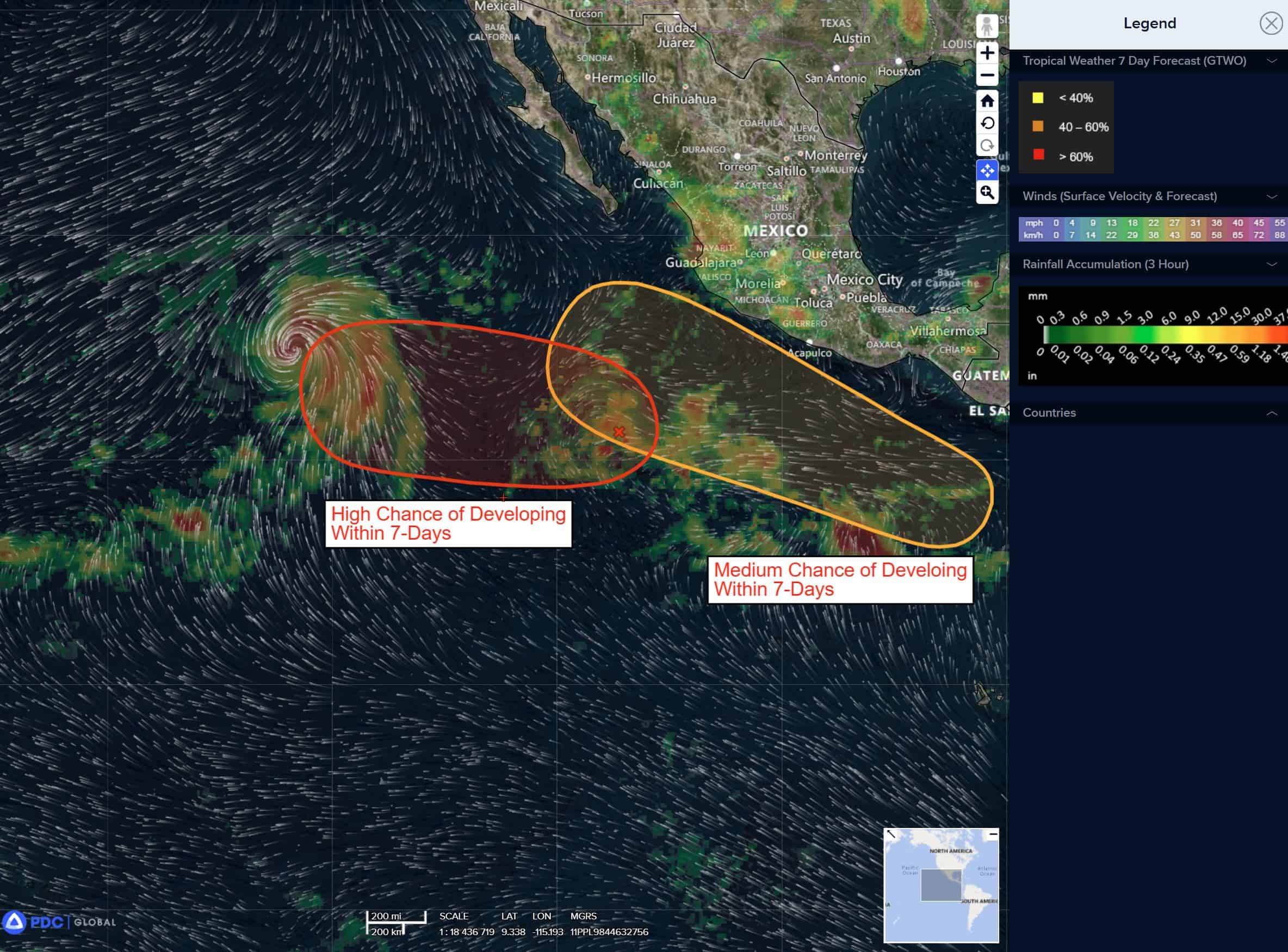
Invest 90E
>>> Disorganized showers and thunderstorms located well west-southwest of the southwestern coast of Mexico are associated with a broad area of low pressure. Environmental conditions are conducive for development of this system, and a tropical depression is expected to form late this weekend or early next week while the system moves west-northwestward at 10 to 15 mph.
* Formation chance through 48 hours…high…80 percent
* Formation chance through 7 days…high…90 percent
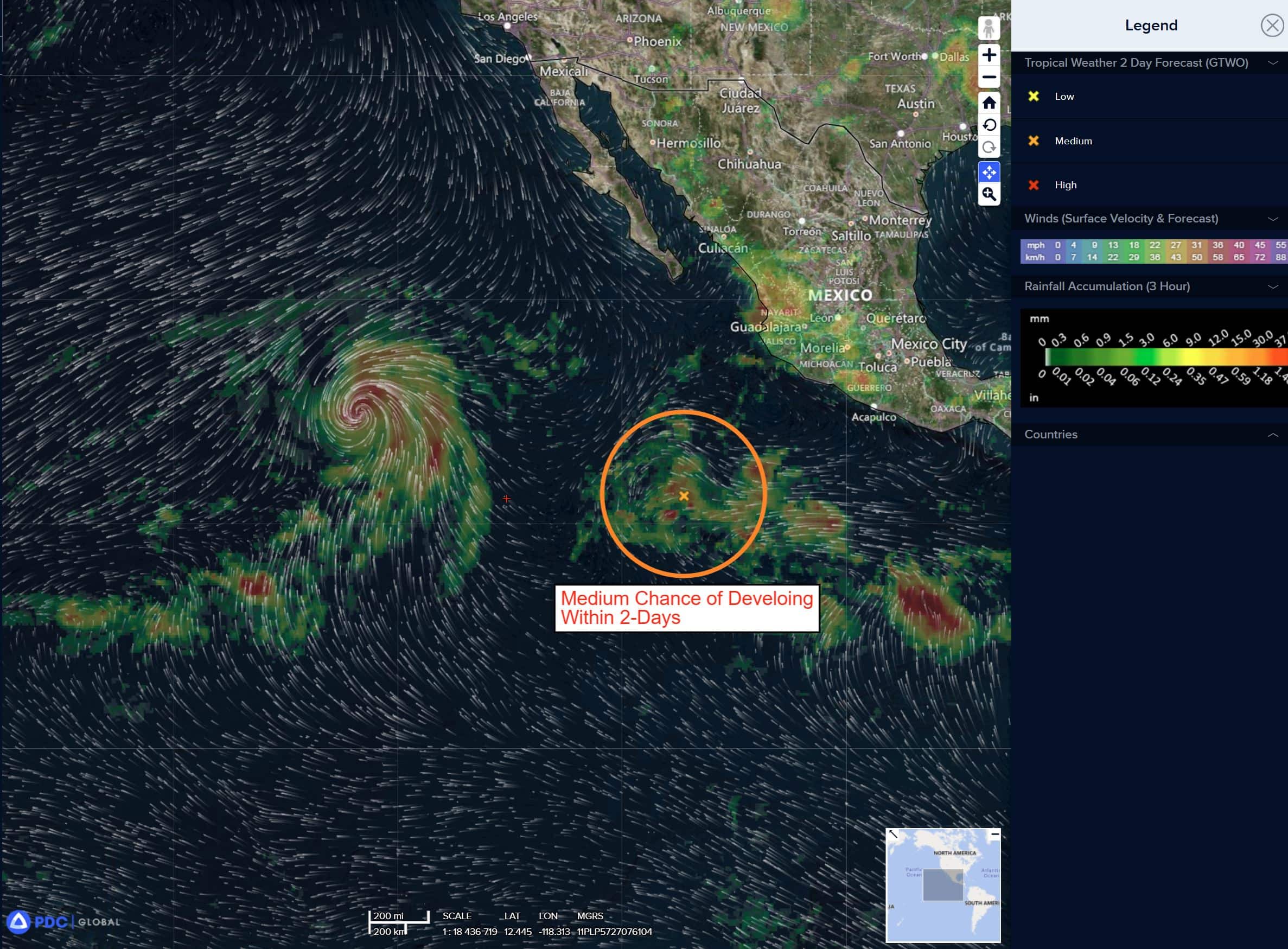
South of Southern Mexico:
>>> An area of low pressure is forecast to form offshore of the coast of Central America and southern Mexico by the middle part of next week. Environmental conditions appear conducive for some development, and a tropical depression could form late next week as the system moves generally west-northwestward at 10 to 15 mph.
* Formation chance through 48 hours…low…near 0 percent
* Formation chance through 7 days…medium…50 percent
Central Pacific Ocean: There are no Tropical Cyclones
Tropical cyclone formation is not expected during the next 7 days.
Western Pacific, Indian Ocean, and adjacent Seas:
Western Pacific
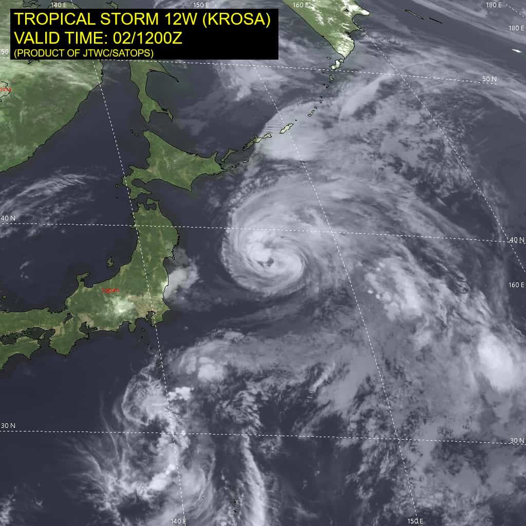
Tropical Cyclone 12W (Krosa)
According to the JTWC warning number 42 sustained winds are 50 knots with gusts to near 65 knots
Animated enhanced infrared (eir) satellite imagery indicates that tropical storm 12W maintains a symmetrical and well-organized
structure, although the associated convection continues to warm and weaken. An ascat-b bullseye pass reveals an increasingly asymmetric wind field, but a well-defined inner-core of light winds and storm-force winds to the south and southeast of the tightly defined low level circulation center (llcc).
Environmental conditions are rapidly deteriorating, with rapidly cooling ssts, though the moderate to high southerly shear is offset for the moment by the strong poleward outflow, allowing
the vortex to remain coupled.
Tropical storm 12W is forecast to track east-northeastward through the forecast period, along the northern side of a deep str that shifts southwestward through 48 hours, then along the northern edge of a separate str pushing west of the dateline through 72 hours. Track speeds are expected to increase up to 48 hours, then slow slightly as the system moves through a relatively weaker steering gradient as the primary steering
influence shifts from the ridge east of Japan to the ridge moving
across the dateline.
As mentioned above, the southwesterly shear vector is currently in phase with track of TS 12W, reducing the relative shear, and allowing the system to maintain a relatively aligned and coupled vortex. This has allowed TS 12W to maintain intensity over the past 24 hours even in the face of otherwise unfavorable deep-layer shear. The system has also been moving over a tongue of warm waters but has now moved away from those and is currently moving along the gradient between the Kuroshio Current and much cooler waters to the north and east.
The system is forecast to maintain intensity for another 12 hours, but as it continues tracking northeastward, the shear vector will become increasingly out of phase with the storm motion, with the result of rapidly increasing deep-layer shear. This will usher in dry air into the core of the system as well, leading to steady weakening through the remainder of the forecast. The system will begin extratropical transition (ett) by 48 hours, with ett expected to complete no later than 72 hours, but likely as early as 60 hours.
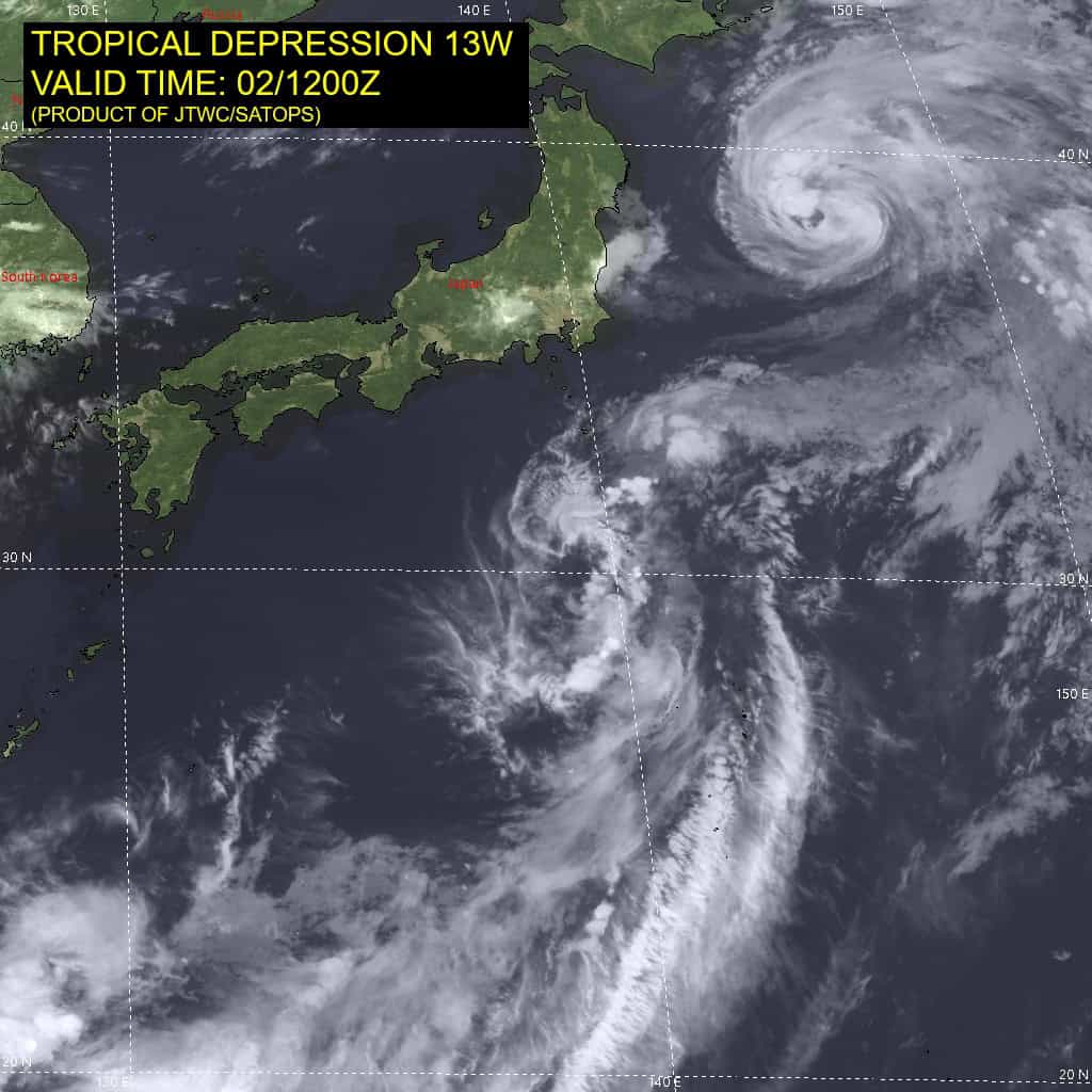
Tropical Cyclone 13W (Bailu)
According to the JTWC warning number 5 sustained winds are 35 knots with gusts to near 45 knots
Animated enhanced infrared (eir) satellite imagery depicts a highly asymmetric and disorganized system, positioned on the northern side of an elongated band of elevated southwesterly flow extending far to the southwest up to TS 12W. The eir loop also depicts a well-defined and exposed low level circulation to the northwest of the assessed initial position. This is not the primary low level circulation center (llcc) of TD 13W, but rather represents the secondary spinner which was tracked moving rapidly northward to the east of the primary circulation over the past 12 hours.
It is currently moving southeast towards the primary circulation. A ascat-b pass also shows this setup, with the secondary circulation well-defined in the scatterometer pass, but surrounded by relatively light (less than 20 knot) winds, while the area being tracked as the center is reflected in the ascat pass as a small wave feature to the southeast of the secondary spinner.
Higher winds up to 30-35 knots are present close to the this region and wrapping into the center, though the western side of the circulation does not appear closed and with much lighter winds.
Environmental conditions remains overall favorable, with low vws, warm ssts and good poleward outflow. However, these are offset by the clear asymmetries and vortex misalignment as seen in the ascat data.
Tropical depression 13W is forecast to continue tracking northeastward for the next 24 hours along the western side of the deep ridge to the east. After 24 hours, the track will flatten to a more eastward path as the ridge rapidly shifts westward. After 72 hours the system once again turns northeastward as a separate str pushes west across the dateline and becomes the dominant steering influence. Track speeds slow briefly after 72 hours due to a weakened steering gradient as the steering influence transitions.
In terms of intensity, it remains highly unlikely that TD 13W will be able to intensify much under the current multi-vortex, highly asymmetric conditions. If, as some of the high-resolution models suggest, the multiple vortices can merge and align, then intensification can occur. the hafs-a and hwrf both suggest this vortex alignment process will occur within the next 12 to 18 hours, thereby setting the stage for intensification under
otherwise favorable conditions of low southerly shear and warm
ssts.
However, there will be limited time under favorable shear conditions, and by 72 hours, the combination of increased shear and dry mid-level air intrusion will begin a slow weakening phase that will continue through the end of the forecast. By 96 hours, TD 13W will begin extratropical transition (ett) with completion of ett by 120 hours.
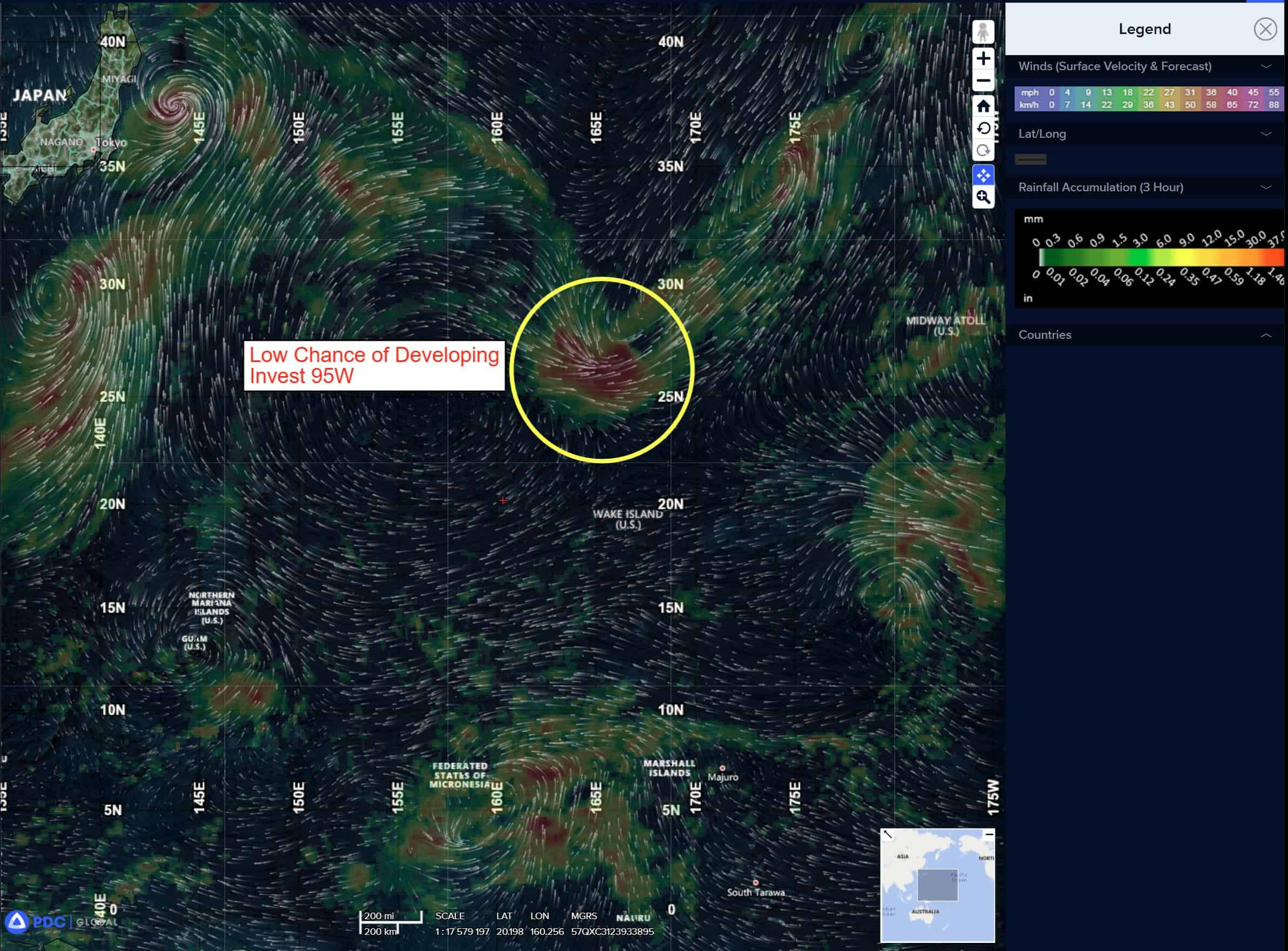
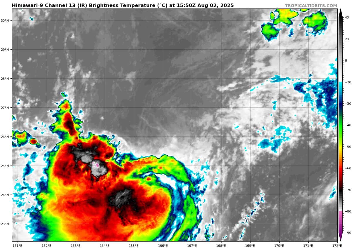
>>> There’s an area of disturbed weather being referred to as Invest 95W, which is located approximately 386 NM north of Wake.
Animated enhanced infrared satellite imagery (eir) depicts a fully exposed low level circulation center (llcc) with flaring convection displaced to the south due to persistent northerly flow aloft. An ascat reveals 15-20 knot winds surrounding a small llcc, with some isolated pockets of higher winds, particularly under the convection to the south.
95W has pinched off from the southern end of a shearline or weak frontal system over the last 24 hours and moved into a slightly more favorable upper-level environment, allowing for the recent uptick in convective activity seen in the eir loop.
Environmental analysis for the area indicates marginally favorable conditions for development with moderate to high vertical wind shear (20-30 kts) offset by warm sea surface temperatures and moderate equatorward outflow aloft.
Global deterministic models are in a fair agreement that the area of convection 95W will track southwest slowly over the next 24 to 36 hours before eventually turning poleward. Global models are currently mixed as to whether 95W will intensify. The GFS shows very weak intensification, while the remainder of the models do not. ECENS and GEFS ensemble guidance also show mixed results, with the ECENS being slightly more aggressive than the GEFS in developing the system.
Maximum sustained surface winds are estimated at 18 to 23 knots.
The potential for the development of a significant tropical cyclone within the next 24 hours is upgraded to medium.