
")
Current Snapshot
For all the latest updates visit: DisasterAWARE
40
1800×1080
wpac
10W_241200sair
11W_241200sair
12W_241200sair
By PDC’s Senior Weather
Specialist Glenn James

The Pacific Disaster Center’s (PDC Global) Thursday, July 24, 2025, Tropical Cyclone Activity Report…for the Pacific Ocean, the Indian Ocean, and adjacent Seas
Current Tropical Cyclones:
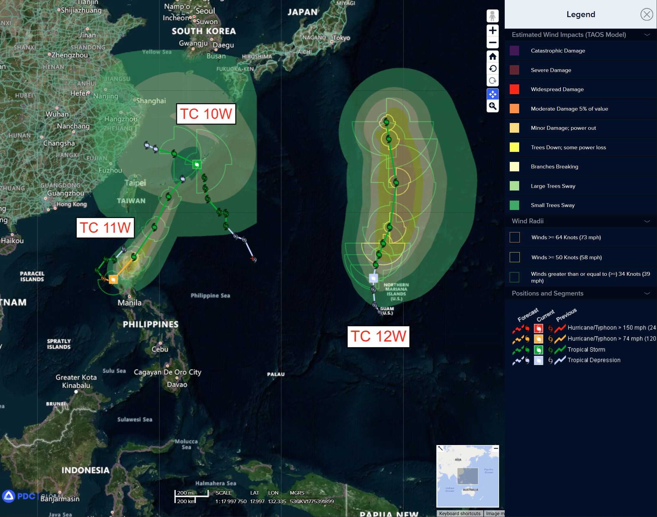
Tropical Cyclone 10W (Francisco)…is located 153 NM northeast of Taipei, Taiwan
Tropical Cyclone 11W (Co-may)…is located 162 NM north of Manila, Philippines
Tropical Cyclone 12W (Krosa)…is located 211 north-northwest of Andersen AFB
Northeast Pacific Ocean: There are no Tropical Cyclones
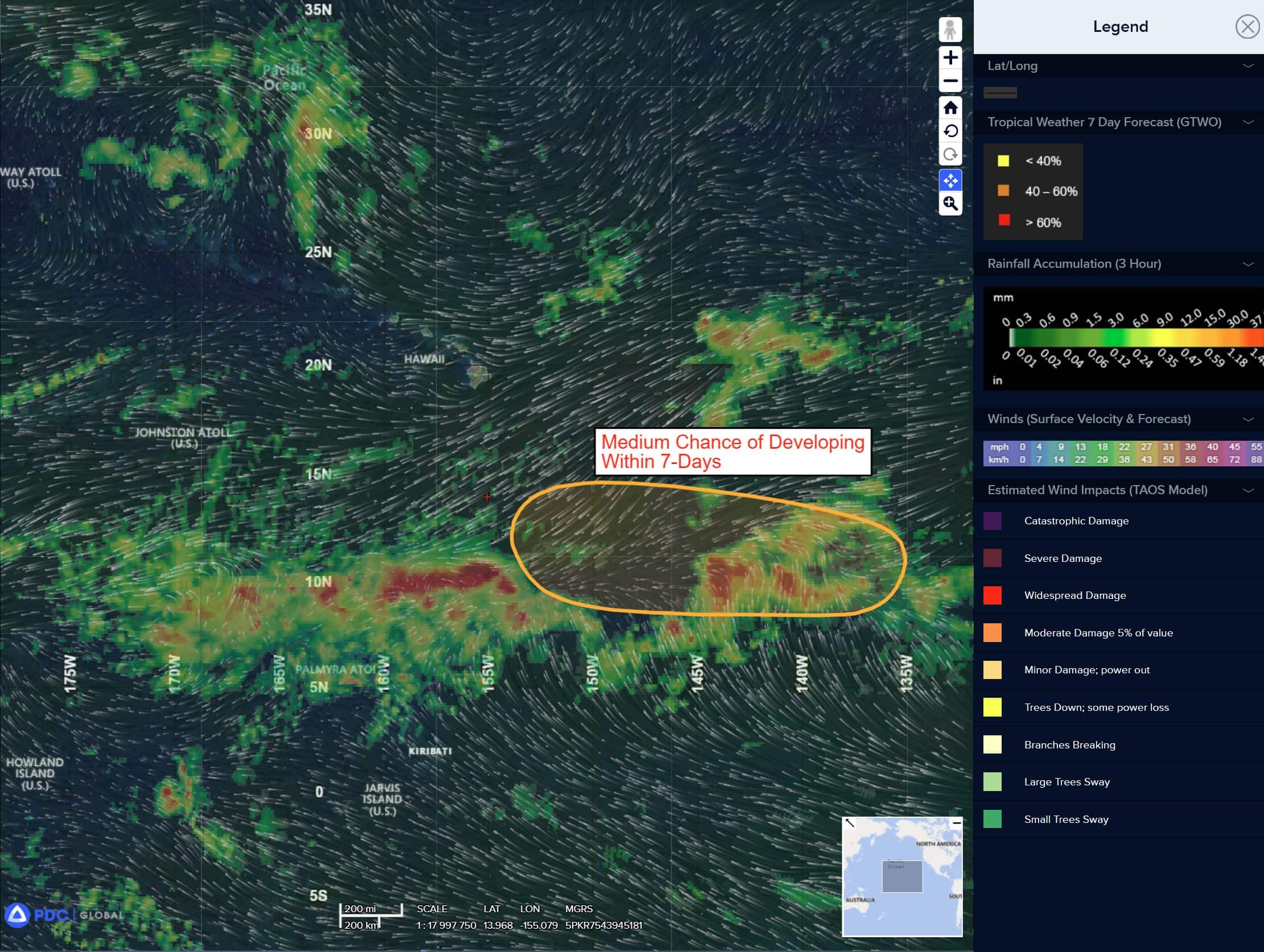
Well Southeast of the Hawaiian Islands:
Disorganized showers and thunderstorms associated with a broad trough of low pressure located well southeast of the Hawaiian Islands continue. Some gradual development of this system is possible, and a tropical depression could form late this weekend or early next week as it moves generally westward at 10 to 15 mph across the far western portion of the eastern Pacific and into the Central Pacific basin.
* Formation chance through 48 hours…low…10 percent
* Formation chance through 7 days…medium…40 percent
Central East Pacific:
>>> An area of low pressure is forecast to form offshore of the southwestern coast of Mexico early next week. Thereafter, environmental conditions appear conducive for some development as the system moves generally west-northwestward at 10 to 15 mph.
* Formation chance through 48 hours…low…near 0 percent
* Formation chance through 7 days…low…20 percent
Central Pacific Ocean: There are no Tropical Cyclones
Well Southeast of the Hawaiian Islands:
An area of low pressure is forecast to develop well to the southeast of the Hawaiian Islands by this weekend. Thereafter, some gradual development is possible and a tropical depression could form while the system moves generally westward at 10 to 15 mph.
* Formation chance through 48 hours…low…near 0 percent
* Formation chance through 7 days…medium…40 percent
Western Pacific, Indian Ocean, and adjacent Seas:
Western Pacific
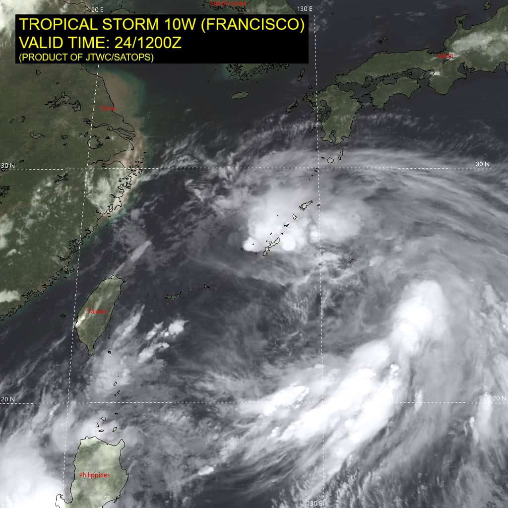
Tropical Cyclone 10W (Francisco)
According to the JTWC warning number 12 sustained winds are 35 knots with gusts to near 45 knots
Animated enhanced infrared (eir) satellite imagery depicts a mostly exposed low-level circulation center (llcc) associated with tropical storm 10W (Francisco), situated along the northeastern periphery of a broad monsoon gyre. The synoptic-scale gyre is oriented generally parallel to the southeastern coast of China, with the primary cyclonic center located southeast of Taiwan. The initial position is determined with medium confidence based on extrapolation from a 240915z wsfm mwi 37 ghz microwave imagery showing increasingly elongated low-level banding. Animated shortwave infrared imagery shows intermittent deep convective bursts north of the llcc, while the eastern semicircle of the broad circulation can be also identified utilizing a 241232z metop-b ascat image.
Environmental conditions remain marginally conducive for maintenance of intensity, characterized by warm sea surface temperatures (sst) and robust poleward outflow aloft. However, these positive factors are being offset by the presence of dry mid- to upper-level air entraining into the core and moderate (10-15 knot) vertical wind shear (vws).
TS 10W has made a northwestward turn and continues to accelerate, with translation speed currently assessed at 13 knots, as it responds to steering flow around the subtropical ridge (str) to the north and the evolution of the synoptic monsoon gyre it is embedded in. The gale-force wind field of the system extends out to approximately 200 NM, primarily throughout the northeastern quadrant. The radius of maximum winds (rmw) remains at 135 NM.
Over the next 36 hours, interaction with an increasingly hostile thermodynamic environment, including deep-layer dry air intrusion and increasing vws, will contribute to a steady weakening trend, leading to an eventual dissipation. By 36 hours, the system is anticipated to become increasingly deformed, losing deep convective organization as core vorticity dissipates. Subsequently, TS 10W will be fully absorbed into the larger-scale monsoon gyre circulation. During this transition, stronger gradient-induced winds associated with the gyre (25-30 knots) may persist, particularly along the southeastern China coast and extending eastward along the northern periphery of the gyre.
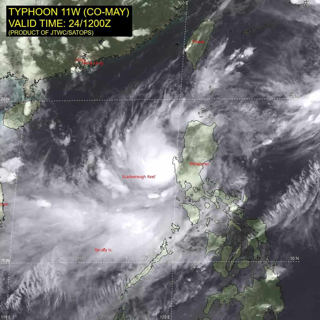
Tropical Cyclone 11W (Co-may)
According to the JTWC warning number 9 sustained winds are 45 knots with gusts to near 55 knots
Animated enhanced infrared (eir) satellite imagery depicts a central dense overcast (cdo) feature persisting over the last two hours, despite typhoon 11W (Co-may) proximity to land. deep convection associated with the system remained well organized, Given the predominantly favorable environmental conditions. Additional analysis reveals warm sea surface temperatures, enhanced upper-level divergence due to robust equatorward and poleward outflow channels, and plentiful mid- to upper-level moisture. Vertical wind shear (vws) remains low (5-10 knots), supporting maintenance of deep convection in the near term.
However, these factors are increasingly offset by frictional convergence and vorticity stripping associated with the proximity to land, particularly over the eastern semicircle of the circulation. The system continues to be embedded within the southwestern quadrant of a broad monsoon gyre, characterized by a synoptic-scale cyclonic circulation. The center of the gyre circulation is positioned southeast of Taiwan, with the axis generally aligned parallel to the southeastern china coastline.
TY 11W has completed a recurvature loop as it nears the west coast of Luzon, Philippines. while synoptic-scale parameters remain favorable for intensity maintenance, land interaction is beginning to dominate, impacting the low-level inflow and resulting in structural disruption of the vortex. Subsequently, a sharper decline in intensity is forecast as the core traverses northern Luzon on a northeastward trajectory. Shortly after 12 hours, the system is expected to reemerge over open water northeast of Luzon, with maximum sustained winds reducing to 45-50 knots.
Thereafter, TY 11W will track northeastward along the eastern flank of the gyre, skirting the northwestern periphery of a near-equatorial ridge (ner) to the southeast. By 36 hours, the system is forecast to gradually decouple from the deep convection, slow down, and begin integrating into the westerly component of the broader gyre. By the end of the forecast period, TY 11W is expected to transition into an open wave, with residual winds of 25-30 knots embedded within the monsoon gyre flow field.
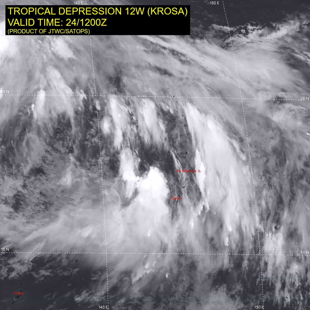
Tropical Cyclone 12W (Krosa)
According to the JTWC warning number 6 sustained winds are 40 knots with gusts to near 50 knots
Animated enhanced infrared (eir) satellite imagery depicts tropical depression 12W (Krosa) as struggling cyclone with a completely exposed low-level circulation center (llcc) while convection has remained largely dislocated away from the assessed center due to high wind shear values of over 30 knots. Near the surface, fragmented curved cloud lines have been observed wrapping around an asymmetric wind field over the past few hours. Aloft, animated water vapor imagery has continued to show moderate but
disorganized poleward outflow with no definitive associated support channels.
With regard to the environmental analysis, although sea surface temperatures remain warm and upper-level outflow moderate, vertical wind shear (vws) has removed supportive convective structures away from the central vortex.
TD 12W is expected to continue on a generally northward track throughout the 120 hour forecast period. in the short-term, a building subtropical ridge to the east will initiate slight variations in the aforementioned track, with a north-northeastward movement between 0 and 48 hours. Following 48 hours, TD 12W will approach the weaker northwestern extent of the steering ridge and begin tracking north-northwestward until 120 hours. At the same time, a building ridge extending from the northwest pacific into the Sea of Japan will gradually slow northward movement by 120 hours.
With regard to intensity, TD 12W is expected to steadily intensify over the next 72 hours due to upper-level support from an eastward moving shortwave trough, providing an organized upper-level outflow mechanism within a largely marginal to favorable environment. Between 60 and 72 hours, an area of cyclonic turning aloft will begin introducing additional dry-air around the central vortex, limiting further TC
development. During the length of the forecast after 72 hurs, a southwest to northeast oriented swath of enhanced winds in close proximity to TD 12W will aid in a slow and steady weakening phase until the end of the forecast period.