
")
Current Snapshot
For all the latest updates visit: DisasterAWARE
1800x1080e
flossie
goes18_ir_06E_202507011515_lat17.1-lon-105.5
011438_earliest_reasonable_toa_34
011438INTQPF_sm
06E_tracks_latest
epac7
himawari9_ir_98W_202507011510_lat16.7-lon124.5

98W_tracks_latest
By PDC’s Senior Weather
Specialist Glenn James

The Pacific Disaster Center’s (PDC Global) Tuesday, July 1, 2025, Tropical Cyclone Activity Report…for the Pacific Ocean, the Indian Ocean, and adjacent Seas
Current Tropical Cyclones:
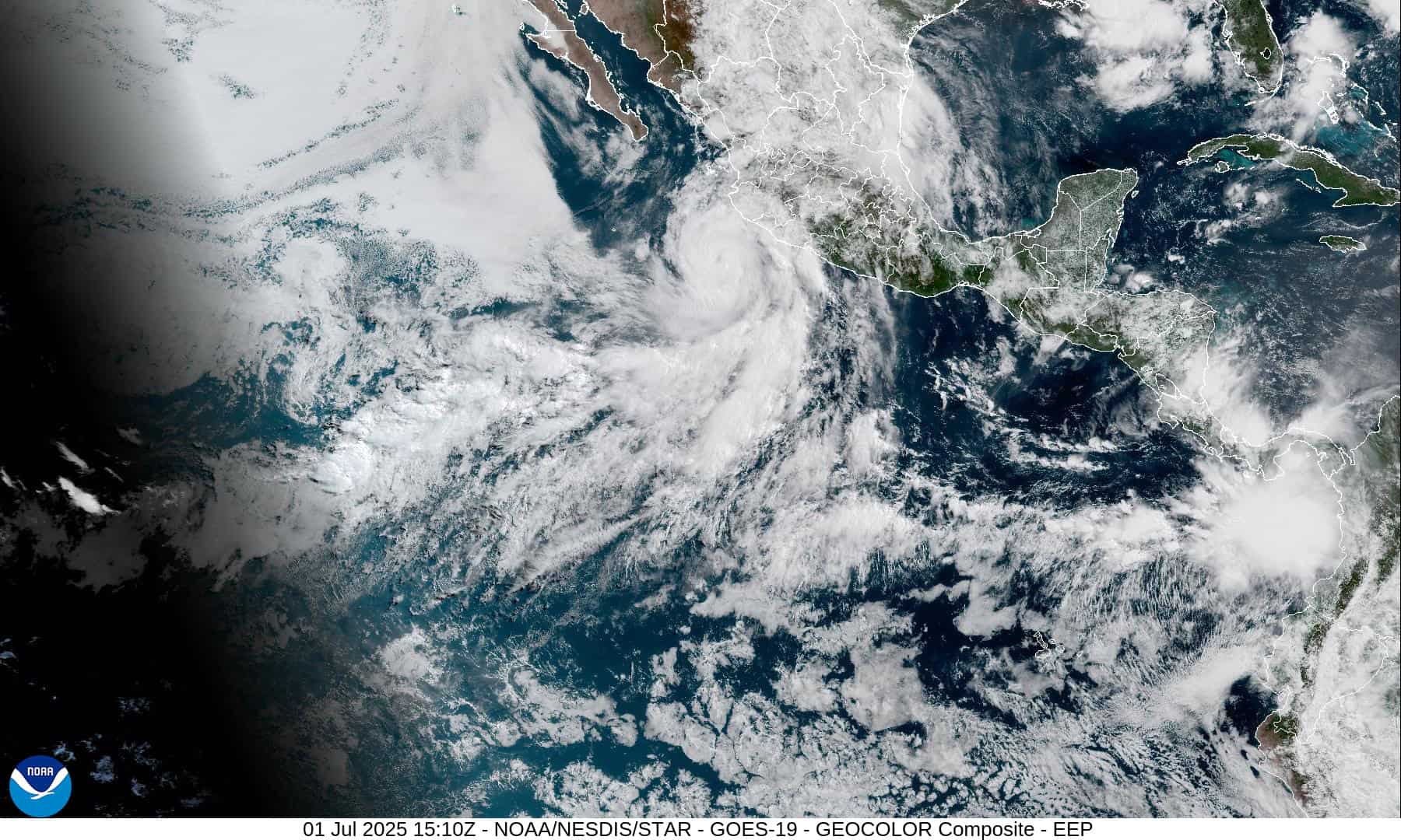
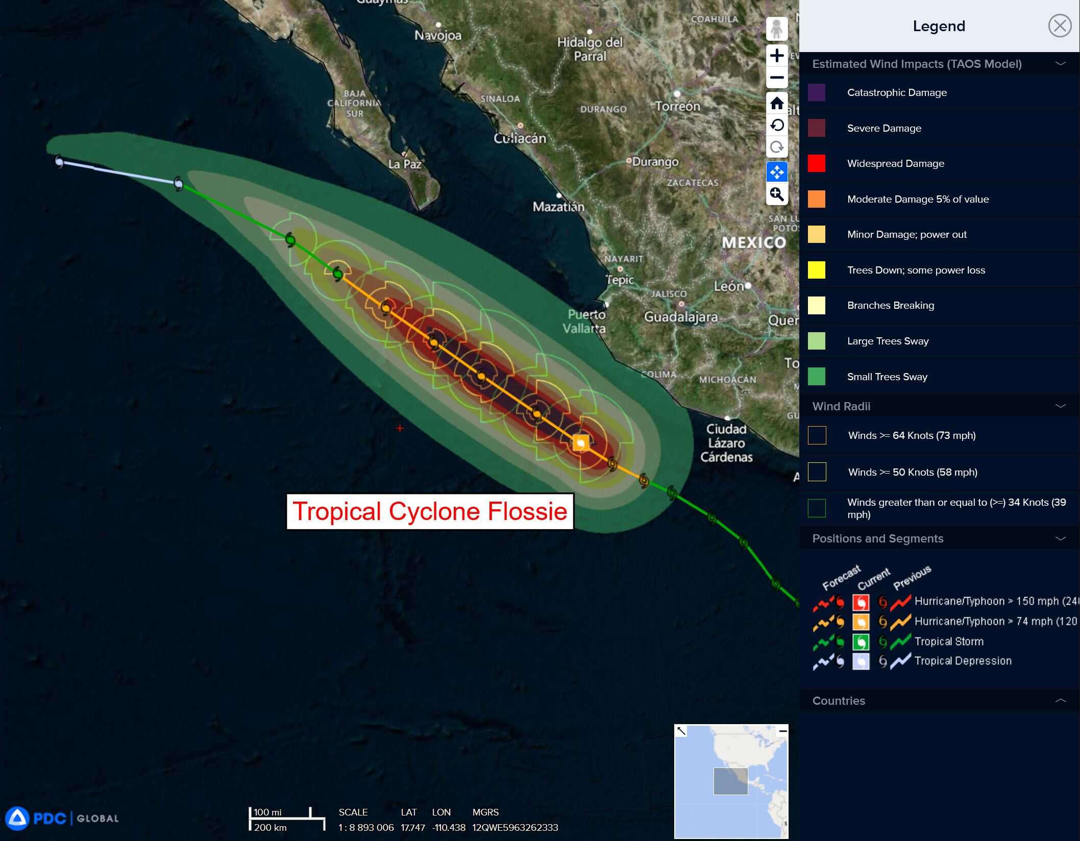
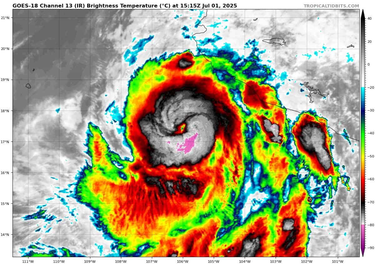
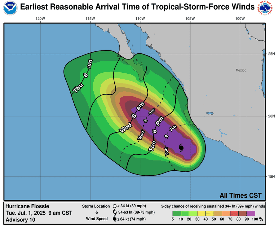
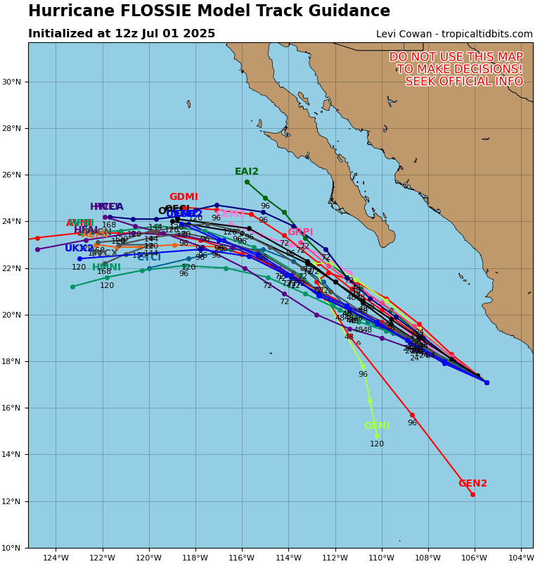
Tropical Cyclone 06E (Flossie)…is located about 230 miles west-southwest of Manzanillo, Mexico
Tropical Cyclone 04W…is located about 782 NM southeast of Yokosuka, Japan
Northeast Pacific Ocean:
Tropical Cyclone 06E (Flossie)
MAJOR HURRICANE FLOSSIE BRINGING GUSTY WINDS AND RAIN TO THE SOUTHWESTERN COAST OF MEXICO
According to the NHC advisory number 12A
Flossie is moving toward the west-northwest near 9 mph (15 km/h). A west-northwestward to northwestward motion is anticipated during the next few days. Maximum sustained winds are near 115 mph (185 km/h) with higher gusts. Flossie is a category 3 hurricane on the Saffir-Simpson Hurricane Wind Scale. Some additional strengthening is possible tonight and Wednesday morning. Later Wednesday, steady to rapid weakening is expected. Hurricane-force winds extend outward up to 25 miles (35 km) from the center and tropical-storm-force winds extend outward up to 90 miles (150 km).
SUMMARY OF WATCHES AND WARNINGS IN EFFECT:
A Tropical Storm Warning is in effect for…
* Punta San Telmo to Playa Perula
HAZARDS AFFECTING LAND
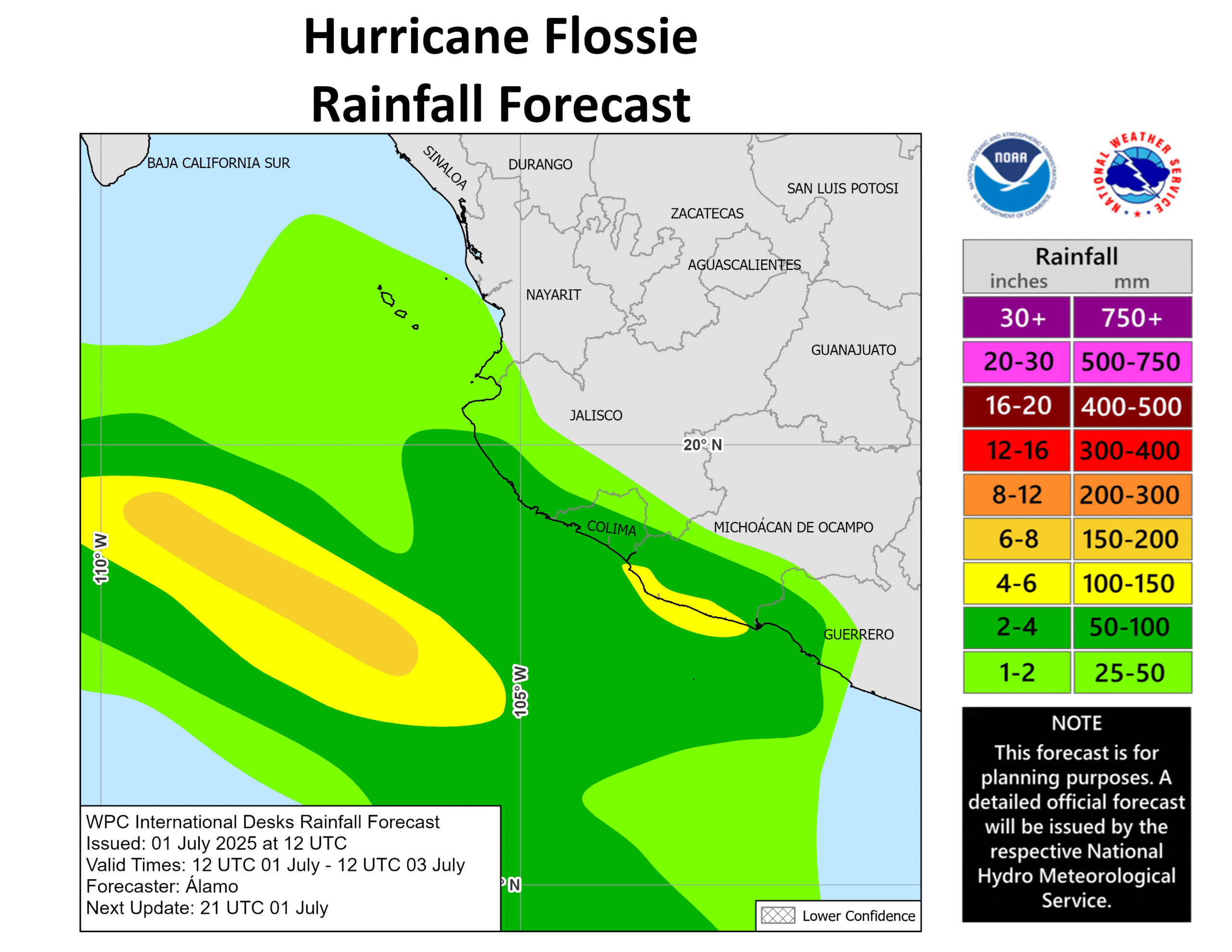
RAINFALL: Hurricane Flossie should produce additional rainfall totals of 1 to 2 inches, with isolated maximum totals of 3 inches, across coastal portions of the Mexican states of Michoacán, Colima, and Jalisco into Wednesday. This rainfall could lead to localized flash flooding.
WIND: Tropical storm conditions are expected within portions of the warning area for the next few hours.
SURF: Swells generated by Flossie will affect portions of the coast of southwestern Mexico, and the Baja California peninsula during the next few days. These swells are likely to cause life-threatening surf and rip current conditions.
South of Southwestern Mexico:
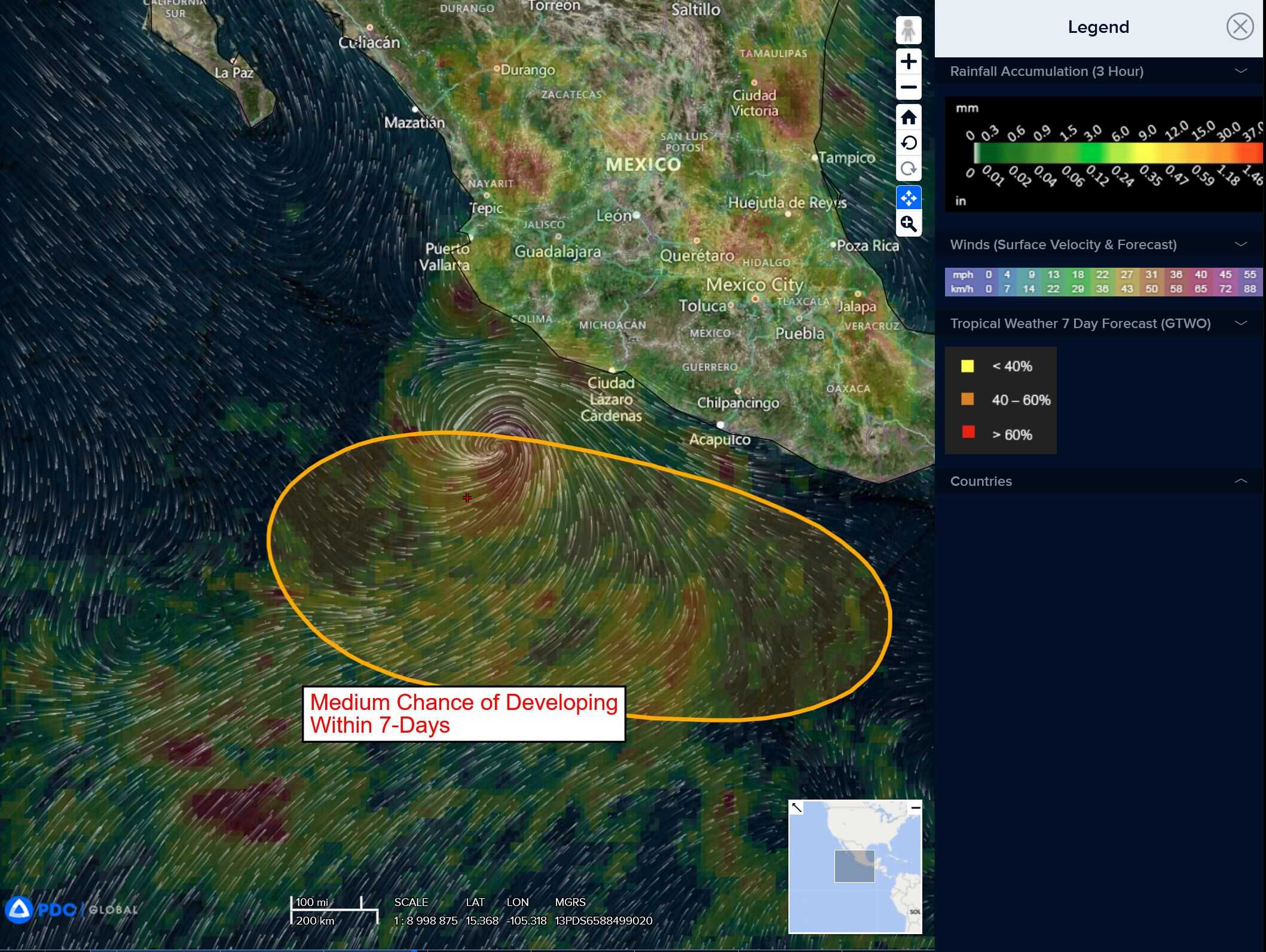
>>> An area of low pressure is forecast to develop several hundred miles offshore of southwestern Mexico in a few days. Environmental conditions appear conducive for some gradual development of this system thereafter, and a tropical depression could form over the weekend or early next week while it moves generally west-northwestward.
* Formation chance through 48 hours…low…near 0 percent
* Formation chance through 7 days…medium…50 percent
Central Pacific Ocean: There are no Tropical Cyclones
Tropical cyclone formation is not expected during the next 7-days.
Western Pacific, Indian Ocean, and adjacent Seas:
Western Pacific
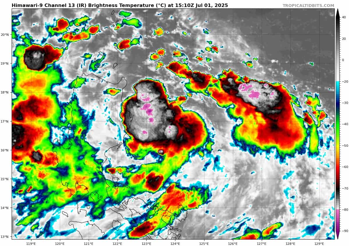
Tropical Cyclone 04W
According to the JTWC Warning number 2, sustained winds are 30 knots with gusts to 40 knots
Tropical depression 04w with deep convection slightly offset to the north of a partially exposed low-level circulation center (llcc) and a large band of convection along the eastern periphery of the system. An ascat image revealed the asymmetric nature of the wind field with the strongest winds (25-30 knots)confined to the eastern semicircle.
Environmental analysis indicates that 04W is in a marginally favorable environment characterized by strong poleward outflow aloft, low to moderate (15-20 knots) vertical wind shear, and warm sea surface temperatures. The tropical upper tropospheric trough (tutt) cell that is centered about 300 NM to the southwest of the system is currently hindering the equatorward outflow and is the main cause of the southerly vertical wind shear. The tutt cell is also introducing a tongue of dry air to the southern and southwestern portions of the circulation.
TD 04W is forecast to continue on a north-northwesterly track along the western periphery of the str through 48 hours. After 48 hours, ridging to the west will build and pull the vortex toward the northeast through the remainder of the forecast period.
Regarding intensity, 04W is forecast to steadily intensify to a peak intensity of 55 knots at 72 hours due to the overall conducive environment. The system will continue to distance itself from the tutt cell, which will allow for improvements to the equatorward outflow channel as the system gains latitude.
After 72 hours, sea surface temperatures will begin to cool, putting a halt to further intensification. And by 120 hours, sea temperatures are expected to drop, which will initiate a weakening trend. Additionally, an upper-level trough is forecast to propagate eastward and begin interacting with the system near 120 hours.
>>> An area of disturbed weather, which is being referred to as Invest 98W, is located approximately 108 NM northeast of Casiguran, Philippines
Animated enhanced infrared satellite imagery (eir) and a microwave image depicts a consolidating low level circulation center (llcc) with fragmented formative banding and building convection over the eastern periphery.
Environmental analysis for the area indicates a favorable environment for development with low level vertical wind shear (10-15 knots), moderate equatorward upper level outflow, and very warm sea surface temperatures.
Deterministic and ensembles models are in fair agreement for development, with NAVGEM being more aggressive over the next 48 hours. Models overall agree on a gradual and slow northward track over the next few days.
Maximum sustained surface winds are estimated at 15 to 20 knots.
The potential for the development of a significant tropical cyclone within the next 24 hours remains medium.