

 Your source for wildfire hazard information
Our DisasterAWARE Pro platform, as well as our Disaster Alert™ public app, provides information about wildfires happening around the world. Information is derived from a variety of scientific monitoring agencies.
Reporting Threshold
DisasterAWARE provides information about wildfires as soon as the total power of the fire reaches 18-22 gigawatts.
Coverage
√ Global (Automatically Processed)
Disaster Alert™ Mobile App
Disasters happen fast. We alert you faster.
(FREE for public use)

![]()
SmartAlert™ Early Warning
for Wildfires
DisasterAWARE Pro now includes PDC’s proprietary SmartAlert technology. You select the areas and hazards to monitor and we’ll alert you to threats within or approaching those areas automatically.
Alerting Severities:
Severity levels are designated by the authoritative reporting agency.
Natural log of aggregated fire radiative power (FRP) = 9-10 (Fire’s power= 18-22 Gigawatts)
Natural Log of Aggregated FRP = 10-11 (Fire’s power= 23-100 Gigawatts)
![]() Warning
Warning
Available Formats
Professional versions: SMS Text | Email | App Alerts
Public version: App Alerts Only
Be Aware and Prepare
Always heed instructions from local authorities and receive alerts about major hazards from PDC’s DisasterAlert app or on the DisasterAlert website.
![]()
![]()

Act now
If you are in immediate danger of a widlfire get to safety!
- Leave if told to do so.
- Listen for emergency information and alerts.
- Use N95 masks to keep particles out of the air you breathe.
Plan ahead
Live in or plan to visit a wildfire-prone area?
- Sign up for your community’s warning system.
- Know your community’s evacuation plans and find several ways to leave the area. Drive the evacuation routes and find shelter locations. Have a plan for pets and livestock.
- Gather emergency supplies, including N95 respirator masks that filter out particles in the air you breathe. Keep in mind each person’s specific needs, including an updated asthma action plan and medication. Don’t forget the needs of pets.
- Designate a room that can be closed off from outside air. Close all doors and windows. Set up a portable air cleaner to keep indoor pollution levels low when smoky conditions exist.
- Keep important documents in a fireproof, safe place. Create password-protected digital copies.
- Use fire-resistant materials to build, renovate, or make repairs.
- Find an outdoor water source with a hose that can reach any area of your property.
- Create a fire-resistant zone that is free of leaves, debris, or flammable materials for at least 30 feet from your home.
- Pay attention to air quality alerts.
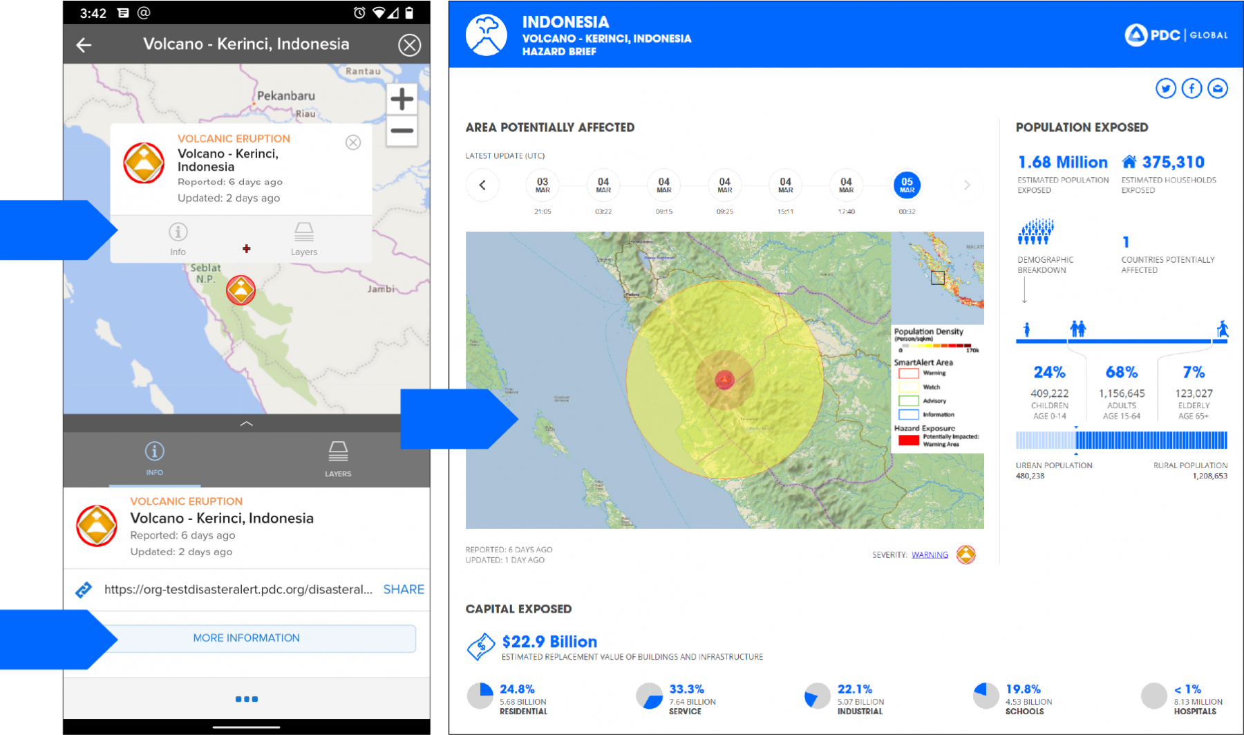
Hazard Brief
Real-Time Impact and Needs Assessment
Through DisasterAWARE Pro and Disaster Alert you get access to PDC’s unique exposure modeling capabilities—providing accurate assessments of exposure and need for hazards in any part of the world.
How to access Hazard Brief (available for all hazards)
Specialized Wildfire Products
for Disaster Management Practitioners
DisasterAWARE provides specialized situational analysis reports for use by disaster management practitioners. Some of these are generated automatically with every advisory, while others are custom created by PDC as needed to support hazard response.


Helpful Features and Layers
Apps powered by DisasterAWARE provide layers of information to help assess the impacts of volcanoes. These include but are not limited to:
• Rainfall accumulation (3 hour, 1 day)
• Wildfire perimeters (U.S.)
• Potential large/intense wildfires
• Lightning strike density
• Potential wildfire locations (hotspots)
• Wildfires (U.S.)
• Wildfire activity areas (24 hours)
• Global weather observations (METAR)*
• U.S. watches, warnings and advisories*
• Rainfall accumulation (3 day, 7 day)*
* = For disaster management practitioners only
