

")
Tropical Cyclone 19S (Fabien) / Tropical Cyclone 02W (Mawar)
Sunday, May 21, 2023
Current Snapshot
For all the latest updates visit: DisasterAWARE
pdceastpac

pdcclouds

pdcfabien

19S_tracks_latest

pdcmawar
02W_tracks_latest
By PDC’s Senior Weather
Specialist Glenn James

Current Tropical Cyclones:
Tropical Cyclone 19S (Fabien)…is located approximately 321 NM southwest of Diego Garcia – Final Warning
Tropical Cyclone 02W (Mawar)…is located approximately 108 NM north-northeast of Satawal
Northeast Pacific Ocean:
There are no tropical cyclones…nor any areas of disturbed weather under investigation by the National Hurricane Center (NHC)
Tropical cyclone formation is not expected during the next 7 days.
South Indian Ocean
Tropical Cyclone 19S (Fabien) – Final Warning
According to the JTWC Warning number 27, sustained winds were 25 knots, with gusts to 35 knots.
Animated multi-spectral satellite imagery depicts flaring deep convection, partially obscuring the low level circulation center and surrounding tightly wrapped low level cloud lines. A microwave image indicates an elongated circulation with deteriorating convection and rampant dry air entrainment.
TC 19S (Fabien) will continue tracking generally poleward over the next 48 hours. During this time, the environment surrounding the system will provide enough energy to maintain its current intensity, due primarily to relatively low
vertical wind shear and marginally favorable outflow.
The system will become more asymmetric as the upper-level circulation tilts and decouples from the low level (llcc )circulation center by 24 hours. The exposed and quickly deteriorating llcc will then turn sharply westward and dissipate by 72 hours.
Western Pacific Ocean
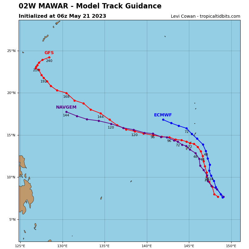
Tropical Cyclone 02W (Mawar)
According to the JTWC Warning number 9, sustained winds were 85 knots, with gusts to 105 knots.
Animated enhanced infrared satellite imagery depicts an expanding central dense overcast feature that is fully obscuring the low level circulation center beneath. A recent microwave image reveals improved core convection with a partially exposed southern semicircle allowing the tightly wrapping low level cloud lines below to be seen.
TY 02W (Mawar) has continued to rapidly intensify over the past six hours. As the system continues to pick up speed under the steering influence of the ridge to the east, 02W is forecast to maintain a generally north-northwestward track.
The environment surrounding 02W is forecast to remain favorable, characterized by warm sea surface temperatures and robust outflow aloft, both poleward and westward, overwhelming the negative effects of limited dry air entrainment and moderate mid-upper level vertical wind shear.
Having recently achieved typhoon strength, the system will continue to develop over the next several days hours, fueled by the aforementioned robust outflow aloft and warm sea surface temperatures.
Near 72 hours, the ridge to the east reorients and builds further northeast of the system, forcing it to steady up on a generally west-northwestward course after passing north of Guam.
By 120 hours, now over the warm waters and deep ocean heat content of the Philippine Sea, 02W will reach a peak intensity of 115 knots as it continues west-northwestward.
