

")
Tropical Cyclone 18S / Invest 90W
Sunday, April 9, 2023
Current Snapshot
For all the latest updates visit: DisasterAWARE
pdc18s

18S_091800sair
By PDC’s Senior Weather
Specialist Glenn James

Current Tropical Cyclones:
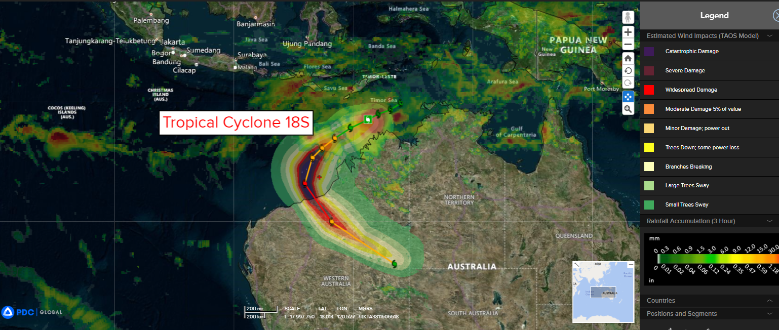
Tropical Cyclone 18S…is located approximately 267 NM north-northeast of Broome, Australia
South Indian Ocean
Tropical Cyclone 18S
According to JTWC Warning number 6, sustained winds were 50 knots, with gusts to 65 knots.
Tropical cyclone (TC) 18S has struggled to consolidate over the past six hours due to a renewed burst of easterly vertical wind shear evident in animated enhanced infrared satellite imagery.
TC 18S is expected to track west-southwestward to southwestward through 48 hours along the northwest periphery of the ridge. After 48 hours, the system will recurve southward as a mid-latitude shortwave trough digs into western Australia weakening the ridge. The system will accelerate southeastward after 96 hours when another shortwave trough propagates over western Australia.
Environmental conditions should improve within the next 12 hours allowing TC 18S to rapidly intensify aided by enhanced poleward outflow, warm sea surface temperature values and high ocean heat content, especially off the coast of northwest Australia. The peak intensity of 130 knots should occur just prior to landfall.
Northwest Pacific Ocean
>>> There’s an area of disturbed weather being referred to as Invest 90W…which is located approximately 656 NM east-southeast of Legazpi, Philippines.
Animated multi-spectral satellite imagery depicts a broad low-level circulation (llc) with the strongest convection to the north of the llc.
Environmental analysis reveals favorable conditions for development with moderate poleward outflow aloft, low to moderate vertical wind shear (15-20 knots), and warm sea surface temperatures.
Global models are in agreement that 90W will gradually develop as it tracks west-northwestward toward the Philippines.
Maximum sustained surface winds are estimated at 20 to 24 knots.
The potential for the development of a significant tropical cyclone within the next 24 hours is upgraded to high.
