

")
Tropical Cyclone 18E (Otis) /Tropical Cyclone 01P (Lola) / Tropical Cyclone 06B (Hammond) / Tropical Cyclone 05A (Tej)
Monday, October 23, 2023
Current Snapshot
For all the latest updates visit: DisasterAWARE

1800×10803

1800×10804
pdcepac

pdclola

jtwclola

01P_tracks_latest
pdc06b

tsat06b

06B_tracks_latest

pdctej

tsattej

05A_tracks_latest
By PDC’s Senior Weather
Specialist Glenn James

The Pacific Disaster Center’s (PDC Global) Monday, October 23, 2023, Tropical Cyclone Activity Report…for the Pacific Ocean, the Indian Ocean, and adjacent Seas
Current Tropical Cyclones:
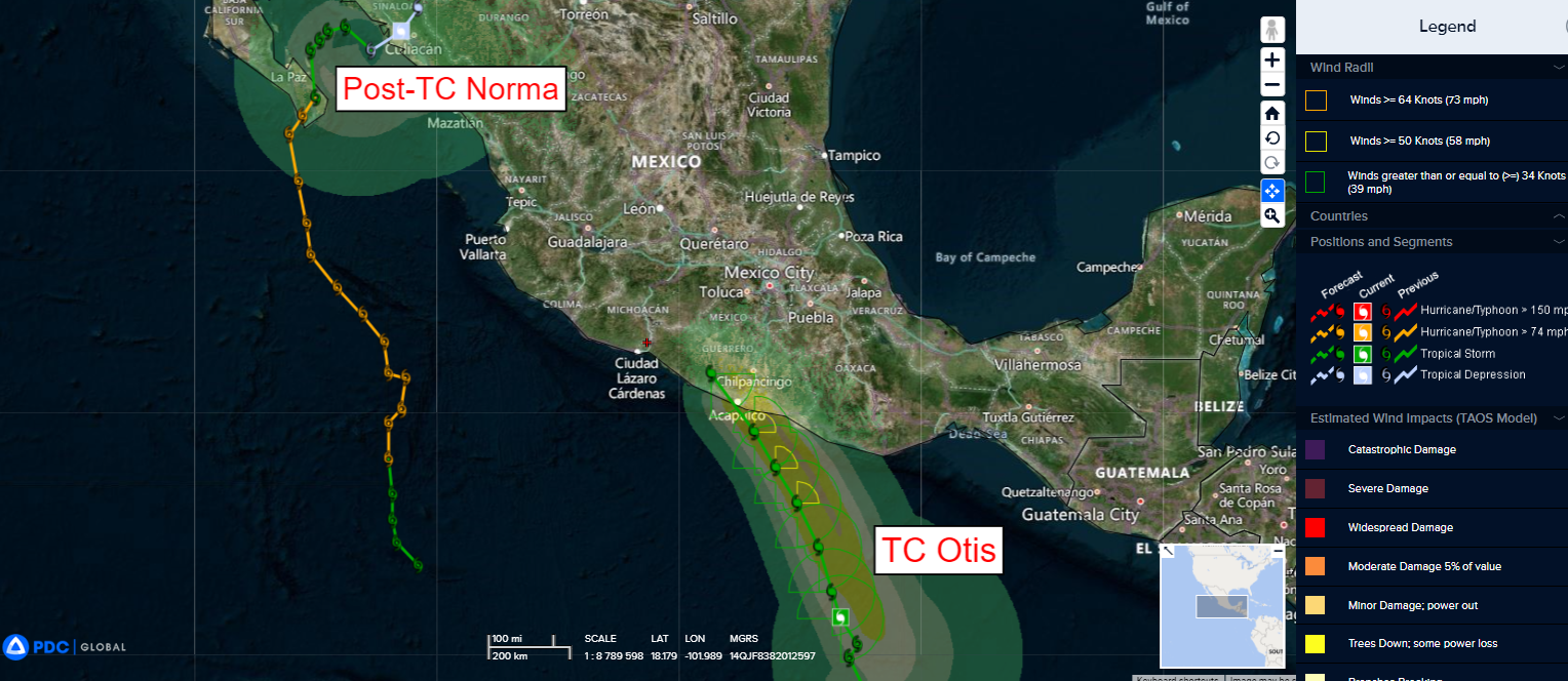
Tropical Cyclone 18E (Otis) …is located approximately 290 miles south-southeast of Acapulco, Mexico
Tropical Cyclone 01P (Lola) …is located approximately 229 NM north-northeast of Port Vila, Vanuatu
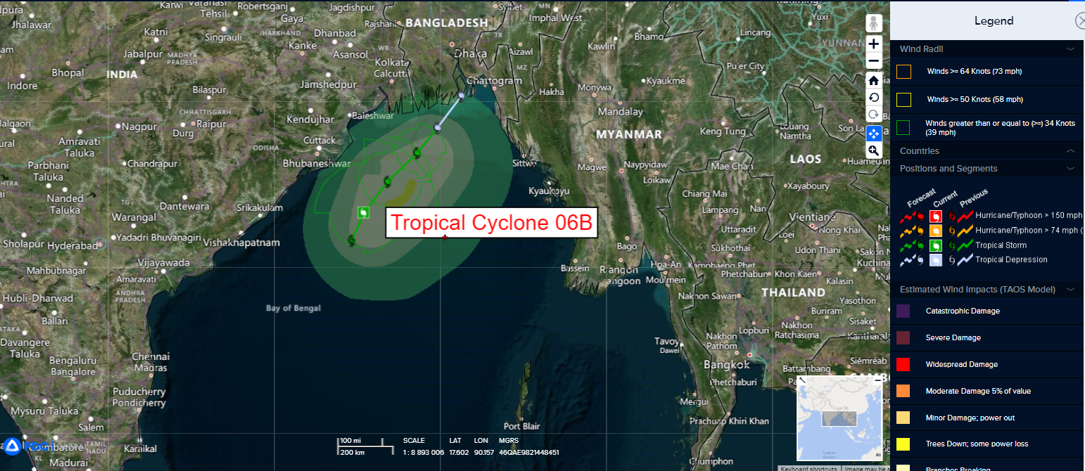
Tropical Cyclone 06B (Hammond)…is located approximately 205 NM south of Kolkata, India
Tropical Cyclone 05A (Tej) …is located approximately 137 NM southwest of Salalah, Oman
Northeast Pacific Ocean:
Tropical Cyclone 18E (Otis)
OTIS MOVING NORTH-NORTHWESTWARD…FORECAST TO BE NEAR HURRICANE STRENGTH AT LANDFALL
According to the NHC advisory number 6A…sustained winds were 45 knots, with gusts to 55 knots
Otis is moving toward the north-northwest near 7 mph (11 km/h), and this general motion is expected during the next few days. On the forecast track, Otis is expected to reach the coast of southern Mexico on Wednesday.
Maximum sustained winds remain near 50 mph (85 km/h) with higher gusts. Gradual strengthening is forecast, and Otis is expected to be near hurricane strength before it reaches southern Mexico.
Tropical-storm-force winds extend outward up to 70 miles (110 km) from the center.
Central North Pacific:
There are no tropical cyclones, nor any areas of disturbed weather under investigation by the CPHC at the time of this writing.
Western Pacific, Indian Ocean and adjacent Seas:
Southwestern Pacific
Tropical Cyclone 01P (Lola)
According to the JTWC warning number 9…sustained winds were 115 knots, with gusts to 140 knots
Animated multi-spectral satellite imagery shows a medium-sized system with rain bands wrapping in tighter from all quadrants into a symmetrical cold dense overcast with deepening and overshooting cloud tops and has maintained a ragged and elongated 15 NM eye.
TC Lola will track more southwestward as the steering ridge builds. After 72 hours, the ridge is weakened by a shortwave trough approaching from the southwest, allowing the system to track more southward then south-southeastward as it rounds the ridge axis.
The favorable environment will fuel a steady intensification to a peak of 100 knots by 12 hours. Afterward, interaction with the islands of Vanuatu, increasing vertical wind shear, then cooling sea surface temperatures will gradually then rapidly erode the system to dissipation by 96 hours.
North Indian Ocean
Tropical Cyclone 06B (Hammond)
According to the JTWC warning number 3…the system had sustained winds of 50 knots, with gusts to 65 knot
Animated multi-spectral satellite imagery depicts tropical cyclone 06B persisting in a favorable environment over the past six hours. the low level circulation center (llcc) remains completely obscured by centralized and intermittently flaring convection that appears to be cyclonically circumnavigating the llcc. Ongoing deep convection continues throughout a 275 NM long band northeast of the llcc.
TC 06B is forecast to track northeastward over the next 48 hours. Through 12 hours, the system is likely to take advantage of a favorable environment and gradually intensify. After 12 hours, vertical wind shear increases (45 knots by 48 hours).
Additionally, a shortwave trough is forecast to dig south from the north over the northern Bay of Bengal (between 6 to 18 hours) and is anticipated to rapidly weaken TC 06B with the introduction of deep-layer westerly flow. Complete dissipation is forecast to occur prior to 48 hours.
Arabian Sea
Tropical Cyclone 05A (Tej)
According to the JTWC warning number 14…sustained winds were 70 knots, with gusts to 85 knots
Animated multi-spectral satellite imagery shows the system has lost its eye yielding to a ragged remnant eye feature as the cold dense overcast warmed and feeder bands loosened. A dry slot along the southwest flank is also evident.
Under the steering ridge, TC Tej will continue to track northwestward toward eastern Yemen, making landfall before
12 Hours.
The unfavorable environment will gradually weaken the system down to 75 knots at landfall. Afterward, increasing cool northerly dry air entrainment from the Arabian Peninsula in addition to land interaction with the dry Yemeni Desert will rapidly erode the system to dissipation by 36 hours, very likely sooner.
