

")
Tropical Cyclone 14W (Koinu) / Invest 98E
Monday, October 2, 2023
Current Snapshot
For all the latest updates visit: DisasterAWARE

1800×1080

1800×10801

pdc2

pdcepac2
tsat98e

98E_tracks_latest

pdcK

jtwcsatk

himawari9_ir_14W_202310021450_lat19.9-lon126.3

14W_tracks_latest
By PDC’s Senior Weather
Specialist Glenn James

The Pacific Disaster Center’s (PDC Global) Monday, October 2, 2023, Tropical Cyclone Activity Report…for the Pacific Ocean, the Indian Ocean, and adjacent Seas
Current Tropical Cyclones:
Tropical Cyclone 14W (Koinu)…is located approximately 340 NM southeast Taipei, Taiwan
Northeast Pacific Ocean:
>>>South of Southwestern Mexico…
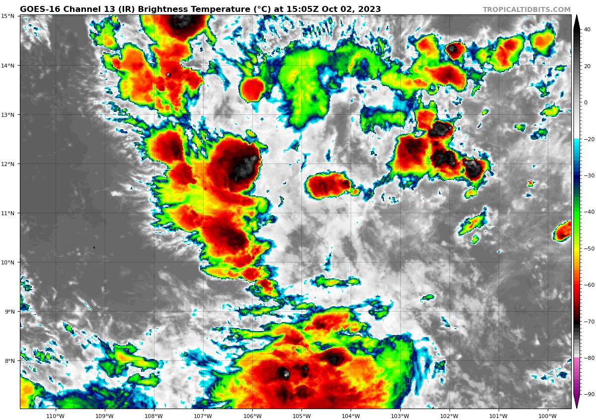
Invest 98E
Showers and thunderstorms continue to show signs of organization in association with a broad area of low pressure located several hundred miles south of the coast of southwestern Mexico.
Environmental conditions are expected to remain favorable for development, and a tropical depression is likely to form during the next day or so. The system is forecast to move generally northwestward through the end of the week.
* Formation chance through 48 hours…high…90 percent
* Formation chance through 7 days…high…100 percent
>>> South of Central America…
An area of low pressure is expected to form a few hundred miles south of the coast of Central America during the next few days.
Afterward, environmental conditions are expected to be conducive for gradual development of the disturbance, and a tropical depression could form late this week or over the weekend while the system moves slowly westward or west-northwestward.
* Formation chance through 48 hours…low…near 0 percent
* Formation chance through 7 days…high…70 percent
Central North Pacific:
There are no tropical cyclones, nor any areas of disturbed weather under investigation by the CPHC at the time of this writing.
Western Pacific, Indian Ocean and adjacent Seas:
Western Pacific…
Tropical Cyclone 14W Koinu
According to the JTWC Warning number 15…
Sustained winds were 105 knots…with gusts to near 130 knots
Animated enhanced infrared satellite imagery depicts a robust typhoon strength circulation with an improved 15 NM eye. Vigorous equatorward outflow is creating an symmetric appearance to the convective banding around the system. A microwave image reveals tightly wrapping convective banding features in all quadrants though the bulk of the peripheral convection is in the southwestern quadrant, down shear of the system.
typhoon 14W (Koinu) is likely at or near its peak intensity and the system is forecast to continue on a generally northwestward track under the steering influence of the deep-layer subtropical ridge (str) centered to the east. As
evidenced by the asymmetric appearance in satellite imagery, 14W is experiencing increased mid-upper level vertical wind shear and dry air entrainment.
Over the next 12 hours, these negative factors are generally negated by favorable outflow aloft and warm sea surface temperatures which will likely maintain or slightly increase the systems intensity. By 24 hours however, the party will be over as favorable equatorward outflow is lost. This fact, coupled with increasing vertical wind shear and dry air entrainment, the system will begin to gradually weaken.
As the str to the east builds westward, 14W will be forced towards the southern tip of Taiwan, as it continues to slowly weaken. After making landfall past 48 hours, the mountainous eastern coast of Taiwan will sharply weaken 14W to 75 knots by 72 hours.
In the extended track, 14W is forecast to slowly transit the Taiwan Strait as
additional cool dry air steams into the system from the north. This will result in continued weakening through 120 hours, as the system approaches mainland China.
