

")
Tropical Cyclone 15E (Lidia) / Tropical Cyclone 14W (Koinu)
Wednesday, October 4, 2023
Current Snapshot
For all the latest updates visit: DisasterAWARE
epac1
epac2

pdclidia

tsatlidia

144354_earliest_reasonable_toa_34lidia

15E_tracks_latestlidia

pdc2

pdc7

pdc22

pdc77

pdckoinu

jtwc

tsat14w

14W_tracks_latest
By PDC’s Senior Weather
Specialist Glenn James

The Pacific Disaster Center’s (PDC Global) Wednesday, October 4, 2023, Tropical Cyclone Activity Report…for the Pacific Ocean, the Indian Ocean, and adjacent Seas
Current Tropical Cyclones:
Tropical Cyclone 15E (Lidia)…is located about 505 miles south of Cabo San Lucas, Mexico
Tropical Cyclone 14W (Koinu)…is located approximately 190 NM south-southwest of Taipei, Taiwan
Northeast Pacific Ocean:
Tropical Cyclone 15E (Lidia)
LIDIA MAINTAINING ITS STRENGTH
According to the NHC Advisory number 8…
Lidia is moving toward the northwest near 7 mph (11 km/h). This general northwestward to north-northwestward motion with a reduction in forward speed is forecast during the next day or so. Beginning later Thursday, a much slower westward motion is expected.
Maximum sustained winds are near 50 mph (85 km/h) with higher gusts. Some slow strengthening is forecast over the next few days.
Tropical-storm-force winds extend outward up to 70 miles (110 km) from the center.
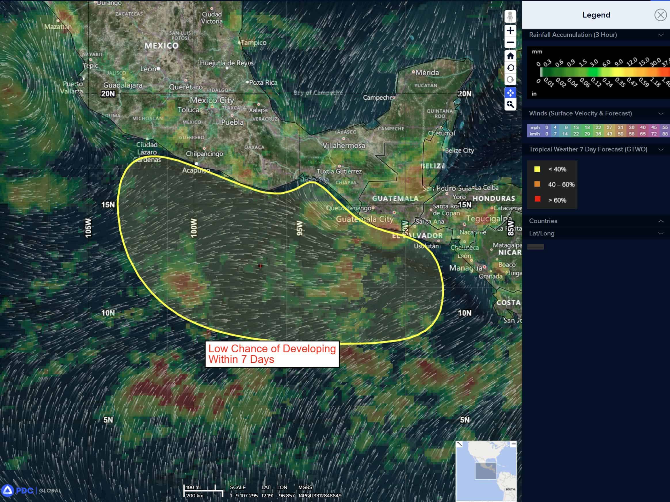
>>> South of Central America…
A large, elongated area of showers and thunderstorms located well south of the coast of Guatemala is associated with a trough of low pressure.
Environmental conditions are expected to be conducive for gradual development during the next several days, and a tropical depression is likely to form this weekend or early next week while the disturbance moves slowly west-northwestward.
* Formation chance through 48 hours…low…20 percent
* Formation chance through 7 days…high…80 percent
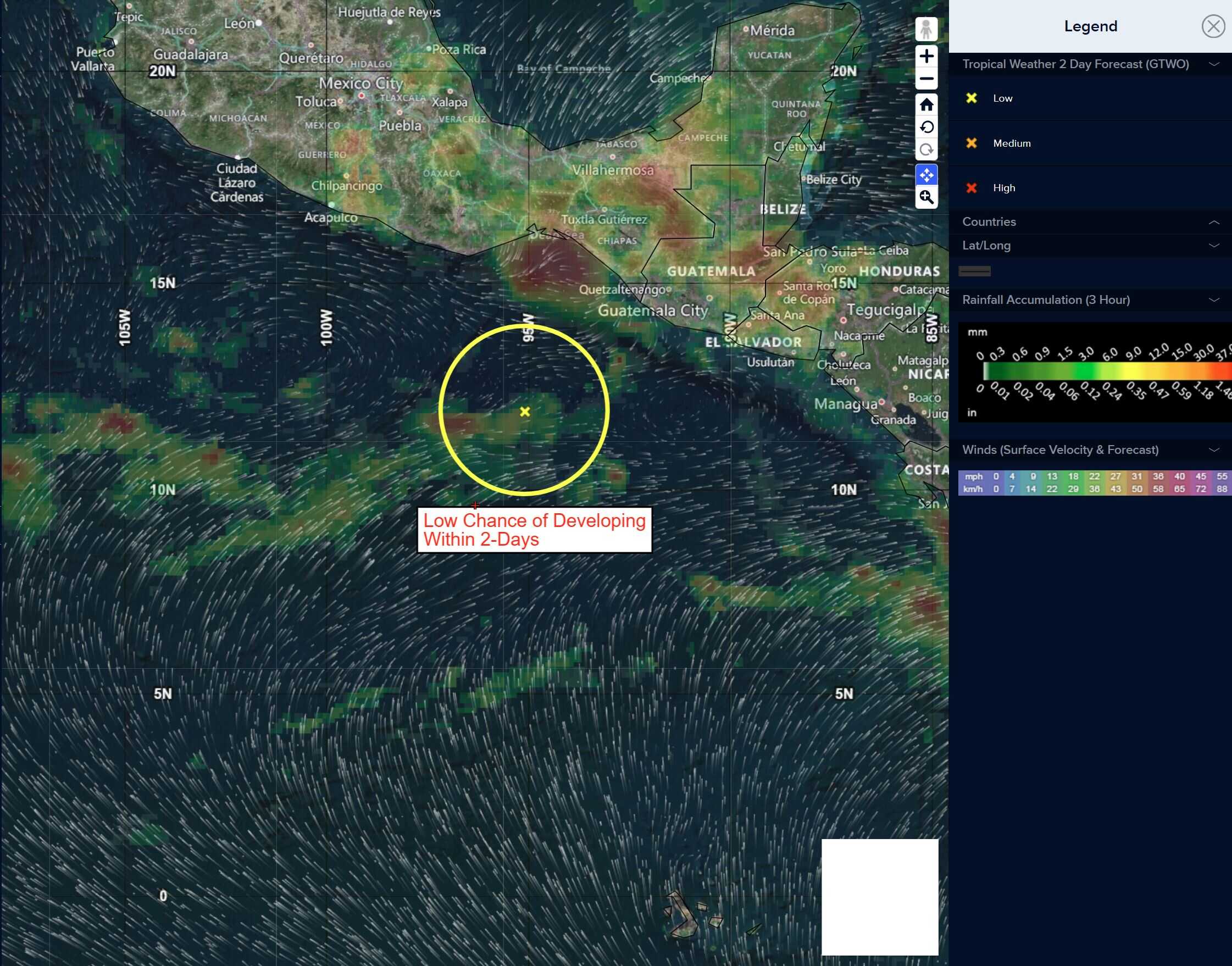
>>> Western East Pacific…
An area of low pressure located about 1200 miles southwest of the southern tip of the Baja California peninsula is producing disorganized showers and thunderstorms. Development of this system, if any, should be slow to occur while it moves little during the next couple of days. By this weekend, environmental conditions are forecast to become less conducive for further development.
* Formation chance through 48 hours…low…10 percent
* Formation chance through 7 days…low…10 percent
Central North Pacific:
There are no tropical cyclones, nor any areas of disturbed weather under investigation by the CPHC at the time of this writing.
Western Pacific, Indian Ocean and adjacent Seas:
Western Pacific…
Tropical Cyclone 14W Koinu
According to the JTWC Warning number 23…
Sustained winds were 110 knots…with gusts to near 135 knots
Animated enhanced infrared satellite imagery depicts the typhoon approaching Taiwan and beginning to interact with the mountainous terrain of the central mountain range. A distinguishable line of very cool air outlines the crest of the significant topographical feature, causing a significant disruption in low to mid-level flow around the system. The ragged eye of the system has decreased to 12 NM in diameter.
Vertical wind shear has increased to (20-25 knots), with the 24 hour vertical wind shear tendency increasing as well (10 knots). Sea surface temperatures west of the system and along the forecast track fall slightly, yet remain conducive for intensification to occur.
Typhoon 14W is forecast to track westward through 72 hours, when it will then turn to a more west-southwestward track. With the onset of frictional forcing at time of analysis, the intensity of the system is anticipated to decrease through 24 hours as 14W tracks westward past Taiwan.
Additionally, vertical wind shear is anticipated to be moderate through 24 hours and lower thereafter. Thereafter, the system is anticipated to track into a sizable dry air mass (around 20 percent relative humidity) and the effects of dry air entrainment will gradually weaken the intensity through 120 hours.
