

")
Tropical Cyclone 13E (Kenneth) / Invest 96W
Wednesday, September 20, 2023
Current Snapshot
For all the latest updates visit: DisasterAWARE
3

4

kenneth

tsatkenneth

152730_earliest_reasonable_toa_34ken

13E_tracks_latestken

epac7

96w

himawari9_ir_96W_202309201540_lat14.9-lon157.0
96W_tracks_latest
By PDC’s Senior Weather
Specialist Glenn James

The Pacific Disaster Center’s (PDC Global) Wednesday, September 20, 2023, Tropical Cyclone Activity Report…for the Pacific Ocean, the Indian Ocean, and adjacent Seas
Current Tropical Cyclones:
Tropical Cyclone 13E (Kenneth)…is located about 1075 miles west-southwest of the southern tip of Baja California
Northeast Pacific Ocean:
Tropical Cyclone 13E (Kenneth)
KENNETH TURNS NORTHWESTWARD…FORECAST TO DEGENERATE INTO A REMNANT LOW IN A COUPLE OF DAYS
According to the NHC advisory number 7
Kenneth ismoving toward the northwest near 12 mph (19 km/h). A turn toward the north-northwest and north at a slightly slower forward speed is expected Thursday and Thursday night. A northward motion is forecast to continue through Saturday.
Maximum sustained winds are near 50 mph (85 km/h) with higher gusts.
Weakening is forecast to begin on Thursday. Kenneth could degenerate into a remnant low by late Friday.
>>> Western East Pacific…
Invest 96E
An area of low pressure located about 1200 miles east-southeast of the Hawaiian Islands continues to produce disorganized shower activity.
Some gradual development of this system is possible through the end of the week before environmental conditions become less favorable. The low is expected to move westward at 5 to 10 mph, reaching the Central Pacific basin early Thursday.
* Formation chance through 48 hours…low…20 percent
* Formation chance through 7 days…low…30 percent
>>> Central East Pacific…
A trough of low pressure located several hundred miles south of the southwestern coast of Mexico is producing disorganized showers and thunderstorms.
Gradual development of this system is possible over the next several days, and a tropical depression could form by early next week while it moves westward across the central and western part of the eastern Pacific basin.
* Formation chance through 48 hours…low…near 0 percent
* Formation chance through 7 days…medium…40 percent
Central North Pacific:
>>> Western East Pacific…
Invest 96E
An area of low pressure located about 1200 miles east-southeast of the Hawaiian Islands continues to produce disorganized shower activity. Some gradual development of this system is possible through the end of the week before environmental conditions become less favorable. The low is expected to move westward at 5 to 10 mph, reaching the Central Pacific basin early Thursday.
* Formation chance through 48 hours…low…20 percent
* Formation chance through 7 days…low…30 percent
Elsewhere, no tropical cyclones are expected during the next 7 days.
Western Pacific, Indian Ocean and adjacent Seas:
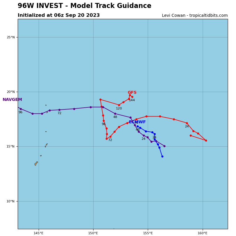
>>> There’s an area of disturbed weather being referred to as Invest 96W…which is located approximately 778 NM east of Guam
Animated multi-spectral satellite imagery and a microwave pass depict slowly consolidating deep convection with formative banding.
Environmental analysis indicates that 96W is in a favorable environment for development with robust poleward outflow, enhanced by an upper-low to the north, low (10-15 knot) vertical wind shear, and warm sea surface temperatures.
Conversely, global models do not show significant development of the system. GFS has notably weakened the forecast intensification of 96W over the last few model runs. Global models indicate a slow west-northwestward track over the next 48 hours.
Maximum sustained surface winds are estimated at 15 to 20 knots.
The potential for the development of a significant tropical cyclone within the next 24 hours is upgraded to medium.
