

")
Tropical Cyclone 14W (Koinu) / Invest 90B / Invest 99A
Friday, September 29, 2023
Current Snapshot
For all the latest updates visit: DisasterAWARE

1800×108077

1800×1080777

pdc7epac

pdc14W
jtwc14w
14W_tracks_latest

pdc90B

tsat90B

90B_tracks_latest

pdc99A

meteosat9_ir_99A_202309291551_lat15.9-lon72.5

99A_tracks_latest
By PDC’s Senior Weather
Specialist Glenn James

The Pacific Disaster Center’s (PDC Global) Friday, September 29, 2023, Tropical Cyclone Activity Report…for the Pacific Ocean, the Indian Ocean, and adjacent Seas
Current Tropical Cyclones:
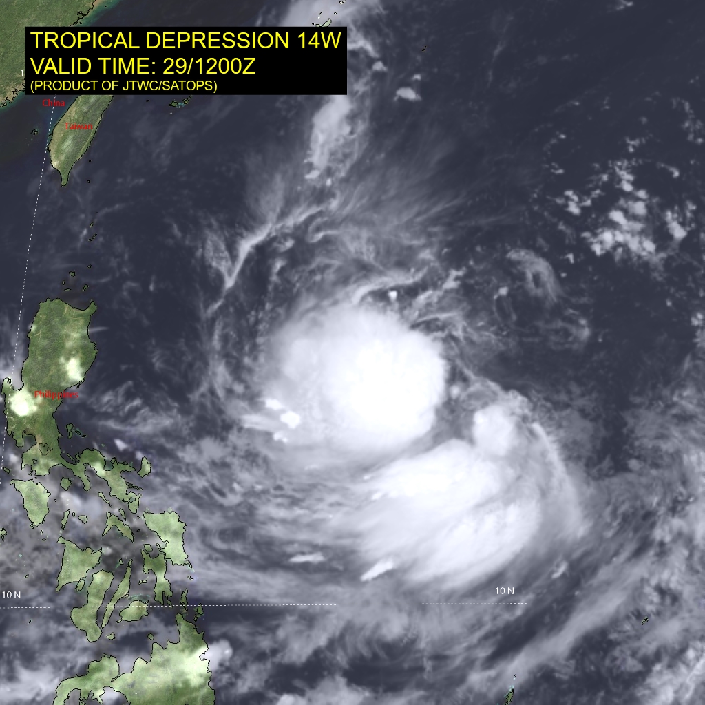
Tropical Cyclone 14W (Koinu)…is located approximately 503 NM northwest of Yap
Northeast Pacific Ocean:
>>>South of Southwestern Mexico…
An area of low pressure is expected to form well south of the coast of southwestern Mexico early next week.
Environmental conditions are expected to support at least gradual development of the disturbance and a tropical depression could form during the middle to later part of the week while the system moves generally northwestward.
* Formation chance through 48 hours…low…near 0 percent
* Formation chance through 7 days…medium…40 percent
Central North Pacific:
There are no tropical cyclones, nor any areas of disturbed weather under investigation by the CPHC at the time of this writing.
Western Pacific, Indian Ocean and adjacent Seas:
Western Pacific…
Tropical Cyclone 14W Koinu
According to the JTWC Warning number 3…
Sustained winds were 33 knots…with gusts to near 40 knots
Animated satellite imagery depicts tropical depression 14W gradually developing and tracking westward at approximately 6 knots over the past six hours. Deep, persistent convection is observed along the southwestern periphery of a partially exposed low level circulation center.
Thin, wispy cirrus are observed flowing weakly poleward and equatorward aloft. A microwave image shows shallow cloud banding wrapping into the llcc with fairly broad outreach, up to 370 NM out from the center of circulation.
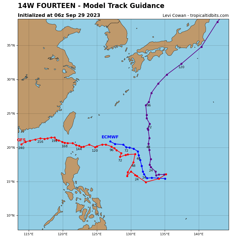
Over the next 72 to 96 hours, tropical depression 14W is forecast to track on a northwestward trajectory and gradually intensify. Favorable sea surface temperatures and ocean heat content are offset by dry air (below 50 percent relative humidity) and significant shear in the upper layers.
Between 72 and 96 hours, shear is forecast to reduce and the environment becomes more moist, allowing for quicker (possibly rapid) intensification to occur. The forecast confidence of both track and intensity is medium through 72 hours.
Indian Ocean and adjacent Sea…
>>> There’s an area of disturbed weather being referred to as Invest 90B…which is located approximately 170 NM south-southwest of Chittagong, Bangladesh
Animated multi-spectral satellite imagery and a microwave image depict a very broad area of low level turning with scattered, disorganized convection over the Bay of Bengal.
Environmental analysis indicates that 90B is in a favorable environment for development with good outflow aloft, low (5-10 knot) vertical wind shear, and warm sea surface temperatures.
Global numerical models agree that 90B will track slowly northwestward as it continues to develop over the next 48 hours.
Maximum sustained surface winds are estimated at 15 to 20 knots.
The potential for the development of a significant tropical cyclone within the next 24 hours is low.
>>> There’s an area of disturbed weather being referred to as Invest 99A…which is located approximately 186 NM south-south of Mumbai, India
Animated multi-spectral satellite imagery and a microwave image depict a mostly obscured low level circulation center with deep convective bursts.
Environmental analysis indicates that 99A is in a favorable environment for development with good outflow aloft, low to moderate (15-20 knot) vertical wind shear, and warm sea surface temperatures.
Global numerical models agree that 99A will be quasi-stationary as it continues to develop over the next 48 hours.
Maximum sustained surface winds are estimated at 20 to 25 knots.
The potential for the development of a significant tropical cyclone within the next 24 hours is medium.
