

")
Tropical Cyclone 05W (Doksuri)
Saturday, July 22, 2023
Current Snapshot
For all the latest updates visit: DisasterAWARE

05w

05W_221200sair
05W_tracks_latest
By PDC’s Senior Weather
Specialist Glenn James

The Pacific Disaster Center’s (PDC Global) Saturday, July 22, 2023, Tropical Cyclone Activity Report…for the Pacific Ocean, the Indian Ocean, and adjacent Seas
Current Tropical Cyclones:
Tropical Cyclone 05W (Doksuri)…is located approximately 493 NM northwest of Kayangel
Northeast Pacific Ocean:
There are no tropical cyclones
Central Pacific Ocean:
There are no tropical cyclones
Western Pacific, Indian Ocean and adjacent Seas:
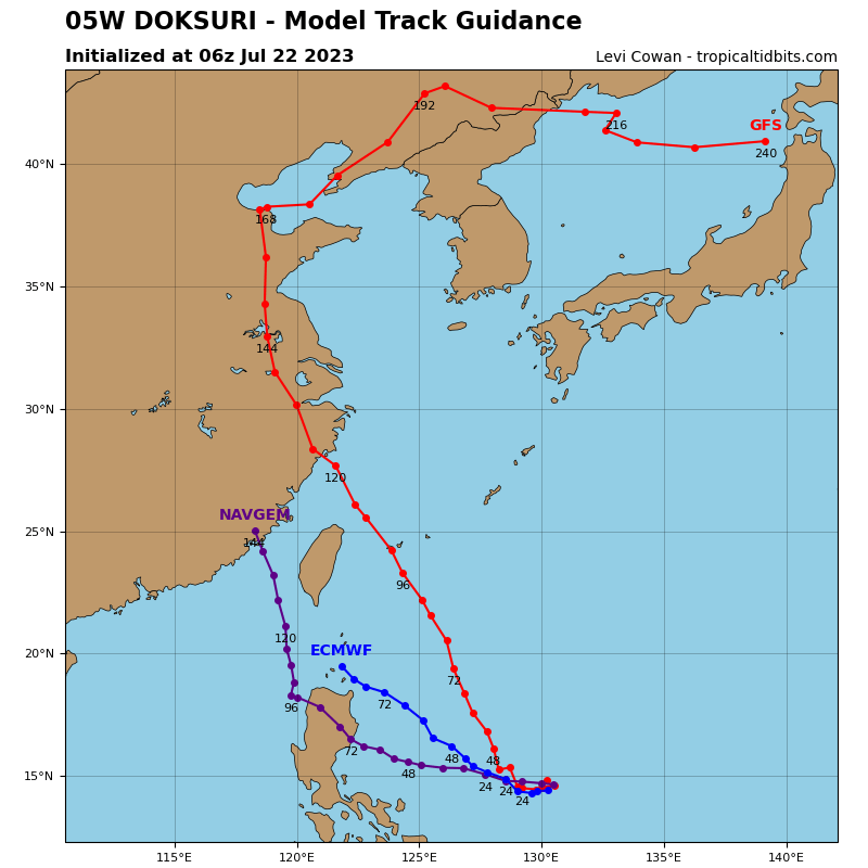
Tropical Cyclone 05W (Doksuri)
According to the JTWC Warning number 6…
Tropical storm 05W (Doksuri) continues to slowly consolidate and intensify, but at a relatively leisurely rate. Animated enhanced infrared (eir) satellite imagery depicts an asymmetric system, with a broad band of deep convection extending from near the assessed low level center (llc) southwestward in a graceful arc. Dry low to mid-level air remains firmly entrenched to the north, which is still inhibiting convective development on the northwestern flank of the circulation. the latest frames of eir confirm that the convection is almost linear in nature and unable to penetrate western side of the circulation. A microwave image is suggestive of some low-level bands beginning to form on the western side of the circulation, but they remain very weak, with broad convective bands wrapping up the eastern side.
The environment continues to improve, with the tutt-cell to the northeast providing some enhanced eastward outflow as well as acting like a blocker running a pick, disrupting the northeasterly flow aloft and reducing effective shear over TS 05W. This lowered shear is allowing for outflow to begin expanding radially outward, especially poleward. shear remains low (5-10 knots) and sea surface temperatures are very warm.
Through the next 24 hours or so, TS 05W will continue to track generally westward under the influence of the deep ridge firmly entrenched to the north. Through this period, the system will slowly but steadily intensify as it continues to consolidate in the low levels and the upper-level outflow pattern continues to evolve in its favor.
By 36 hours, the upper-level steering pattern begins to change as the steering ridge shifts its center position eastward, and the ridging over the East China Sea begins to erode ahead of an approaching upper-level low moving east out of northern China. The combination of effects will allow TS 05W to turn onto a northwestward track after 36 hours, which will continue through the end of the forecast period.
In terms of intensity, the system is expected to intensify at a rate of about 10 knots per 12 hours through 36 hours. After this point, the rate of intensification will dramatically increase. An upper-level low sitting at the base of a sharp trough south of Tokyo at present, will deepen and dive southward and slide southwestward to a point south of Kyushu by 36 hours. The positioning of this cutoff low will provide TS 05W with a robust poleward outflow channel, which will support a period of rapid intensification (ri), kicking off in earnest after 36 hours.
The current peak of 115 knots is expected to occur around or just prior to 96 hours, but further intensification is possible between 96 hours and Taiwan landfall, which cannot be captured in the forecast points. A peak intensity exceeding 120 knots is possible as the system will cross over a pool of very warm waters, which sits just east of Taiwan and will by that time be tapping into a very strong poleward outflow channel.
Landfall along the northern half of Taiwan is expected after 96 hours, with the track after landfall highly uncertain due to terrain induced track variability that depends upon the exact landfall location.
