

")
Tropical Cyclone 05W (Doksuri) / Tropical Cyclone 06W (Khanun)
Friday, July 28, 2023
Current Snapshot
For all the latest updates visit: DisasterAWARE

yyy

kkk
pdcepac2

pdcepac

doksuri

05W_280600sair

05W_tracks_latest

khanun

06W_281200sair

06W_tracks_latest
By PDC’s Senior Weather
Specialist Glenn James

The Pacific Disaster Center’s (PDC Global) Friday, July 28, 2023, Tropical Cyclone Activity Report…for the Pacific Ocean, the Indian Ocean, and adjacent Seas
Current Tropical Cyclones:
Typhoon 05W (Doksuri)…is located approximately 172 NM west-northwest of Taipei, Taiwan – Final Warning
Tropical Cyclone 06W (Khanun)…is located approximately 668 NM south-southeast of Kadena AB, Okinawa, Japan
Northeast Pacific Ocean:
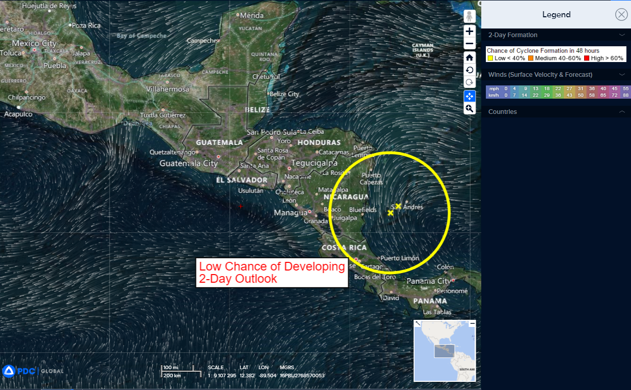
>>> Offshore of Southern Mexico…
A tropical wave located over Central America is producing a large area of showers and thunderstorms.
The system is forecast to move across Central America and over the eastern Pacific during the next day or so, and an area of low pressure is expected to form off the coast of southern Mexico later this weekend.
Thereafter, gradual development of this system is forecast and a tropical depression will likely form while it moves generally west-northwestward at 10 to 15 mph, roughly parallel to the coasts of southern and southwestern Mexico.
* Formation chance through 48 hours…low…20 percent
* Formation chance through 7 days…high…80 percent
Central Pacific Ocean:
There are no tropical cyclones
Western Pacific, Indian Ocean and adjacent Seas:
Typhoon 05W (Doksuri) – Final Warning
According to the JTWC Warning number 28…
Sustained winds were 75 knots…with gusts to near 90 knots
Animated multi-spectral satellite imagery and rising objective intensity assessments confirm Typhoon Doksuri is making an 11th hour surge prior to landfall.
The system will be making landfall near Quanzhou, China during the next 1-2 hours.
Due to a combination of spectacular dual-channel outflow and warming near-shore sea waters induced by downwelling ahead of the storm, Typhoon Doksuri will continue to intensify until it makes landfall during the next 1-2 hours. It will then decay rapidly on its overland track and is not expected to regenerate over the Gulf of Bohai.
Tropical Cyclone 06W (Khanun)
According to the JTWC Warning number 8…
Sustained winds were 40 knots…with gusts to near 50 knots
Animated enhanced infrared satellite imagery shows that tropical storm 06W (Khanun) is having a hard time consolidating in the face of persistent northerly shear and mid to upper-level dry air pressing down from the north and west. Animated shortwave infrared imagery shows the primary low level vortex is now exposed in the middle of an area of disorganized convection flaring around the periphery of the broader circulation. A timely microwave image provided high confidence in the assessment of the initial position and that this vortex is the primary one.
Through the first 36 hours of the forecast, TS 06W is expected to track generally towards the north-northwest along the periphery of the ridge to the east. Short-term wobbles and excursions left and right of the forecast track are to be anticipated as the vortex structure continues to consolidate but the overall track made good will be towards the north-northwest.
By 36 hours the steering pattern will begin to shift, as the ridge slides towards the southwest, handing the baton to the strong subtropical ridge lying on an east-west axis from Tokyo to Seoul and into northern China. By 72 hours, the ridge becomes the primary steering influence and TS 06S will turn onto a more west-northwest track through the remainder of the forecast. Track speeds are expected to slow as the system passes Okinawa as the ridge to the north weakens and the system moves into a weaker steering environment. A very close passage to Okinawa is expected by 72 hours with a landfall in the vicinity of Shanghai forecast by 120 hours.
In terms of intensity, the slow pace of intensification is expected to continue for the next 36 to 48 hours, as the wedge of dry mid and upper-level air is forecast to penetrate further into the circulation on the western side, offsetting improved poleward outflow into a tutt-cell which kicks off around 18 hours.
All global and mesoscale models agree that by 48 hours the dry air is pushed aside, and coincides with both the consolidation of the low-level core and the peak in the poleward outflow. This congruence of improved environmental parameters will allow for a burst of rapid intensification between 48 and 72 hours, with the intensity forecast to increase from 60 to 100 knots within this 24 hour period.
By 72 hours, the development of an upper-level anticyclone just north of the system will introduce easterly convergent flow around the system, but the system is expected to be strong enough by that time to put up a good fight against this malign influence, and is forecast to continue to strengthen slightly prior to landfall in eastern China. After slowly moving ashore south of Shanghai, the system will rapidly weaken due to terrain effects and increased shear.
