

")
Tropical Cyclone Hilary / Invest 05E
Saturday, August 19, 2023
Current Snapshot
For all the latest updates visit: DisasterAWARE

1800×10805

1800×10806

pdchilary

hilarysat

144510_earliest_reasonable_toa_34

144510WPCQPF_sm

144510WPCERO_sm

09E_tracks_latest
pdclow

pdcdora
By PDC’s Senior Weather
Specialist Glenn James

The Pacific Disaster Center’s (PDC Global) Saturday, August 19, 2023, Tropical Cyclone Activity Report…for the Pacific Ocean, the Indian Ocean, and adjacent Seas
Current Tropical Cyclones:
Tropical Cyclone 09E (Hilary)…is located about 600 miles south-southeast of San Diego, California
Northeast Pacific Ocean:
Tropical Cyclone 09E (Hilary)
HEAVY RAINS SPREADING NORTHWARD OVER THE BAJA PENINSULA AND THE SOUTHWESTERN UNITED STATES…CATASTROPHIC AND LIFE-THREATENING FLOODING LIKELY
According to the NHC advisory number 14A…
Hilary is moving toward the north-northwest near 17 mph (28 km/h). The hurricane is expected to accelerate as it moves north-northwestward to northward during the next day or two. On the forecast track, the center of Hilary will move close to the west-central coast of the Baja California Peninsula tonight and Sunday morning then move across southern California Sunday afternoon and Sunday night.
Maximum sustained winds are near 100 mph (155 km/h) with higher gusts. Continued weakening is expected, but Hilary will still be a hurricane when it approaches the west coast of the Baja California Peninsula tonight. Hilary is expected to weaken to a tropical storm before it reaches southern California.
Hurricane-force winds extend outward up to 45 miles (75 km) from the center and tropical-storm-force winds extend outward up to 265 miles (425 km). A sustained wind of 46 mph (74 km/h) and a gust of 58 mph (93 km/h) were recently reported at Loreto, Mexico.
HAZARDS AFFECTING LAND
RAINFALL: Hilary is expected to produce storm total rainfall amounts of 3 to 6 inches, with isolated maximum amounts up to 10 inches, across portions of the northern Baja California Peninsula through Sunday night. Flash and urban flooding, locally catastrophic, is expected, especially in the northern portions of the peninsula.
Heavy rainfall is expected across the Southwestern United States, peaking late tonight through Sunday night. Rainfall amounts of 3 to 6 inches, with isolated amounts of 10 inches, are expected across portions of southern California and southern Nevada. Dangerous to catastrophic flooding is expected. Elsewhere across portions of the Western United States, rainfall totals of 1 to 3 inches are expected, resulting in localized, some significant, flash flooding.
WIND: Hurricane conditions are expected within the hurricane warning area tonight and early Sunday and are possible within the hurricane watch Sunday. Tropical storm conditions are occurring within the southern portion of the tropical storm warning area and will spread northward today and Sunday. Tropical storm conditions are possible within the tropical storm watch area through tonight. Tropical storm conditions are expected to begin in southern California Sunday afternoon.
Winds could be particularly strong and gusty in and near areas of elevated terrain. Higher gusts are expected well inland near and along the forecast track.
STORM SURGE: A dangerous storm surge is likely to produce coastal flooding along the western Baja California peninsula of Mexico near where the center passes the coast in areas of onshore winds, or east of the center if Hilary makes landfall. The surge will be accompanied by large and destructive waves. Coastal flooding is possible along the northern coast of the Gulf of California Sunday through early Monday.
TORNADOES: A tornado or two may occur Sunday from mid-morning through the evening over parts of the lower Colorado River Valley, Mojave Desert, and Imperial Valley regions.
SURF: Large swells generated by Hilary will affect portions of the Baja California Peninsula and southern California over the next couple of days. These swells are likely to cause life-threatening surf and rip current conditions.
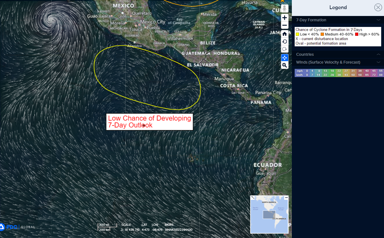
>>> South of Southern Mexico…
A broad area of low pressure could form offshore of the coast of southern Mexico during the early or middle part of next week. Development of this system, if any, should be slow to occur while it moves toward the west-northwest or northwest.
* Formation chance through 48 hours…low…near 0 percent
* Formation chance through 7 days…low…20 percent
Western Pacific, Indian Ocean and adjacent Seas:
Western Pacific…
>>> There’s an area of disturbed weather being referred to as Invest 05E…which is located approximately 1386 NM east of Yokosuka, Japan.
The system is currently classified as a subtropical depression, generally characterized as having both tropical and mid-latitude cyclone features.
Animated multi-spectral satellite imagery depict an elongated circulation with deepest convection displaced 40 NM to the southeast of the circulation.
Environmental analysis reveals unfavorable conditions for tropical transition with warm sea surface temperatures and strong equatorward outflow aloft greatly offset by high (30 knot) vertical wind shear and dry air being advected into the circulation.
Global models are in general agreement that Invest 05E will track northeastward with a broad and asymmetric wind field.
Maximum sustained surface winds are estimated at 20 to 25 knots.
The potential for the development of a significant tropical cyclone within the next 24 hours remains low.
