

")
Post-Tropical Cyclone Hilary / Invest 05E / Invest 90W
Monday, August 21, 2023
Current Snapshot
For all the latest updates visit: DisasterAWARE

1000×10006

1000×10007

goes18_ir_09E_202308211615_lat40.6-lon-118.0sathilary

09E_tracks_latesthilary

pdc7day
pdcwpac
By PDC’s Senior Weather
Specialist Glenn James

The Pacific Disaster Center’s (PDC Global) Monday, August 21, 2023, Tropical Cyclone Activity Report…for the Pacific Ocean, the Indian Ocean, and adjacent Seas
Current Tropical Cyclones:
Post-Tropical Cyclone 09E (Hilary)…is located about 265 miles north of Elko, Nevada
Northeast Pacific Ocean:
Post-Tropical Cyclone 09E (Hilary)
ISOLATED FLOODING AND GUSTY WINDS WILL CONTINUE AS THE VESTIGES OF HILARY CROSS THE NORTHERN ROCKIES THIS EVENING
According to the NHC advisory number 22…
The post-tropical cyclone is moving toward the northeast near 32 mph (52 km/h) and this motion is expected to continue into the evening.
Maximum sustained winds are near 30 mph (45 km/h) with higher gusts. Continued weakening is forecast during the next 12 hours with the low center becoming ill-defined later tonight.
HAZARDS AFFECTING LAND
RAINFALL: Rainfall totals of 1 to 2 inches with local maxima of 3 inches will be possible through early Tuesday morning across the central and northern portions of the Intermountain West as well as portions of northern Arizona into central Utah. Isolated flash and urban flooding is possible.
A list of rainfall observations compiled by the NOAA Weather Prediction Center for this storm can be found at:
www.wpc.ncep.noaa.gov/discussions/nfdscc4.html
WIND: The broad circulation associated with Hilary is still expected to produce strong, gusty winds in Nevada, western Utah, southern Idaho, and southwest Montana. The strongest gusts will be favored in higher terrain, passes, and canyons, as well as in proximity to thunderstorms.
>>> South of Southern Mexico…
A broad area of low pressure is expected to form offshore of the coast of Central America or southern Mexico during the next few days.
Environmental conditions appear generally favorable for gradual development of this system, and a tropical depression could form late this week while it moves slowly northwest to
north-northwest.
* Formation chance through 48 hours…low…near 0 percent
* Formation chance through 7 days…medium…40 percent
Western Pacific, Indian Ocean and adjacent Seas:
Western Pacific…
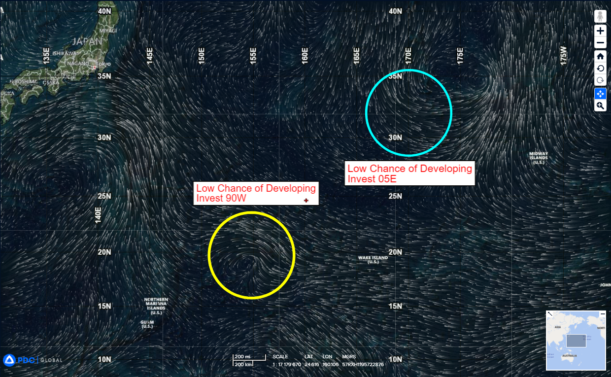
>>> There’s an area of disturbed weather being referred to as Invest 05E…which is located approximately 483 NM northwest of Midway Island
The system is currently classified as a subtropical depression, generally characterized as having both tropical and mid-latitude cyclone features.
Animated multi-spectral satellite imagery depict an elongated circulation with isolated convection displaced to the southeast of the low level circulation center.
Environmental analysis reveals unfavorable conditions for tropical transition with warm sea surface temperatures and strong equatorward outflow aloft offset by low (10-15 knot) vertical wind shear and dry air being advected into the circulation.
Global models are in general agreement that Invest 05E will track poleward and eastward with a broad and asymmetric wind field.
Maximum sustained surface winds are estimated at 20 to 25 knots.
The potential for the development of a significant tropical cyclone within the next 24 hours remains low.
>>> There’s a second area of disturbed weather being referred to as Invest 90W…which is located approximately 615 NM northeast of Guam
Animated multi-spectral satellite imagery depict a consolidating low level circulation center (llcc) with isolated convection to the northeast. A microwave pass shows a weak llcc which shows the eastern portion of a 15 knot circulation.
Environmental analysis reveals favorable conditions for development with warm sea surface temperatures, strong
poleward outflow aloft and low (10-15 knot) vertical wind shear.
Global models are in good agreement that the system will slowly consolidate over the next 48 hours.
Maximum sustained surface winds are estimated at 18 to 23 knots.
The potential for the development of a significant tropical cyclone within the next 24 hours is upgraded to medium.
