

")
Tropical Cyclone 08W (Damrey) / Tropical Cyclone 09W (Saola) / Invest 91E / Invest 92E
Thursday, August 24, 2023
Current Snapshot
For all the latest updates visit: DisasterAWARE

1800x1080e

1800x1080f

epac2

epac7

sat91e

91E_tracks_latest

sat92

92E_gefs_latest

pdc08w

jtwc08wsat

08W_tracks_latest
pdc09w

jtwc09wsat

jtwcsat09

09W_tracks_latest
By PDC’s Senior Weather
Specialist Glenn James

The Pacific Disaster Center’s (PDC Global) Thursday, August 24, 2023, Tropical Cyclone Activity Report…for the Pacific Ocean, the Indian Ocean, and adjacent Seas
Current Tropical Cyclones:
Tropical Cyclone 08W (Damrey)…is located approximately 325 NM south of Minami Tori Shima
Tropical Cyclone 09W (Saola)…is located approximately 349 NM south-southeast of Taipei, Taiwan
Northeast Pacific Ocean:
>>> South of Southwestern Mexico…
Invest 91L
A trough of low pressure located several hundred miles south of the southern and southwestern coast of Mexico is producing disorganized shower and thunderstorm activity. Environmental conditions appear marginally conducive for some slow development of this system, and a tropical depression could form during the next few days while it moves slowly northwestward or northward toward southwestern Mexico. Interests in southwestern Mexico should monitor the progress of this
system.
* Formation chance through 48 hours…low…20 percent
* Formation chance through 7 days…medium…40 percent
>>> Central East Pacific…
Invest 92L
Satellite imagery indicates a low pressure system located well south of the southern tip of the Baja California Peninsula is gradually becoming better defined. The system continues to produce some showers and thunderstorms, and environmental conditions are expected to become more favorable for additional development of this system during the next day or so. A tropical depression is likely to form during the next couple of days while it moves west-northwestward at 10 to 15 mph over the central portion of the tropical eastern Pacific.
* Formation chance through 48 hours…high…70 percent
* Formation chance through 7 days…high…80 percent
Western Pacific, Indian Ocean and adjacent Seas:
Western Pacific…
Tropical Cyclone 08W (Damrey)
According to the JTWC Warning number 9…
Sustained winds were 40 knots…with gusts to near 50 knots
Animated enhanced infrared satellite imagery depicts a fully obscured low level circulation center with deep convection limited to the eastern and southern semicircles. A partial microwave image shows a large monsoon depression sized circulation with a small weak circulation center devoid of deep convection.
TD 08W, having recently executed an about-face is now tracking generally eastward and is forecast to be tracking east-northeastward and eventually northward by 24 hours, under the growing influence of the ridge to the east.
By 36 hours, the system will be tracking generally north-northwestward and slightly intensifying as the upper level outflow begins to improve.
Near 48 hours, the system will begin to accelerate north-northwestward as a ridge builds to the north. As the system rides this ridge poleward, the very large monsoon depression sized circulation will struggle to gain any notable intensity.
By 120 hours, as the system passes well east of Tokyo Japan, the system will be approximately 40 knots as it nears the axis of the ridge.
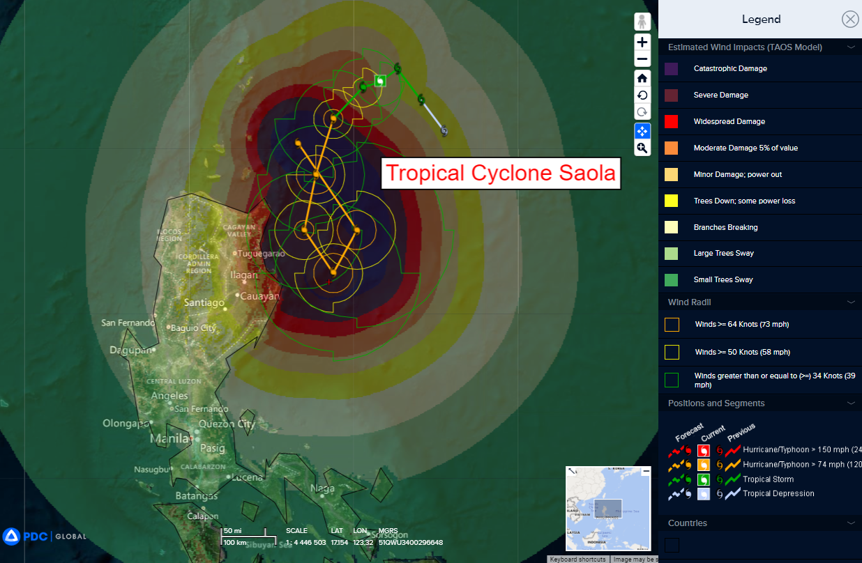
Tropical Cyclone 09W (Saola)
According to the JTWC Warning number 6…
Sustained winds were 55 knots…with gusts to near 70 knots
Animated enhanced infrared satellite imagery depicts a partially exposed low level circulation center (llcc) with a bulk of the deep convection limited to the eastern and southern quadrants. This exposed western quadrant is due to persistent northerly flow advecting cool dry air into the system. A microwave image reveals a claw shaped deep convective band struggling to wrap the core of the circulation.
TS 09W (Saola) is forecast to begin a poleward course change within the coming hours. as the ridge to the east breaks down and the ridge to the west builds up, the system will be forced to alter course. As this transfer happens, the system will make a sharp equatorward turn and maintain that course until roughly 72 hours.
After passing equatorward of 18N, a near equatorial ridge builds due south of the system, halting all forward progress and sharply turning the system poleward. By 96 hours and through 120 hours, this ridge forces 09W northward and eventually north-northwestward towards the Luzon Straits.
In terms of intensity, 09W is forecast to begin to rapid intensify (ri) within the next 12 hours. Northerly shear is the primary limiting factor, so as 09W intensifies, its ability to cocoon itself and generally shield its core from this northerly pressure will greatly aid the systems ability to intensify.
By 24 hours, fueled by soup-like sea surface temperatures, and highly favorable atmospheric conditions, 09W will quickly achieve typhoon strength and continue to intensity to an estimated 105 knots by 72 hours. As the system executes the complicated barrel role that will track it towards the Luzon Straights, there is a chance for a duration of near quasi-stationary (qs) movement near 72 hours.
A qs period may limit further intensification due to upwelling of cooler waters, but this effect would quickly be negated once poleward motion is once again achieved. As it stands, JTWC is forecasting a peak intensity near 120 knots by 120 hours.
