

")
Post-Tropical Cyclone 10E (Irwin) / Tropical Cyclone 09W (Saola) / Tropical Cyclone 10W (Haikui) / Invest 94W
Tuesday, August 29, 2023
Current Snapshot
For all the latest updates visit: DisasterAWARE

1800x1080z

1800x1080zz

pdcepac

tsatirwin

143821_earliest_reasonable_toa_34irwin

10E_tracks_latestirwin

cpac7

wpac2

jtwcsatsaola

tsatsaola

tsaola

jtwcsathaikui

10W_tracks_latesthaikui
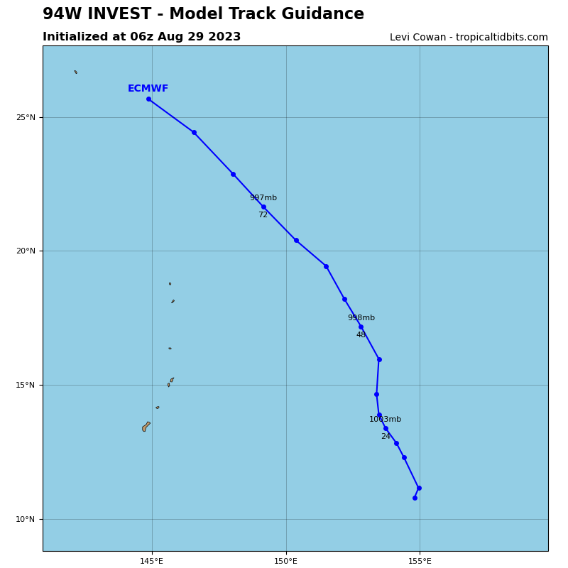
94W_tracks_latest
By PDC’s Senior Weather
Specialist Glenn James

The Pacific Disaster Center’s (PDC Global) Tuesday, August 29, 2023, Tropical Cyclone Activity Report…for the Pacific Ocean, the Indian Ocean, and adjacent Seas
Current Tropical Cyclones:
Post-Tropical Cyclone 10E (Irwin)…is located about 1340 NM west of the southern tip of Baja California – Last Advisory
Tropical Cyclone 09W (Saola)…is located approximately 313 NM south of Taipei, Taiwan
Tropical Cyclone 10W (Haikui)…is located approximately 423 NM southwest of Iwo To
Northeast Pacific Ocean:
Post-Tropical Cyclone 10E (Irwin) – Last Advisory
IRWIN BECOMES A POST-TROPICAL CYCLONE/strong>
According to the NHC advisory number 12…
The post-tropical cyclone is moving toward the west near 17 mph (28 km/h). This general motion with a gradual decrease in forward speed is expected over the next few days.
Satellite wind data indicate that maximum sustained winds are near 40 mph (65 km/h) with higher gusts. Gradual weakening is forecast during the next few days.
Tropical-storm-force winds extend outward up to 70 miles (110 km) to the northwest of the center.
Central North Pacific…
The National Hurricane Center in Miami, Florida is issuing advisories on Tropical Storm Irwin, centered around 1700 miles east of Hilo, Hawaii. Irwin is forecast to move into the Central Pacific Hurricane Center area of responsibility as a post-tropical remnant low on Friday.
>>> Approximately 750 miles south-southeast of Hilo, Hawaii...
A broad area of low pressure is producing disorganized showers and thunderstorms. This system is moving west-southwestward at 10 to 15 mph into unfavorable environmental conditions, and tropical cyclone formation is becoming less likely.
* Formation chance through 48 hours…low…10 percent
* Formation chance through 7 days…low…10 percent
Elsewhere, no tropical cyclones are expected during the next 7 days.
Western Pacific, Indian Ocean and adjacent Seas:
Western Pacific…
Tropical Cyclone 09W (Saola)
According to the JTWC Warning number 25…
Sustained winds were 135 knots…with gusts to near 165 knots
Super Typhoon (sty) 09W (Saola) has literally exploded over the past 12 hours, going from a moderate typhoon without an eye, to a 135 knot sty with a 21 NM wide stadium eye. Unfortunately, the Philippine radar network over northeastern Luzon appears to be down, but regardless, the large stadium eye in the enhanced infrared imagery and a microwave image show a very well-organized system, with a singular wide band of convection completely surrounding the eye feature.
Clearly, the environment is conducive to rapid intensification (ri), with zesty sea surface temperatures which have recovered from the weak upwelling induced by traverse of sty 09W through this same region four days ago. Outflow is radial but relatively confined to the region around the storm itself with no clear outflow channels. Analysis indicates 21 knots of easterly shear, which may in fact be present, but analysis of earlier water vapor imagery shows an outflow arc extending eastward and a subsident area east of that; a classical setup for ri in a moderate easterly shear environment, which occurred in very rapid succession to the actual onset of the ri.
STY 09W has exceeded all expectations, and undergone extreme rapid intensification, exploding from near 100 knots to 135 knots 12 hours later. As the system traverses the northern Babuyan Islands over the next 12 hours, it is likely to intensify another few knots, with the forecast peaking out at 140 knots by 12 hours. The system will then continue tracking west-northwest into the northern portion of the South China Sea (scs) through 48 hours, passing well south of Taiwan on its way towards the Chinese coast under the steering influence of the ridge centered far to the northeast.
Around 48 hours, a relatively deep mid-latitude trough will pass by to the north, but will remain far enough to the north to not influence the track of STY 09W all that much. The transient anticyclone that develops in the wake of this trough, however will have an impact, turning the system onto a more westward track by 48 hours. The transient anticyclone quickly moves northeast and is absorbed into the larger ridge complex, but leaves behind a sharp ridge which extends all the way from southern China to 40N 160E. This ridge pattern will serve to push STY 09W onto a west-southwest track from 72 hours onward, with the track skirting the coast near Hong Kong by 96 hours then opening the distance to the coast thereafter.
In terms of intensity, as mentioned, the system is forecast to peak at 140 knots within the next 12 hours. The system is forecast to weaken as it tracks southwest of Taiwan, but then maintain intensity as it taps into a modest poleward outflow channel around 48 hours. By 72 hours, the system begins to feel the effects to cooler waters, ingestion of dry continental air from mainland China and an increase in mid-level shear, marking the beginning of a steady weakening trend that continues through the end of the forecast period.
Tropical Cyclone 10W (Haikui)
According to the JTWC Warning number 6…
Sustained winds were 55 knots…with gusts to near 70 knots
Animated enhanced infrared and visible satellite imagery depicts a partially exposed low level circulation center (llcc) to the east of an area of persistent convection with robust overshooting tops. While the convection is impressive, based on the visible imagery, the vortex is significantly tilted to the west with height due to persistent moderate easterly shear.
The system is tracking westward along the southern side of a deep-layer subtropical ridge (str) to the north. Environmental analysis reveals roughly favorable conditions, with warm sea surface temperatures and good westward and equatorward outflow offset by the moderate easterly shear.
A reanalysis of earlier microwave imagery has resulted in a slowing in the track speed, but no major shift in the track direction, with tropical storm 09W (Haikui) still heading towards the west-northwest along the southern side of the strong str far to the northeast. Continuing the trend established six hours ago, model guidance continues to diverge at a steadily increasing rate, with the divergence beginning as early as 36 hours. The key difference from six hours ago is that the ecmwf and its ensemble are now the sole outliers in taking the system on a path straight at Okinawa and onwards into the East China Sea. The remainder of the guidance insists the system will turn sharply southwest after 36 hours, perform a counter-clockwise loop, and then track back to the northeast under the influence of a strengthening ridge over eastern China, and an interaction with a potential future tropical cyclone developing east of Guam.
Shear is expected to remain at moderate levels for the next 24 hours or so and will put a brake on vortex alignment and intensification. shear is expected to relax somewhat after 24 hours, allowing the system to intensify at a faster rate, reaching a peak of 95 knots by 72 hours. However, due to the extreme uncertainty in the track, the intensity guidance is also highly uncertain due to the relationship between the track and intensity.
>>> There’s an area of disturbed weather being referred to as Invest 94W…which is located approximately 541 NM east-southeast of Guam
Animated multi-spectral infrared imagery and a microwave pass depict deep convective lines on the east and western flanks, wrapping into a mostly obscured low level circulation center. A scatterometry pass revealed 15- 20 knot winds surrounding an elongated area of rotation.
Environmental analysis reveals a favorable conditions for intensification due to low (10-15 knot) vertical wind shear, warm sea surface temperatures, and good poleward and equatorward outflow.
Global models agree that 94W will intensify along a northerly track before recurving to the northwest around the Northern Marianas Islands.
Maximum sustained surface winds are estimated at 18 to 23 knots.
The potential for the development of a significant tropical cyclone within the next 24 hours is upgraded to high.
