

")
Tropical Cyclone Gert / Tropical Cyclone 12L (Katia)
Saturday, September 2, 2023
Current Snapshot
For all the latest updates visit: DisasterAWARE

1800×10802

1800×10803
pdcatl

tsatida

10L_tracks_latestida

tsatgert

06L_tracks_latestgert

tsatkat

12L_tracks_latestkat

pdc95l

pdc95L7
By PDC’s Senior Weather
Specialist Glenn James

The Pacific Disaster Center’s (PDC Global) Saturday, September 2, 2023, Tropical Cyclone Activity Report…for the Atlantic Ocean, the Caribbean Sea, and the Gulf of Mexico
CURRENT TROPICAL CYCLONES:
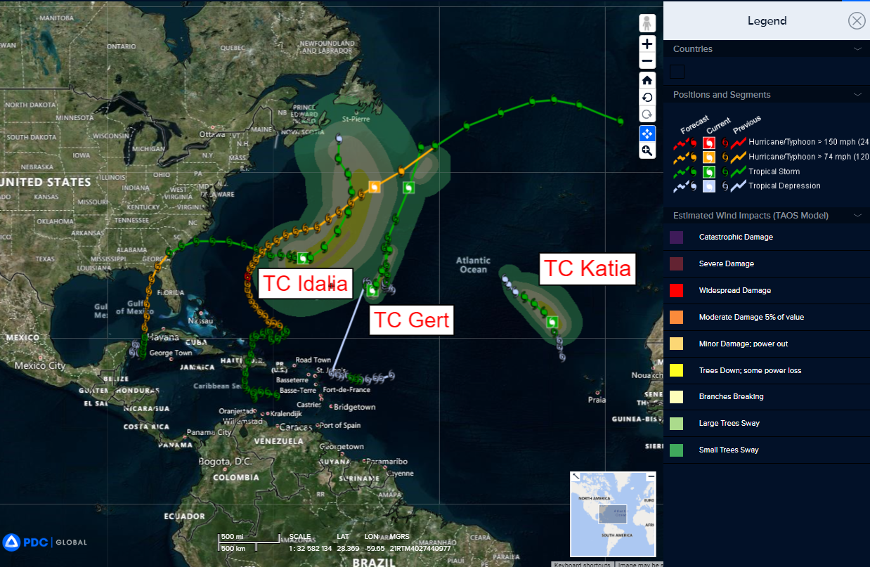
Tropical Cyclone Gert…is located about 710 miles east-southeast of Bermuda
Tropical Cyclone 12L (Katia)…is located about 855 miles north-northwest of Cabo Verde Islands
Tropical Cyclone Gert
GERT STRENGTHENS A LITTLE MORE
According to the NHC Advisory number 21…
Gert is moving toward the north-northeast near 6 mph (9 km/h). A faster north-northeastward motion is expected during the next day or so.
Maximum sustained winds are near 60 mph (95 km/h) with higher gusts. No significant change in strength is expected before Gert is forecast to generate into a trough of low pressure early Monday.
Tropical-storm-force winds extend outward up to 60 miles (95 km) from the center.
Tropical Cyclone 12L (Katia)
KATIA’S THUNDERSTORMS DECREASING
According to the NHC Advisory number 7…
Katia is moving toward the north-northwest near 16 mph (26 km/h). A turn to the northwest is expected shortly, and this general motion with a decrease in forward speed is expected through Monday.
Maximum sustained winds have decreased to near 45 mph (75 km/h) with
higher gusts. Gradual weakening is expected, and the system could degenerate into a remnant low on Monday.
Tropical-storm-force winds extend outward up to 80 miles (130 km) from the center.
>>> Eastern and Central Tropical Atlantic…
A tropical wave located over the far eastern tropical Atlantic is producing disorganized shower and thunderstorm activity to the south of the Cabo Verde Islands. Environmental conditions appear conducive for some gradual development of this system by the middle part of next week, and a tropical depression is likely to form while it moves westward to west-northwestward at 15 to 20 mph over the eastern and central portions of the tropical Atlantic.
* Formation chance through 48 hours…low…30 percent
* Formation chance through 7 days…high…70 percent
