

")
Tropical Cyclone 13L (Lee) / Tropical Cyclone 14L (Margot) / Invest 97L / Invest 98L
Tuesday, September 12, 2023
Current Snapshot
For all the latest updates visit: DisasterAWARE

1800x1080uu

1800x1080uuu
pdcatlantic

tsatlee

144241_earliest_reasonable_toa_34lee

13L_tracks_latestlee

goes16_ir_14L_202309121445_lat29.6-lon-39.4margot

145119_earliest_reasonable_toa_34margot

14L_tracks_latestmargot

pdc2

7
By PDC’s Senior Weather
Specialist Glenn James

The Pacific Disaster Center’s (PDC Global) Tuesday, September 12, 2023, Tropical Cyclone Activity Report…for the Atlantic Ocean, the Caribbean Sea, and the Gulf of Mexico
CURRENT TROPICAL CYCLONES:
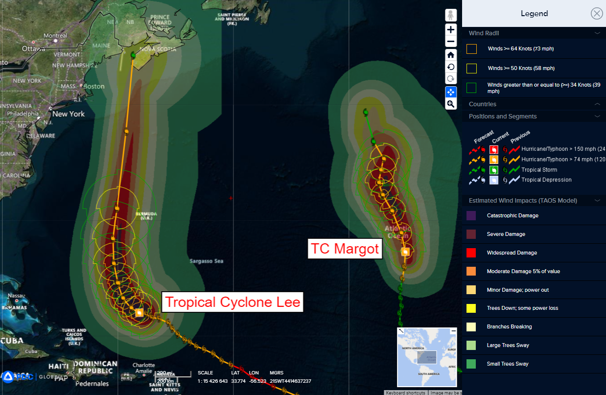
Tropical Cyclone 13L (Lee)…is located about 495 miles south-southwest of Bermuda
Tropical Cyclone 14L (Margot)…is located about 800 miles west-southwest of the Azores
Atlantic Ocean
Tropical Cyclone 13L (Lee)
LEE CHURNING UP THE WESTERN ATLANTIC WITH DANGEROUS SEAS
According to the NHC advisory number 31A…
Lee is moving toward the northwest near 7 mph (11 km/h). Lee is forecast to turn toward the north on Thursday and increase in forward speed.
Maximum sustained winds are near 115 mph (185 km/h) with higher gusts. Lee is a category 3 hurricane on the Saffir-Simpson Hurricane Wind Scale. Some slow weakening is forecast during the next 48 hours, however Lee is likely to remain a large and dangerous hurricane for the next couple of days.
Lee is a very large hurricane. Hurricane-force winds extend outward up to 125 miles (205 km) from the center and tropical-storm-force winds extend outward up to 240 miles (390 km). Saildrone 1036, located about 45 miles (75 km) west-northwest of Lee’s center, recently reported a sustained wind of 68 mph (109 km/h), a wind gust to 88 mph (142 km/h), and a significant wave height of 37 feet (11.4 meters).
HAZARDS AFFECTING LAND
WIND: Tropical storm force winds are possible on Bermuda starting Thursday morning.
SURF: Swells generated by Lee are affecting portions of the Lesser Antilles, the British and U.S. Virgin Islands, Puerto Rico, Hispaniola, the Turks and Caicos Islands, the Bahamas, and Bermuda. These swells are likely to cause life-threatening surf and rip current conditions. Dangerous surf and rip currents are affecting portions of the southeastern U.S. coast, and these conditions are forecast to spread northward along much of the U.S. East Coast during the next couple of days.
RAIN: Outer rain bands from Lee may produce rainfall amounts of 1 to 2 inches, 25 to 50 millimeters, across Bermuda Thursday into early Friday.
Tropical Cyclone 14L (Margot)
MARGOT A LITTLE STRONGER
According to the NHC advisory number 23…
Margot is moving toward the north near 12 mph (19 km/h). A north-northwestward or northward motion with a gradual decrease in forward speed is expected over the next couple of days. A slow meandering motion is expected on Friday and into the weekend.
Maximum sustained winds have increased to near 85 mph (140 km/h) with higher gusts. Slight fluctuations in intensity are possible during the next several days.
Hurricane-force winds extend outward up to 80 miles (130 km) from the center and tropical-storm-force winds extend outward up to 265 miles (425 km).
HAZARDS AFFECTING LAND
SURF: Swells generated by Margot will begin to affect the Azores on
Wednesday. These swells are likely to cause life-threatening surf and rip current conditions.
>>> Eastern and Central Tropical Atlantic…
Invest 97L
A broad area of low pressure over the eastern tropical Atlantic continues to produce some disorganized showers and thunderstorms.
Gradual development of this system is expected over the next few days while the system moves west-northwestward to northwestward at 10 to 15 mph, and a tropical depression is likely to form by this weekend over the central tropical Atlantic.
* Formation chance through 48 hours…medium…40 percent
* Formation chance through 7 days…high…80 percent
