

")
Tropical Cyclone 06L (Gert) / Tropical Cyclone 08L (Franklin) / Tropical Cyclone 09L (Harold) / Invest 92L
Monday, August 21, 2023
Current Snapshot
For all the latest updates visit: DisasterAWARE

1800×10801

1800×10802

1000×10003

1000×10004
pdcatl

pdc09L

92L2

92L7

satgert

145250_earliest_reasonable_toa_34gert

satfrank

144827_earliest_reasonable_toa_34frank

08L_tracks_latestrank

92Lsat

92L_tracks_latest

sat09L

144156_earliest_reasonable_toa_3409L

09L_tracks_latest
By PDC’s Senior Weather
Specialist Glenn James

The Pacific Disaster Center’s (PDC Global) Monday, August 21, 2023, Tropical Cyclone Activity Report…for the Atlantic Ocean, the Caribbean Sea, and the Gulf of Mexico
CURRENT TROPICAL CYCLONES:
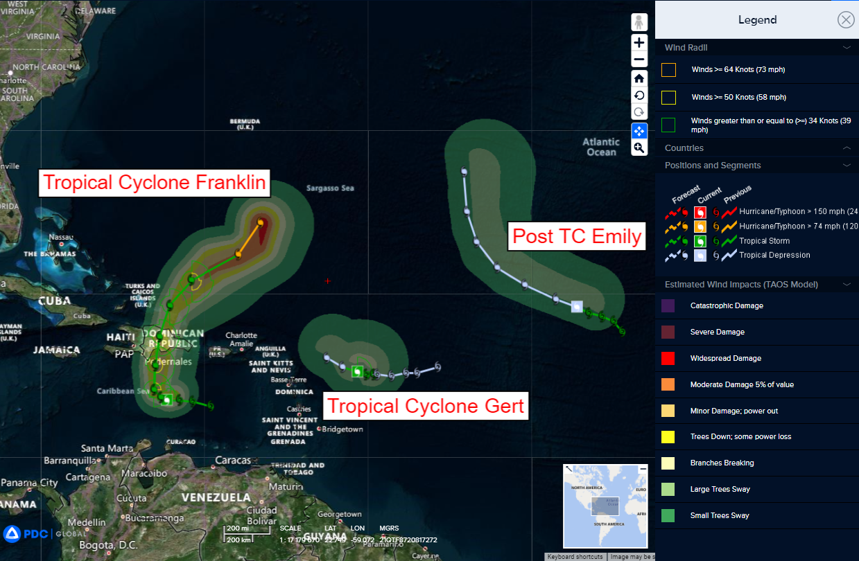
Tropical Cyclone 06L (Gert)…is located about 320 miles east-southeast of the northern Leeward Islands
Tropical Cyclone (Franklin)…is located about 275 miles south of Santo Domingo, Dominican Republic
Tropical Cyclone 09L (Harold)…is located about 195 miles east-southeast of Port Mansfield, Texas
Tropical Cyclone 06L (Gert)
GERT HOLDING ON AS A TROPICAL CYCLONE…COULD DISSIPATE OR BECOME POST TROPICAL AT ANY TIME
According to the NHC Advisory number 11…
The depression is moving toward the west-northwest near 9 mph (15 km/h). Gert or its remnants should turn northwestward overnight or tomorrow.
Maximum sustained winds are near 30 mph (45 km/h) with higher gusts.
Gert could dissipate at any time.
Tropical Cyclone 09L (Franklin)
FRANKLIN MOVING SLOWLY
According to the NHC Advisory number 6A…
Franklin is moving toward the north-northwest near 5 mph (7 km/h). Franklin has been meandering in the eastern Caribbean tonight. Franklin should turn northward on Tuesday with this general motion continuing into Wednesday. On the forecast track, the center of Franklin is forecast to reach the southern coast of Hispaniola by on Wednesday.
Maximum sustained winds remain near 50 mph (85 km/h) with higher gusts. Some strengthening is forecast before Franklin reaches Hispaniola.
Tropical-storm-force winds extend outward up to 70 miles (110 km) from the center.
HAZARDS AFFECTING LAND
RAINFALL: Franklin is expected to produce rainfall amounts of 2 to 4 inches, with isolated higher amounts of 6 inches, across Puerto Rico through the middle of the week. Rainfall amounts of 5 to 10 inches, with isolated higher amounts up to 15 inches, will be possible across portions of Hispaniola.
WIND: Tropical storm conditions are expected to begin within the warning area on Tuesday and are possible within the watch area beginning late Tuesday into Wednesday.
STORM SURGE: A storm surge will raise water levels by as much as 1 to 3 feet above ground level along the immediate coast near and to the east of where the center makes landfall in Hispaniola.
Tropical Cyclone 09L (Harold)
TROPICAL DEPRESSION MOVING QUICKLY TOWARD SOUTH TEXAS…FORECAST TO BRING TROPICAL-STORM-FORCE WINDS AND HEAVY RAINS BEGINNING EARLY TUESDAY
According to the NHC advisory number 3A…
The depression is moving toward the west-northwest near 18 mph (30 km/h). This general motion is expected to continue through Tuesday, and the system is forecast to move inland over south Texas by mid-day Tuesday.
Maximum sustained winds remain near 35 mph (55 km/h) with higher gusts. Strengthening is forecast, and the system is expected to become a tropical storm before it reaches the Texas coast.
>>> Eastern Tropical Atlantic…
Disorganized showers and thunderstorms located a few hundred miles west of the Cabo Verde Islands are associated with a tropical wave.
Environmental conditions appear generally conducive for gradual development of this system, and a tropical depression is likely to form later this week while it moves west-northwestward across the eastern tropical Atlantic.
* Formation chance through 48 hours…medium…40 percent
* Formation chance through 7 days…high…70 percent
>>> Central Tropical Atlantic…
The remnants of former Tropical Storm Emily are located over the central tropical Atlantic about 1300 miles east-northeast of the Leeward Islands with minimal associated shower activity.
Environmental conditions could become more conducive for
re-development of this system late this week or this weekend when the system moves northward over the subtropical central Atlantic.
* Formation chance through 48 hours…low…near 0 percent
* Formation chance through 7 days…low…20 percent
