

")
Tropical Cyclone 03L (Bret) / Invest 93L
Tuesday, June 20, 2023
Current Snapshot
For all the latest updates visit: DisasterAWARE

1

2

3
4

11

44

22

33
By PDC’s Senior Weather
Specialist Glenn James

The Pacific Disaster Center’s (PDC Global) Tuesday, June 20, 2023, Tropical Cyclone Activity Report…for the Atlantic Ocean, the Caribbean Sea, and the Gulf of Mexico
CURRENT TROPICAL CYCLONES:
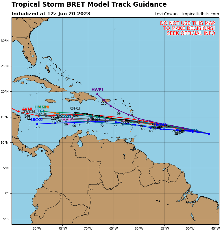
Tropical Cyclone 03L (Bret)…is located about 730 miles east of the southern Windward Islands
Tropical Cyclone 03L (Bret)
BRET STRENGTHENS A LITTLE MORE
According to the NHC advisory number 7
Bret is moving toward the west near 17 mph (28 km/h), and this general motion is expected to continue for the next several days. On the forecast track, the center of Bret is expected move across portions of the Lesser Antilles Thursday afternoon and Thursday night, and then move across the eastern Caribbean Sea on Friday.
Maximum sustained winds have increased to near 50 mph (85 km/h) with higher gusts. Some additional strengthening is forecast during the next day or so, and Bret is expected to be a tropical storm when it reaches the Lesser Antilles Thursday and Thursday night.
Tropical-storm-force winds extend outward up to 45 miles (75 km) from the center.
HAZARDS AFFECTING LAND
Wind: Tropical storm conditions are possible within the watch area by Thursday.
Rainfall:Through Saturday, storm total rainfall amounts of 3 to 6 inches with maximum amounts of 10 inches possible across portions of the Lesser Antilles from Guadeloupe south to St Vincent and the Grenadines, including Barbados. The heavy rainfall could lead to flash flooding, especially across areas of higher terrain. Isolated urban flooding is also possible.
Eastern Tropical Atlantic:
Invest 93L
Shower and thunderstorm activity has diminished during the past several hours in association with a tropical wave located several hundred miles southwest of the Cabo Verde Islands.
However, environmental conditions appear conducive for further development of this system, and a tropical depression will likely form during the next couple of days while the system moves westward at 10 to 15 mph across the eastern and central tropical Atlantic.
* Formation chance through 48 hours…high…70 percent
* Formation chance through 7 days…high…80 percent
