

")
Tropical Cyclone 06S (Anggrek) / Tropical Cyclone 07P / Invest 92S
Tuesday, January 23, 2024
Current Snapshot
For all the latest updates visit: DisasterAWARE
j

pdcang

06S_230600sair

himawari9_ir_06S_202401231520_lat-13.3-lon91.6

06S_tracks_latest

pdc07P

07P_231200sair

himawari9_ir_07P_202401231520_lat-17.3-lon153.5
07P_tracks_latest

pdc92s

meteosat9_ir_92S_202401231521_lat-19.6-lon58.8

92S_tracks_latest
By PDC’s Senior Weather
Specialist Glenn James

The Pacific Disaster Center’s (PDC Global) Tuesday, January 23, 2024, Tropical Cyclone Activity Report…for the Pacific Ocean, the Indian Ocean, and adjacent Seas
Current Tropical Cyclones:
Tropical Cyclone 06S (Anggrek)…is located approximately 1185 NM east-southeast of Diego Garcia
Tropical Cyclone 07P…is located approximately 414 NM east of Cairns, Australia
Northeast Pacific Ocean:
The North Pacific hurricane season officially ended on November 30, 2023. Routine issuance of the Tropical Weather Outlook will resume on May 15, 2024. During the off-season, Special Tropical Weather Outlooks will be issued as conditions warrant.
The eastern Pacific basin hurricane season was above normal, with 17 named storms, of which 10 were hurricanes and eight of those major hurricanes.
From August 16 to 21, Tropical Storm Hilary brought widespread heavy rainfall and flooding to Southern California, with some areas receiving up to 600% of their normal August rainfall. Hilary resulted in the first ever issuance of Tropical Storm Watches and Warnings for the Southern California coastline by NOAA’s National Hurricane Center. In addition, the Center distributed key hazard focused messages for Hilary in Spanish through the agency’s new language translation project.
Hurricane Otis made landfall near Acapulco, Mexico, on October 25 as a category-5 hurricane, with sustained winds of 165 mph. Otis holds the record as the strongest land falling hurricane in the eastern Pacific, after undergoing rapid intensification in which wind speeds increased by 115 mph in 24 hours.
Central North Pacific:
The central North Pacific hurricane season officially ended on November 30, 2023. Routine issuance of the Tropical Weather Outlook will resume on June 1, 2024. During the off-season, Special Tropical Weather Outlooks will be issued as conditions warrant.
The central Pacific basin had a near-normal season with four tropical systems traversing the basin.
Hurricane Dora, a category-4 storm, passed south of Hawaii in early August, marking the first major hurricane in the central Pacific basin since 2020. The strong gradient between a high pressure system to the north and Dora to the south was a contributing factor to the wind-driven, fast-moving wildfires in Hawaii.
Western Pacific, Indian Ocean and adjacent Seas:
South Indian Ocean…
Tropical Cyclone 06S (Anggrek)
According to the JTWC warning number 18, sustained winds are 35 knots…with gusts to near 45 knots.
Tropical cyclone 06S has maintained intensity at 40 knots due primarily to upwelling cooler water resulting from the system’s slow track motion as revealed in the recent sea surface temperature analysis
Animated enhanced infrared (eir) satellite imagery depicts fragmented, weak deep convective banding wrapping into a ragged low-level circulation center (llcc). A microwave image shows a 100-110 NM diameter convection free core with deep convective bands wrapped loosely. A bullseye image shows a defined center with 30-35 knot winds over the eastern semicircle. Animated water vapor imagery and recent upper-level winds show an upper-level trough impinging on the southern periphery of the system, limiting poleward outflow, with moderate equatorward outflow.
Track motion is expected to remain slow and possibly erratic until after 24 hours when a dominant str is forecast to build to the south and then southeast, which will accelerate the system west-southwestward through the forecast period. As the system accelerates, the limiting effects of the upwelling cooler water will lessen and the system will intensify at a faster rate up to a peak intensity of 70-75 knots.
After 72 hours,environmental conditions will degrade slightly with some dry air entrainment and weaker outflow resulting in a slight weakening trend.
Southwest Pacific Ocean…
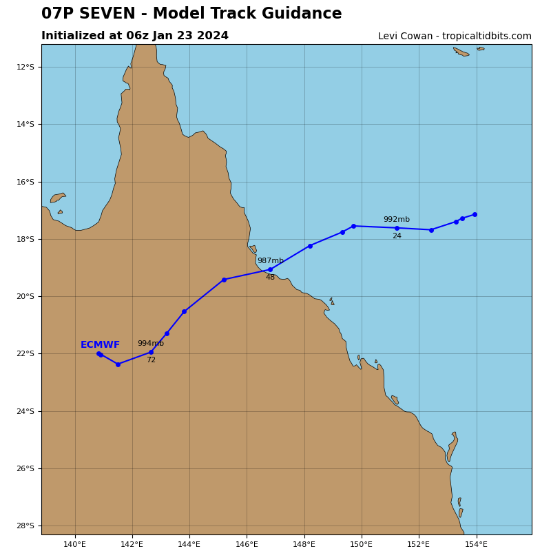
Tropical Cyclone 07P
According to the JTWC warning number 4, sustained winds are 40 knots…with gusts to near 50 knots.
A broad upper-level low remains entrenched over the system, hindering core convective development, with good poleward venting into a jet to the southeast helping sustain deep convection over the southern semicircle. Animated enhanced infrared satellite imagery reveals a broad, exposed low-level circulation (llc) with fragmented deep convective banding over the eastern quadrant and southern semicircle. A microwave image reveals a relatively unimpressive convective structure with shallow banding wrapping around a broad llc. A scatterometer pass also indicates a broad weak core with patchy gale-force winds displaced over the northern and southern quadrants.
TC 07P is tracking slowly along an extension of the str to the south and is forecast to turn westward to west-southwestward after 12 hours as the str to the south becomes the dominant steering influence through the forecast period.
Over the next day, the upper-level low is expected to gradually erode, replaced by upper-level ridging. This will allow the system to intensify at a faster rate to a peak intensity of 55 knots at landfall near 48 hours. After 48 hours, the system will rapidly weaken as it tracks inland, with dissipation anticipated by 72 hours.
>>> There’s an area of disturbed weather being referred to as Invest 92S…which is located approximately 23 NM east-northeast of Mauritius
Animated enhanced infrared satellite imagery and a microwave image depict shallow banding and a consolidating low-level circulation center (llcc), with the deep convection placed in the northern periphery. A recent ship observation to the east of 92S currently shows east-northeasterly winds at 18 knots and a drop of 2 millibars in the past 24 hours.
Environmental analysis indicates that 92S is in a marginally favorable environment for further development, with weak equatorward outflow aloft, low to moderate (15-20 knot) vertical wind shear, and warm sea surface temperatures.
Model guidance indicates that the system will continue to deepen and become more organized over the next 24 hours, passing close to Mauritius.
Maximum sustained surface winds are estimated at 25 to 30 knots.
The potential for the development of a significant tropical cyclone within the next 24 hours is upgraded to high.
