

")
Tropical Cyclone 06S (Anggrek) / Tropical Cyclone 07P (Kirrily) / Tropical Cyclone 08S (Candice)
Thursday, January 25, 2024
Current Snapshot
For all the latest updates visit: DisasterAWARE

10

pdcanggrek

06S_250600sair

meteosat9_ir_06S_202401251521_lat-15.5-lon89.2

06S_tracks_latest

pdccandice

08S_251200sair

meteosat9_ir_08S_202401251521_lat-23.6-lon60.4
08S_tracks_latest

pdckirrily

07P_251200sair

himawari9_ir_07P_202401251520_lat-19.3-lon146.1

07P_tracks_latest
By PDC’s Senior Weather
Specialist Glenn James

The Pacific Disaster Center’s (PDC Global) Thursday, January 25, 2024, Tropical Cyclone Activity Report…for the Pacific Ocean, the Indian Ocean, and adjacent Seas
Current Tropical Cyclones:
Tropical Cyclone 06S (Anggrek)…is located approximately 1064 NM southeast of Diego Garcia
Tropical Cyclone 08S (Candice)…is located approximately 381 NM south-southeast of Port Louis, Mauritius
Tropical Cyclone 07P (Kirrily)…is located approximately 145 NM south of Cairns, Australia – Final Warning
Northeast Pacific Ocean:
The North Pacific hurricane season officially ended on November 30, 2023. Routine issuance of the Tropical Weather Outlook will resume on May 15, 2024. During the off-season, Special Tropical Weather Outlooks will be issued as conditions warrant.
The eastern Pacific basin hurricane season was above normal, with 17 named storms, of which 10 were hurricanes and eight of those major hurricanes.
From August 16 to 21, Tropical Storm Hilary brought widespread heavy rainfall and flooding to Southern California, with some areas receiving up to 600% of their normal August rainfall. Hilary resulted in the first ever issuance of Tropical Storm Watches and Warnings for the Southern California coastline by NOAA’s National Hurricane Center. In addition, the Center distributed key hazard focused messages for Hilary in Spanish through the agency’s new language translation project.
Hurricane Otis made landfall near Acapulco, Mexico, on October 25 as a category-5 hurricane, with sustained winds of 165 mph. Otis holds the record as the strongest land falling hurricane in the eastern Pacific, after undergoing rapid intensification in which wind speeds increased by 115 mph in 24 hours.
Central North Pacific:
The central North Pacific hurricane season officially ended on November 30, 2023. Routine issuance of the Tropical Weather Outlook will resume on June 1, 2024. During the off-season, Special Tropical Weather Outlooks will be issued as conditions warrant.
The central Pacific basin had a near-normal season with four tropical systems traversing the basin.
Hurricane Dora, a category-4 storm, passed south of Hawaii in early August, marking the first major hurricane in the central Pacific basin since 2020. The strong gradient between a high pressure system to the north and Dora to the south was a contributing factor to the wind-driven, fast-moving wildfires in Hawaii.
Western Pacific, Indian Ocean and adjacent Seas:
South Indian Ocean…
Tropical Cyclone 06S (Anggrek)
According to the JTWC warning number 22, sustained winds are 90 knots…with gusts to near 110 knots.
The system appears to be intensifying in a region of low shear (5-10 knot) and favorable sea surface temperatures. The steering environment is driving the storm to the southwest along the northwestern side of a subtropical ridge (str) south that appears to be building to the southeast. The
initial position was determined via a microwave image depicting modest convective banding features wrapping into a low level circulation center (llcc).
Tropical cyclone 06S (Anggrek) is forecast to continue on a southwestward track through 36 hours, before turning onto a more west-southwestward track through 72 hours. From 72 hours through the end of the forecast period, the system is expected to curve to the south-southwest as it rounds the str axis.
The intensity of TC 06S is expected to increase steadily to 105 knots through 72 hours as wind shear is expected to remain low (5-10 knots), and sea surface temperatures will be favorable, and upper-level outflow conditions improve slightly. After 96 hours, the system will begin to weaken as shear picks up slightly (10-15 knots) and dry mid-level air intrudes from the north and west.
By 120 hours, TC 06S is anticipated to have a more rapid drop in intensity as shear is expected to increase significantly to approximately 20 knots and decapitate the storm’s vortex at the mid-levels. Coupled with dry air entrainment, the storm is forecast to decrease to 80 knots by the end of the forecast period.
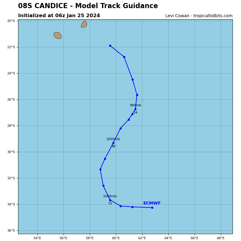
Tropical Cyclone 08S (Candice)
According to the JTWC warning number 3, sustained winds are 45 knots…with gusts to near 55 knots.
Animated multi-spectral satellite imagery (msi) depicts tropical cyclone 08S (Ccandice) tracking south-southeastward at 19 knots. A low level circulation center (llcc) is clearly visible with minimal outflow and small amounts of deep layer convection sprouting in the western portion of the cyclone.
There is marginal vertical wind shear (10-15 knots) and marginally favorable sea surface temperatures. The primary steering mechanism for the system is a subtropical ridge to the east with an enhanced gradient induced by a sharp trough approaching from the west.
TC 08S (Candice) is forecast to track to the south-southeast through 24 hours on the northwestern periphery of a str to the east before tracking on a southwestern course from 48-72 hours as the ridge expands and builds in to the south of the system. As the system weakens and the vortex becomes shallow, the llcc embeds under a mid-level trough and becomes quasi-stationary after 72 hours.
The system is forecast to intensify slightly over the 12 hours, peaking at 55 knots before beginning its decline at 24 hours. Elevated vertical wind shear of 15-25 knots, dry air entrainment from the north, and rapidly decreasing sea surface temperatures are expected to cause TC 08S to weaken quickly.
It will be a race to determine whether TCc 08S will dissipate or transition into a subtropical system, but at this time it is expected that the system will begin dissipating over water at 72 hours and fully dissipate to 30 knots no later than 96 hours.
Southwest Pacific Ocean…
Tropical Cyclone 07P (Kirrily) – Final Warning
According to the JTWC warning number 11, sustained winds are 50 knots…with gusts to near 65 knots.
Animated enhanced infrared satellite imagery and a composite radar loop from Greenvale, Australia has shown that tropical cyclone 07P made landfall around 1200z just northwest of Townsville, Australia.
TC 07P will continue to track west-southwestward and further inland under the steering influence of a subtropical ridge (str) to the southeast. Interaction with terrain, dry air entrainment, and moderate wind shear will enhance the unfavorable environment and the system will fully dissipate by 24 hours. Remnants of TC 07P will continue across the northern portion of Australia towards the western coast beyond 24 hours.
