

")
Tropical Cyclone 06S (Anggrek) / Invest 93S
Monday, January 29, 2024
Current Snapshot
For all the latest updates visit: DisasterAWARE

11

pdcang

06S_290600sair

meteosat9_ir_06S_202401291521_lat-25.1-lon70.8

06S_tracks_latest
pdc93s

meteosat9_ir_93S_202401292251_lat-17.0-lon64.4
93S_tracks_latest
By PDC’s Senior Weather
Specialist Glenn James

The Pacific Disaster Center’s (PDC Global) Monday, January 29, 2024, Tropical Cyclone Activity Report…for the Pacific Ocean, the Indian Ocean, and adjacent Seas
Current Tropical Cyclones:
Tropical Cyclone 06S (Anggrek)…is located approximately 832 NM east-southeast of Port Louis, Mauritius
Northeast Pacific Ocean:
The North Pacific hurricane season officially ended on November 30, 2023. Routine issuance of the Tropical Weather Outlook will resume on May 15, 2024. During the off-season, Special Tropical Weather Outlooks will be issued as conditions warrant.
The eastern Pacific basin hurricane season was above normal, with 17 named storms, of which 10 were hurricanes and eight of those major hurricanes.
From August 16 to 21, Tropical Storm Hilary brought widespread heavy rainfall and flooding to Southern California, with some areas receiving up to 600% of their normal August rainfall. Hilary resulted in the first ever issuance of Tropical Storm Watches and Warnings for the Southern California coastline by NOAA’s National Hurricane Center. In addition, the Center distributed key hazard focused messages for Hilary in Spanish through the agency’s new language translation project.
Hurricane Otis made landfall near Acapulco, Mexico, on October 25 as a category-5 hurricane, with sustained winds of 165 mph. Otis holds the record as the strongest land falling hurricane in the eastern Pacific, after undergoing rapid intensification in which wind speeds increased by 115 mph in 24 hours.
Central North Pacific:
The central North Pacific hurricane season officially ended on November 30, 2023. Routine issuance of the Tropical Weather Outlook will resume on June 1, 2024. During the off-season, Special Tropical Weather Outlooks will be issued as conditions warrant.
The central Pacific basin had a near-normal season with four tropical systems traversing the basin.
Hurricane Dora, a category-4 storm, passed south of Hawaii in early August, marking the first major hurricane in the central Pacific basin since 2020. The strong gradient between a high pressure system to the north and Dora to the south was a contributing factor to the wind-driven, fast-moving wildfires in Hawaii.
Western Pacific, Indian Ocean and adjacent Seas:
South Indian Ocean…
Tropical Cyclone 06S (Anggrek)
According to the JTWC warning number 30, sustained winds are 105 knots…with gusts to near 130 knots.
Animated multi-spectral satellite imagery shows a compact system that has become more elongated and asymmetrical with initial exposure to the prevailing westerlies. Transverse banding is evident along the southern peripheries to indicate strong outflow and imminent high vertical wind shear. Enhanced IR imagery shows the central dense overcast remains deep but have now begun to warm while maintaining a defined 10 NM eye.
The initial intensity is estimated to be 102 knots, which is consistent with the gradual 12 hours convective deterioration. Analysis indicates a favorable environment with low vertical wind shear, warm sea surface temperatures, and strong poleward
outflow.
TC Anggrek will turn more poleward as it rounds the ridge axis, recurve and accelerate southeastward as the ridge recedes in response to an approaching mid-latitude from the west.
The environment will quickly become unfavorable with increasing vertical wind shear associated with the strong westerlies, then the addition of cooling sea surface temperatures and dry air intrusion will gradually erode the system.
Concurrently, by 36 hours, TC 08S will begin extra-tropical transition, and by 120 hours, will transform into a storm-force cold core low with an expanding wind field.
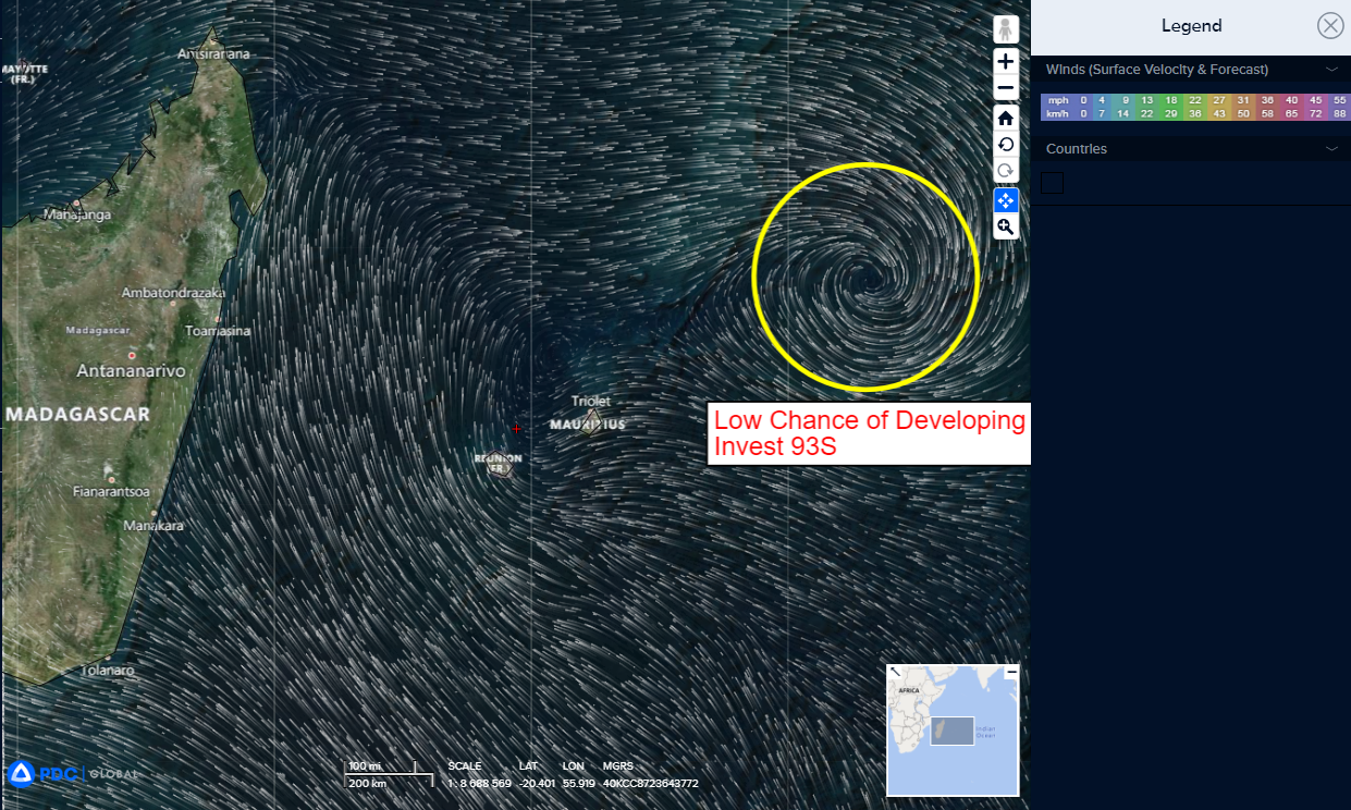
South Indian Ocean…
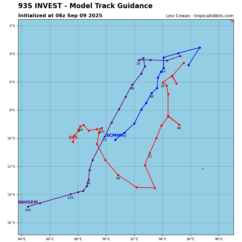
An area of disturbed weather, being referred to as Invest 93S, is now under investigation by the JTWC…it’s located approximately 436 NM east-northeast of Mauritius.
Enhanced infrared satellite imagery and a microwave satellite image depicts an area of flaring convection and a consolidating low level circulation center.
Upper level analysis depicts a marginally favorable environment for development with weak poleward divergence aloft, offset by low to moderate vertical wind shear (15-20 knots) and moderate sea surface temperatures.
Global deterministic models are in good agreement that 93S will generally track southeastward and intensify as it tracks towards a relatively favorable environment for cyclogenesis.
Maximum sustained surface winds are estimated at 17 to 22 knots.
The potential for the development of a significant tropical cyclone within the next 24 hours is low.
