

")
Tropical Cyclone 05S / Invest 98S
Friday, January 12, 2024
Current Snapshot
For all the latest updates visit: DisasterAWARE
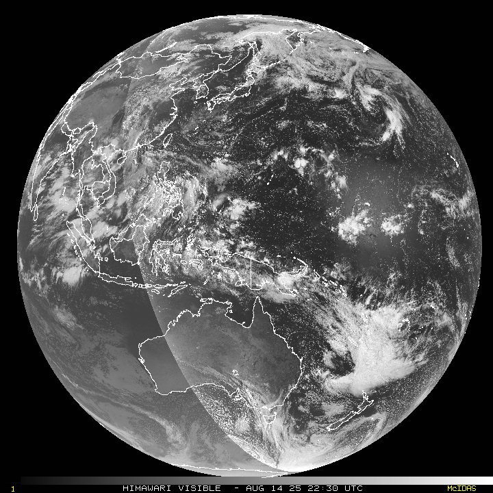
10

pdc05S

jtwc

meteosat9_ir_05S_202401121536_lat-13.3-lon56.6
05S_tracks_latest

pdc98s

himawari9_ir_98S_202401121550_lat-10.0-lon93.1

98S_tracks_latest
By PDC’s Senior Weather
Specialist Glenn James

The Pacific Disaster Center’s (PDC Global) Friday, January 12, 2024, Tropical Cyclone Activity Report…for the Pacific Ocean, the Indian Ocean, and adjacent Seas
Current Tropical Cyclones:
Tropical Cyclone 05S…is located approximately 410 NM north of Port Louis, Mauritius
Northeast Pacific Ocean:
The North Pacific hurricane season officially ended on November 30, 2023. Routine issuance of the Tropical Weather Outlook will resume on May 15, 2024. During the off-season, Special Tropical Weather Outlooks will be issued as conditions warrant.
The eastern Pacific basin hurricane season was above normal, with 17 named storms, of which 10 were hurricanes and eight of those major hurricanes.
From August 16 to 21, Tropical Storm Hilary brought widespread heavy rainfall and flooding to Southern California, with some areas receiving up to 600% of their normal August rainfall. Hilary resulted in the first ever issuance of Tropical Storm Watches and Warnings for the Southern California coastline by NOAA’s National Hurricane Center. In addition, the Center distributed key hazard focused messages for Hilary in Spanish through the agency’s new language translation project.
Hurricane Otis made landfall near Acapulco, Mexico, on October 25 as a category-5 hurricane, with sustained winds of 165 mph. Otis holds the record as the strongest land falling hurricane in the eastern Pacific, after undergoing rapid intensification in which wind speeds increased by 115 mph in 24 hours.
Central North Pacific:
The central North Pacific hurricane season officially ended on November 30, 2023. Routine issuance of the Tropical Weather Outlook will resume on June 1, 2024. During the off-season, Special Tropical Weather Outlooks will be issued as conditions warrant.
The central Pacific basin had a near-normal season with four tropical systems traversing the basin.
Hurricane Dora, a category-4 storm, passed south of Hawaii in early August, marking the first major hurricane in the central Pacific basin since 2020. The strong gradient between a high pressure system to the north and Dora to the south was a contributing factor to the wind-driven, fast-moving wildfires in Hawaii.
Western Pacific, Indian Ocean and adjacent Seas:
South Indian Ocean…
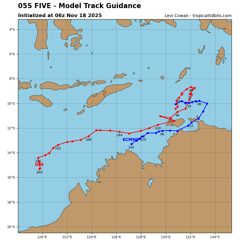
Tropical Cyclone 05S
According to the JTWC warning number 1, sustained winds are 35 knots…with gusts to near 45 knots.
Animated multi=spectral satellite imagery depicts a rapidly consolidating and intensifying system, with well-defined spiral bands wrapping into an increasingly defined low level circulation center (llcc). While cloud top temperatures have warmed over the past three hours, deep convective towers continue to fire on the northern side of the center but are struggling to wrap upshear. A microwave image depicts a small, well-defined inner core of moderate convection, with strong inflow bands to the west-southwest and northern sides of the llcc defining the circulation center.
Analysis reveals a very favorable environment characterized by low (0-5 knots) of easterly shear, dual-channel outflow aloft, zesty sea surface temperatures. The system is moving to the southwest along the western side of a subtropical ridge (str) centered to the east.
Tropical cyclone 05S is forecast to track generally towards the southwest along the west side of the steering ridge for the next 36 hours. Track speeds will remain relatively steady through the first day or so of the forecast as the ridge remains entrenched to the east. By 36 hours, the track begins to turn more southward and slows down as the ridge begins to reorient to a more northwest-southeast axis.
Shortly after 48 hours, TC 05S will be firmly set upon a southeastward track as the ridge completes its reorientation phase, and is expected to pass between La Reunion and Mauritius around 96 hours, then continue into the open waters of the Southern Indian Ocean.
In terms of intensity, the environment is optimum for rapid intensification once the llcc fully consolidates, which is expected imminently. Optimum conditions are forecast to continue for the next 48 hours, allowing the system to intensify at least 60 knots over the next two days.
Conditions remain favorable for another 24 hours after that, and additional intensification up to at least 105 knots, and potential higher, is expected prior to the system reaching the Mascarene Archipelago. A rapid decrease in ocean heat content and sea surface temperatures, accompanied by a sharp increase in shear will induce a slow but steady weakening trend after 96 hours as the system continues moving poleward.
There’s an area of disturbed weather, being referred to as Invest 98S…located approximately 297 NM west-northwest of the Cocos Islands.
Enhanced infrared satellite imagery and a microwave image depict weak convection to the southwestern and northeastern quadrants, wrapping into a poorly defined low level circulation center (llcc), with associated weak mid-level turning.
Environmental analysis indicates a marginally favorable environment for development due to low (10-15 knot) vertical wind shear, warm sea surface temperatures, offset by weak equatorward outflow.
Global models agree that 98S will generally remain quasi-stationary.
Maximum sustained surface winds are estimated at 18 to 22 knots.
The potential for the development of a significant tropical cyclone within the next 24 hours remains low.
