

")
Tropical Cyclone 05S (Belal) / Tropical Cyclone 06S (Anggrek) / Invest 90P
Wednesday, January 17, 2024
Current Snapshot
For all the latest updates visit: DisasterAWARE
10

pdcbelal

05S_171200sair

meteosat9_ir_05S_202401171536_lat-24.2-lon63.6
05S_tracks_latest

pdcang

06S_170600sair

himawari9_ir_06S_202401171540_lat-10.4-lon94.0
06S_tracks_latest

pdc90P

himawari9_ir_90P_202401171540_lat-15.0-lon153.0

90P_tracks_latest
By PDC’s Senior Weather
Specialist Glenn James

The Pacific Disaster Center’s (PDC Global) Wednesday, January 17, 2024, Tropical Cyclone Activity Report…for the Pacific Ocean, the Indian Ocean, and adjacent Seas
Current Tropical Cyclones:
Tropical Cyclone 05S (Belal)…is located approximately 483 NM east-southeast of Port Louis, Muritius
Tropical Cyclone 06S (Anggrek)…is located approximately 1200 NM northeast of the Kingston
Northeast Pacific Ocean:
The North Pacific hurricane season officially ended on November 30, 2023. Routine issuance of the Tropical Weather Outlook will resume on May 15, 2024. During the off-season, Special Tropical Weather Outlooks will be issued as conditions warrant.
The eastern Pacific basin hurricane season was above normal, with 17 named storms, of which 10 were hurricanes and eight of those major hurricanes.
From August 16 to 21, Tropical Storm Hilary brought widespread heavy rainfall and flooding to Southern California, with some areas receiving up to 600% of their normal August rainfall. Hilary resulted in the first ever issuance of Tropical Storm Watches and Warnings for the Southern California coastline by NOAA’s National Hurricane Center. In addition, the Center distributed key hazard focused messages for Hilary in Spanish through the agency’s new language translation project.
Hurricane Otis made landfall near Acapulco, Mexico, on October 25 as a category-5 hurricane, with sustained winds of 165 mph. Otis holds the record as the strongest land falling hurricane in the eastern Pacific, after undergoing rapid intensification in which wind speeds increased by 115 mph in 24 hours.
Central North Pacific:
The central North Pacific hurricane season officially ended on November 30, 2023. Routine issuance of the Tropical Weather Outlook will resume on June 1, 2024. During the off-season, Special Tropical Weather Outlooks will be issued as conditions warrant.
The central Pacific basin had a near-normal season with four tropical systems traversing the basin.
Hurricane Dora, a category-4 storm, passed south of Hawaii in early August, marking the first major hurricane in the central Pacific basin since 2020. The strong gradient between a high pressure system to the north and Dora to the south was a contributing factor to the wind-driven, fast-moving wildfires in Hawaii.
Western Pacific, Indian Ocean and adjacent Seas:
South Indian Ocean…
Tropical Cyclone 05S (Belal)
According to the JTWC warning number 12, sustained winds are 45 knots…with gusts to near 55 knots.
Animated multi-spectral satellite imagery depicts TC 05S (Belal) with a minimally obstructed view of the low-level circulation center (llcc) and a dislocated upper-level outflow to the southeast of the storm. The storm continues to creep eastward as it begins to interact with a ridge to the northeast.
Powerful west-northwesterly wind shear (25-30 knots) along with dry air entraining into the system from the west will continue to force the storm to lose steam through the remainder of the forecast period despite favorable sea surface temperatures.
TC 05S (Belal) is anticipated to continue to creep eastward along the southern side of the ridge to the north for the next 12 hours, but then comes to a stop and becomes quasi-stationary as it runs into a building ridge to the east. Following 24 hours, as the system rapidly weakens, the steering level progressively lowers, resulting in a sharp turn back to the west then southwest, along the northern side a low- to mid-level mid-latitude anticyclone centered to the south.
Through the forecast period, the storm will continue to lose intensity as strong wind shear from the east (25-30 knots) will tear apart the vortex structure, limiting the system’s capability to re-intensify. TC 05S will be further weakened by dry air moving in from the west, which will fully engulf the remnant circulation. Ultimately the combination of dry air and persistent shear will lead to dissipation by 48 hours.
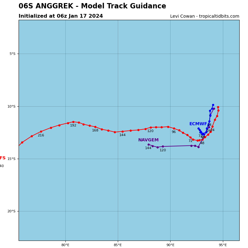
Tropical Cyclone 06S (Anggrek)
According to the JTWC warning number 6, sustained winds are 45 knots…with gusts to near 55 knots.
Animated multi-spectral satellite imagery shows tropical cyclone 06S (Anggrek) has a partially obscured low level circulation center (llcc) with minimal convective outflow aloft drifting to the southwest, revealing a vertical tilt to the southwest with height. Asymmetrical swaths of deep convection to the northwest of the system highlights banding wrapping into the circulation.
Despite the disorganized upper-level outflow, the lower levels expose a tight circulation of cloud bands. Deep layer shear is low at 10-15 knots, but mid-level shear appears to be cutting off the system with the GFS model sounding showing 15-20 knot east-northeast shear. The environment is marginally favorable as sea surface temperatures and overall shear remains low. The primary mitigating factor at the moment is the dry air firmly ensconced to the west.
TC 06S (Anggrek) is expected to continue tracking south riding the edge of a strong ridge to the east through 12 hours. Between 12-24 hours, the ridge to the east will build and extend with a strong gradient to the south of the storm, steering the system to the south-southwest through 48 hours. By 72 hours, the storm is expected to turn due west as a result of being blocked to the north by the near equatorial ridge (ner), to the east by a trough, and to the south by a ridge.
System intensity is anticipated to continue to increase through 36 hours due to favorable sea surface temperatures, low deep layer wind shear, modest relative humidity levels, and slightly improved upper-level outflow. The primary mitigating factor preventing the system from continuing to
intensify beyond 36 hours is the dry air that is anticipated to wrap into the system from the west and continue through the forecast
period.
Mid level vertical shear is anticipated to persist in the 15-20 knot range throughout the entire forecast period, but in the early phase of the forecast, the shear will be offset by the other favorable parameters, allowing for a short period of intensification. In the longer-term, the combined impact of the dry air and mid-level wind shear will lead to a slow but steady weakening through the end of the forecast period.
>>> There’s an area of disturbed weather being referred to as Invest 90P…which is located approximately 459 NM east of Cairns, Australia.
Animated multi-spectral satellite imagery depicts a broad low level circulation (llc) with flaring convection in the northern periphery of
the system, that slightly obscures the low level circulation center (llcc).
The environment is favorable for development with low (5-10 knot) vertical wind shear, warm sea surface temperature values, and good equatorward outflow aloft. The primary hindrance for invest 90P is the significant mid-level shear from the upper level trough to the southeast, which is preventing convection from wrapping into the system and keeping the vortex confined to the lower levels. The slow organization of circulation is also evident on recent total precipitable water animation.
Global models are in agreement that invest 90P will continue on an eastward track with steady intensification over the next 24 hours while moving into an even more favorable environment as the trough continues on and mid-level shear from the south decreases.
Maximum sustained surface winds are estimated at 17 to 22 knots.
The potential for the development of a significant tropical cyclone within the next 24 hours is low.
