

")
Tropical Cyclone 05S (Belal) / Tropical Cyclone 06S (Anggrek) / Invest 90P
Thursday, January 18, 2024
Current Snapshot
For all the latest updates visit: DisasterAWARE

10

pdcbelal
05S_181200sair

meteosat9_ir_05S_202401181506_lat-23.9-lon65.6

05S_tracks_latest

pdcanggrek

06S_180600sair

himawari9_ir_06S_202401181510_lat-12.0-lon93.7

06S_tracks_latest

pdc90P

himawari9_ir_90P_202401181510_lat-14.2-lon155.6

90P_tracks_latest
By PDC’s Senior Weather
Specialist Glenn James

The Pacific Disaster Center’s (PDC Global) Thursday, January 18, 2024, Tropical Cyclone Activity Report…for the Pacific Ocean, the Indian Ocean, and adjacent Seas
Current Tropical Cyclones:
Tropical Cyclone 05S (Belal)…is located approximately 515 NM east-southeast of Port Louis, Mauritius
Tropical Cyclone 06S (Anggrek)…is located approximately 1261 NM east-southeast of Diego Garcia
Northeast Pacific Ocean:
The North Pacific hurricane season officially ended on November 30, 2023. Routine issuance of the Tropical Weather Outlook will resume on May 15, 2024. During the off-season, Special Tropical Weather Outlooks will be issued as conditions warrant.
The eastern Pacific basin hurricane season was above normal, with 17 named storms, of which 10 were hurricanes and eight of those major hurricanes.
From August 16 to 21, Tropical Storm Hilary brought widespread heavy rainfall and flooding to Southern California, with some areas receiving up to 600% of their normal August rainfall. Hilary resulted in the first ever issuance of Tropical Storm Watches and Warnings for the Southern California coastline by NOAA’s National Hurricane Center. In addition, the Center distributed key hazard focused messages for Hilary in Spanish through the agency’s new language translation project.
Hurricane Otis made landfall near Acapulco, Mexico, on October 25 as a category-5 hurricane, with sustained winds of 165 mph. Otis holds the record as the strongest land falling hurricane in the eastern Pacific, after undergoing rapid intensification in which wind speeds increased by 115 mph in 24 hours.
Central North Pacific:
The central North Pacific hurricane season officially ended on November 30, 2023. Routine issuance of the Tropical Weather Outlook will resume on June 1, 2024. During the off-season, Special Tropical Weather Outlooks will be issued as conditions warrant.
The central Pacific basin had a near-normal season with four tropical systems traversing the basin.
Hurricane Dora, a category-4 storm, passed south of Hawaii in early August, marking the first major hurricane in the central Pacific basin since 2020. The strong gradient between a high pressure system to the north and Dora to the south was a contributing factor to the wind-driven, fast-moving wildfires in Hawaii.
Western Pacific, Indian Ocean and adjacent Seas:
South Indian Ocean…
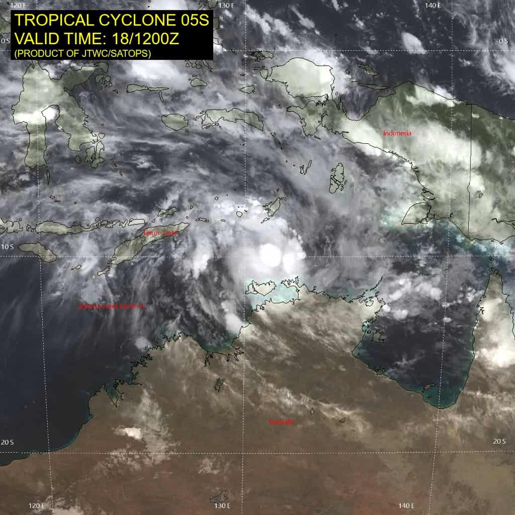
Tropical Cyclone 05S (Belal)
According to the JTWC warning number 13, sustained winds are 45 knots…with gusts to near 55 knots.
Animated multi-spectral satellite imagery depicts a broad, partially-exposed low-level circulation with deep convective banding over the northern semicircle. A partial microwave image shows the bulk of the deep convection confined to the northern semicircle with a weakly-defined center on the southern edge of the convective band. The relative humidity product indicates dry air entrainment is currently occurring over the southern semicircle.
Tropical cyclone 06S is drifting slowly southward within the competing steering environment, along an extension of the steering ridge to the east. However, the system is expected to turn westward within the next 24 to 36 hours as it transitions to the steering influence of the weak ridge positioned to the south.
After 48 hours, TC 06s will track slowly west-northwestward along the northeastern periphery of the low- to mid-level ridge. TC 06S should intensify to a peak intensity of 55 knots within the next day, due to the favorable outflow, hindered slightly by the presence of dry air. The system will maintain intensity near 50 knots from 24 to 72 hours, then finally succumb to significant dry air entrainment.
Tropical Cyclone 06S (Anggrek)
According to the JTWC warning number 8, sustained winds are 45 knots…with gusts to near 55 knots.
Animated multi-spectral satellite imagery depicts a broad, partially-exposed low-level circulation with deep convective banding over the northern semicircle. A microwave image shows the bulk of the deep convection confined to the northern semicircle with a weakly-defined center on the southern edge of the convective band. The relative humidity product indicates dry air entrainment is currently occurring over the southern semicircle.
Tropical cyclone 06S is drifting slowly southward within the competing steering environment, along an extension of the steering ridge to the east. However, the system is expected to turn westward within the next 24 to 36 hours as it transitions to the steering influence of the weak ridge positioned to the south.
After 48 hours, TC 06S will track slowly west-northwestward along the northeastern periphery of the low- to mid-level ridge. TC 06S should intensify to a peak intensity of 55 knots within the next day, due to the favorable outflow, hindered slightly by the presence of dry air. The system will maintain intensity near 50 knots from 24 to 72 hours, then finally succumb to significant dry air entrainment.
>>> There’s an area of disturbed weather being referred to as Invest 90P…which is located approximately 548 NM east-northeast of Cairns, Australia.
Animated multi-spectral satellite imagery depicts a fully exposed low-level circulation center with deep flaring convection in the northern semicircle.
Environmental analysis indicates that 90P is in a marginally unfavorable environment for development with weak outflow aloft, low to moderate (15-20 knot) vertical wind shear, and dry air entrainment.
Global models are in agreement that 90P will track northeast over the next 48 hours as it steadily develops.
Maximum sustained surface winds are estimated at 15 to 20 knots.
The potential for the development of a significant tropical cyclone within the next 24 hours remains low.
