

")
Tropical Cyclone 18W (Jelawat) / Invest 92W
Monday, December 18, 2023
Current Snapshot
For all the latest updates visit: DisasterAWARE
10

lpdcjelawat

jtwcjelawat

tsatjel
18W_tracks_latest

pdc92w

himawari9_ir_92W_202312181520_lat4.1-lon168.0
92W_tracks_latest
By PDC’s Senior Weather
Specialist Glenn James

The Pacific Disaster Center’s (PDC Global) Monday, December 18, 2023, Tropical Cyclone Activity Report…for the Pacific Ocean, the Indian Ocean, and adjacent Seas
Current Tropical Cyclones:
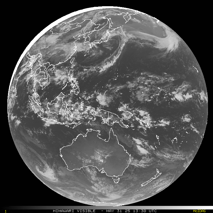
Tropical Storm 18W (Jelawat)…is located approximately 18 NM east-northeast of Davao City, Philippines – Final Warning
Northeast Pacific Ocean:
The North Pacific hurricane season officially ended on November 30, 2023. Routine issuance of the Tropical Weather Outlook will resume on May 15, 2024. During the off-season, Special Tropical Weather Outlooks will be issued as conditions warrant.
The eastern Pacific basin hurricane season was above normal, with 17 named storms, of which 10 were hurricanes and eight of those major hurricanes.
From August 16 to 21, Tropical Storm Hilary brought widespread heavy rainfall and flooding to Southern California, with some areas receiving up to 600% of their normal August rainfall. Hilary resulted in the first ever issuance of Tropical Storm Watches and Warnings for the Southern California coastline by NOAA’s National Hurricane Center. In addition, the Center distributed key hazard focused messages for Hilary in Spanish through the agency’s new language translation project.
Hurricane Otis made landfall near Acapulco, Mexico, on October 25 as a category-5 hurricane, with sustained winds of 165 mph. Otis holds the record as the strongest landfalling hurricane in the eastern Pacific, after undergoing rapid intensification in which wind speeds increased by 115 mph in 24 hours.
Central North Pacific:
The central North Pacific hurricane season officially ended on November 30, 2023. Routine issuance of the Tropical Weather Outlook will resume on June 1, 2024. During the off-season, Special Tropical Weather Outlooks will be issued as conditions warrant.
The central Pacific basin had a near-normal season with four tropical systems traversing the basin.
Hurricane Dora, a category-4 storm, passed south of Hawaii in early August, marking the first major hurricane in the central Pacific basin since 2020. The strong gradient between a high pressure system to the north and Dora to the south was a contributing factor to the wind-driven, fast-moving wildfires in Hawaii.
Western Pacific, Indian Ocean and adjacent Seas:
Northwest Pacific Ocean…
Tropical Depression 18W (Jelawat) – Final Warning
According to the JTWC Warning number 7, sustained winds are 25 knots…with gusts to 35 knots.
TD 18W continues to decay rapidly as the associated convective activity progressively becomes more fragmented and dispersed to the north and south of the ill-defined low level circulation.
TD Jelawat will continue to track westward under the steering influence of the subtropical ridge to the north and dissipate by 12 hours, likely sooner, due to continued interaction with the rugged and increased vertical wind shear.
~~~ An area of disturbed weather, being referred to as Invest 92W, is under investigation by the JTWC…which is located approximately 292 NM east-southeast of Kosrae.
Animated multi-spectral satellite imagery and a microwave image depict deep convective lines on the equatorward side of an elongated southwest to northeast orientated trough.
Environmental analysis reveals marginally favorable conditions for intensification due to low to moderate (15-20 knot) vertical wind shear and fair dual-channel outflow, offset by warm sea surface temperatures.
Numerical models show a mixed picture between good development and meandering motion, but agree on a generally westward trajectory.
Maximum sustained surface winds are estimated at 13 to 17 knots.
The potential for the development of a significant tropical cyclone within the next 24 hours remains low.
