

")
Tropical Cyclone 08B / Invest 92P
Saturday, December 2, 2023
Current Snapshot
For all the latest updates visit: DisasterAWARE
10

pdc92P
92P_tracks_latest
By PDC’s Senior Weather
Specialist Glenn James

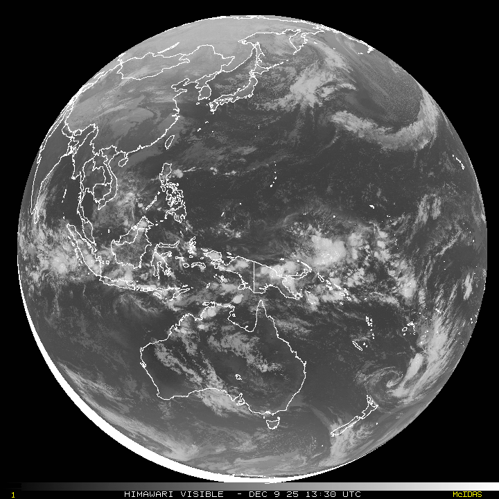
The Pacific Disaster Center’s (PDC Global) Saturday, December 2, 2023, Tropical Cyclone Activity Report…for the Pacific Ocean, the Indian Ocean, and adjacent Seas
Current Tropical Cyclones:
Tropical cyclone 08B…is located approximately 162 NM southeast of Chennai, India
Northeast Pacific Ocean:
The North Pacific hurricane season officially ended on November 30, 2023. Routine issuance of the Tropical Weather Outlook will resume on May 15, 2024. During the off-season, Special Tropical Weather Outlooks will be issued as conditions warrant.
The eastern Pacific basin hurricane season was above normal, with 17 named storms, of which 10 were hurricanes and eight of those major hurricanes.
From August 16 to 21, Tropical Storm Hilary brought widespread heavy rainfall and flooding to Southern California, with some areas receiving up to 600% of their normal August rainfall. Hilary resulted in the first ever issuance of Tropical Storm Watches and Warnings for the Southern California coastline by NOAA’s National Hurricane Center. In addition, the Center distributed key hazard focused messages for Hilary in Spanish through the agency’s new language translation project.
Hurricane Otis made landfall near Acapulco, Mexico, on October 25 as a category-5 hurricane, with sustained winds of 165 mph. Otis holds the record as the strongest landfalling hurricane in the eastern Pacific, after undergoing rapid intensification in which wind speeds increased by 115 mph in 24 hours.
Central North Pacific:
The central North Pacific hurricane season officially ended on November 30, 2023. Routine issuance of the Tropical Weather Outlook will resume on June 1, 2024. During the off-season, Special Tropical Weather Outlooks will be issued as conditions warrant.
The central Pacific basin had a near-normal season with four tropical systems traversing the basin.
Hurricane Dora, a category-4 storm, passed south of Hawaii in early August, marking the first major hurricane in the central Pacific basin since 2020. The strong gradient between a high pressure system to the north and Dora to the south was a contributing factor to the wind-driven, fast-moving wildfires in Hawaii.
Western Pacific, Indian Ocean and adjacent Seas:
North Indian Ocean
Tropical cyclone 08B
TC 08W has gathered itself and consolidated upstream of the southeast coast of India. The system developed slowly over the past few days. Over the past four hours convection deepened and tightened around the low levelcirculation center (llcc), leaving a broad doughnut hole that lends confidence to the position.
The intensity assessment is based on dvoraks and inferred from surface
pressure reports along the east coast of India as well as model fields. TC 08B is in an excellent environment for deepening. Animated water vapor imagery shows spectacular outflow, with the poleward flank tapping into a vigorous subtropical jet that is arching over Myanmar and southern China. Equatorward outflow is also vigorous.
Total precipitable water loops show deep moisture is now wrapping around the entire circulation as well as a broad belt of equatorial westerlies continuing to feed moisture into the system. The environment between the storm and the coast is completely saturated with deep moisture. Decent ocean heat content values lie along track underneath low vertical wind shear values. Wind shear increases sharply north of Chennai, but in the near term, even though the shear increases north of the 13th latitude, the enhanced exhaust will allow the system to develop further.
Tropical cyclone 08B will take a steady bend to the north-northwest, skirting the Pondicherry coast while deepening thanks to a very favorable environment. The system will intensify freely up until land interaction begins to wear on it near the coast. The parallel bearing to the coast and the larger than average track guidance spread make for lower certainty as to precisely where, and at what intensity, the system will come ashore.
But high tropical storm strength winds approaching typhoon strength just prior to landfall are plausible. Once inland, the system will begin rapid decay, but the risk of re-emergence over the northern Bay of Bengal remains possible. Even if TC o8B does track back into the northern Bay of Bengal, however, cooler sea water and very high vertical wind shear will cap intensification making re-intensification unlikely. The much more likely scenario is that of the system moving ashore near Ongole, and dissipating over land as it shears and chokes on dry mid-level air.
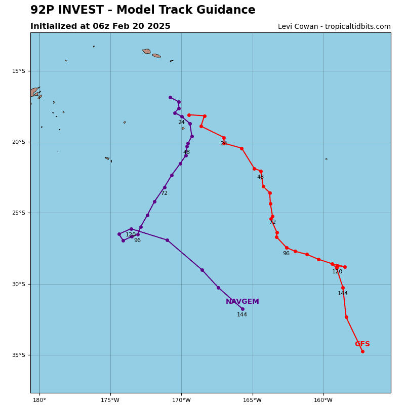
Southwest Pacific Ocean…
An area of disturbed weather, being referred to as Invest 92P…located approximately 476 NM east of Honiara, Guadalcanal, is under investigation by the Joint Typhoon Warning Center (JTWC).
Animated multi-spectral satellite imagery and a microwave image depict a broad and weakly defined low-level circulation, with scattered deep convection along the northern periphery.
Environmental analysis indicates that 92P is in a favorable environment for development with robust outflow aloft, low (5-10 knot) vertical wind shear, and warm sea surface temperatures.
Global models are in good agreement that 92P will track westward toward the Solomon Islands and continue to develop over the next 48 hours, before making a poleward turn at around 96 hours. .
Maximum sustained surface winds are estimated at 20 to 25 knots.
The potential for the development of a significant tropical cyclone within the next 24 hours is medium.
North Indian Ocean…
An area of disturbed weather, being referred to as Invest 95B…located approximately 218 NM east-southeast of Chennai, India, is under investigation by the Joint Typhoon Warning Center (JTWC).
Animated enhanced infrared satellite imagery and a microwave image depict a large area of deep convection with formative banding beginning to wrap into an obscured low-level circulation center.
Environmental analysis indicates that 95B is in a favorable environment for development with robust radial outflow aloft, low (5-10 knot) vertical wind shear, and warm sea surface temperatures.
Global models are in good agreement that 95B will track northwestward and continue to develop over the next 24 hours.
Maximum sustained surface winds are estimated at 25 to 30 knots.
The potential for the development of a significant tropical cyclone within the next 24 hours remains high.
