

")
Tropical Cyclone 08B (Michaung) / Invest 92P
Sunday, December 3, 2023
Current Snapshot
For all the latest updates visit: DisasterAWARE
10

pdcmichaung

08B_031200sair

08B_tracks_latest

pdc92P

himawari9_ir_92P_202312031520_lat-8.2-lon160.9
92P_tracks_latest
By PDC’s Senior Weather
Specialist Glenn James

The Pacific Disaster Center’s (PDC Global) Sunday, December 3, 2023, Tropical Cyclone Activity Report…for the Pacific Ocean, the Indian Ocean, and adjacent Seas
Current Tropical Cyclones:
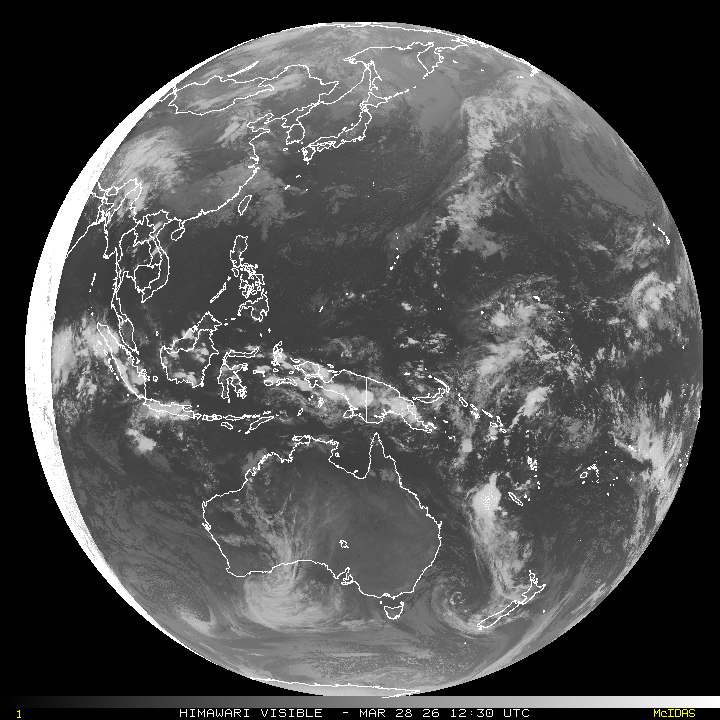
Tropical cyclone 08B (Michaung)…is located approximately 60 NM east-northeast of Chennai, India
Northeast Pacific Ocean:
The North Pacific hurricane season officially ended on November 30, 2023. Routine issuance of the Tropical Weather Outlook will resume on May 15, 2024. During the off-season, Special Tropical Weather Outlooks will be issued as conditions warrant.
The eastern Pacific basin hurricane season was above normal, with 17 named storms, of which 10 were hurricanes and eight of those major hurricanes.
From August 16 to 21, Tropical Storm Hilary brought widespread heavy rainfall and flooding to Southern California, with some areas receiving up to 600% of their normal August rainfall. Hilary resulted in the first ever issuance of Tropical Storm Watches and Warnings for the Southern California coastline by NOAA’s National Hurricane Center. In addition, the Center distributed key hazard focused messages for Hilary in Spanish through the agency’s new language translation project.
Hurricane Otis made landfall near Acapulco, Mexico, on October 25 as a category-5 hurricane, with sustained winds of 165 mph. Otis holds the record as the strongest landfalling hurricane in the eastern Pacific, after undergoing rapid intensification in which wind speeds increased by 115 mph in 24 hours.
Central North Pacific:
The central North Pacific hurricane season officially ended on November 30, 2023. Routine issuance of the Tropical Weather Outlook will resume on June 1, 2024. During the off-season, Special Tropical Weather Outlooks will be issued as conditions warrant.
The central Pacific basin had a near-normal season with four tropical systems traversing the basin.
Hurricane Dora, a category-4 storm, passed south of Hawaii in early August, marking the first major hurricane in the central Pacific basin since 2020. The strong gradient between a high pressure system to the north and Dora to the south was a contributing factor to the wind-driven, fast-moving wildfires in Hawaii.
Western Pacific, Indian Ocean and adjacent Seas:
North Indian Ocean
Tropical cyclone 08B (Michaung)
Animated enhanced infrared satellite imagery depicts a consolidating tropical storm strength circulation with flaring convection partially obscuring the low level circulation center (llcc) and deep convective banding features to the north and west struggling to maintain cohesion as they pass over mainland India. A microwave image shows a partially exposed llcc with fragmented deep convective banding features wrapping the northern semicircle while low level cloud lines can be seen around the llcc. A partial scatterometery pass reveals a slightly elongated circulation with a belt of 35-40 knot winds to the northwest of the llcc.
Tropical cyclone 08B (Michaung) is forecast to continue its gradual march towards southeastern India in a favorable environment. over the next 24 hours, fueled by low vertical wind shear, warm sea surface temperatures and strong outflow aloft, 08B
is forecast to intensify to roughly 60 knots.
As the system approaches the axis of the southern ridge, it will begin to turn due north and just after 36 hours, the system will make landfall over southeastern India near 55 knots. Near 48 hours, as 08B continues inland, vertical wind shear begins to increase and 08B weakens to around 40 knots.
After 48 hours, topography becomes a major obstacle as the system attempts to traverse the eastern Ghats, which further weakens the system and results in its eventual dissipation by 72 hours.
Southwest Pacific Ocean…
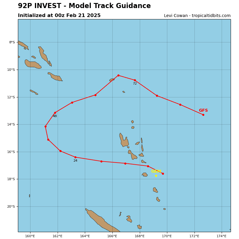
An area of disturbed weather, being referred to as Invest 92P…located approximately 80 NM northeast of Honiara, Guadalcanal, is under investigation by the Joint Typhoon Warning Center (JTWC).
Animated multi-spectral satellite imagery and a microwave image depict a broad, partially exposed low-level circulation center with disorganized flaring convection over the area.
Environmental analysis indicates that 92P is in a favorable environment for development with good outflow aloft, low (10-15 knot) vertical wind shear, and warm sea surface temperatures. However, land interaction will hinder development as the system tracks over the Solomon Islands.
Global models are in good agreement that 92P will track westward over the next 48 hours and continue to develop.
Maximum sustained surface winds are estimated at 15 to 20 knots.
The potential for the development of a significant tropical cyclone within the next 24 hours remains medium.
