

")
Invest 95W / Invest 96W / Invest 91P
Saturday, November 11, 2023
Current Snapshot
For all the latest updates visit: DisasterAWARE

1800×1080

PDC3

95W_tracks_latest

96W_tracks_latest
91P_tracks_latest
By PDC’s Senior Weather
Specialist Glenn James

The Pacific Disaster Center’s (PDC Global) Saturday, November 11, 2023, Tropical Cyclone Activity Report…for the Pacific Ocean, the Indian Ocean, and adjacent Seas
Current Tropical Cyclones:
There are no Tropical Cyclones
Northeast Pacific Ocean:
There are no tropical cyclones, nor any areas of disturbed weather under investigation by the National Hurricane Center (NHC) at the time of this writing.
Central North Pacific:
There are no tropical cyclones, nor any areas of disturbed weather under investigation by the Central Pacific Hurricane Center (CPHC) at the time of this writing.
Western Pacific, Indian Ocean and adjacent Seas:
Western Pacific…
There’s an area of disturbed weather being referred to as Invest 95W…which is located approximately 505 NM south-southeast of Guam
Animated multi-spectral satellite imagery depicts an exposed and broad low-level circulation center (llcc) with disorganized, intermittent convection in the western periphery. Formative shallow banding is observed wrapping into the llcc in a visible 1km image.
Environmental analysis indicates that 95W is in a favorable environment for development with easterly diffluent outflow aloft, low to medium (5-15 knot) vertical wind shear, and warm sea surface temperatures.
Global models agree that 95W will be quasi-stationary as it slowly develops over the next 48 hours.
Maximum sustained surface winds are estimated at 15 to 20 knots.
The potential for the development of a significant tropical cyclone within the next 24 hours remains low.
There’s a second area of disturbed weather being referred to as Invest 96W…which is located approximately 207 NM east of Kosrae
Animated enhanced infrared imagery and a himawari-9 visible image depict a broad area of turning with formative shallow bands of convection wrapping into a consolidating llcc.
Environmental analysis indicates 96W is in a favorable environment for development with good upper-level divergence and high sea surface temperatures (30-31 c), offset by moderate to high vertical wind shear (20-30 knots).
Global numerical model guidance is in fair agreement that 96W will continue to consolidate and further develop as it tracks west-northwestward over the next 48 hours.
Maximum sustained surface winds are estimated at 18 to 22 knots.
The potential for the development of a significant tropical cyclone within the next 24 hours is low.
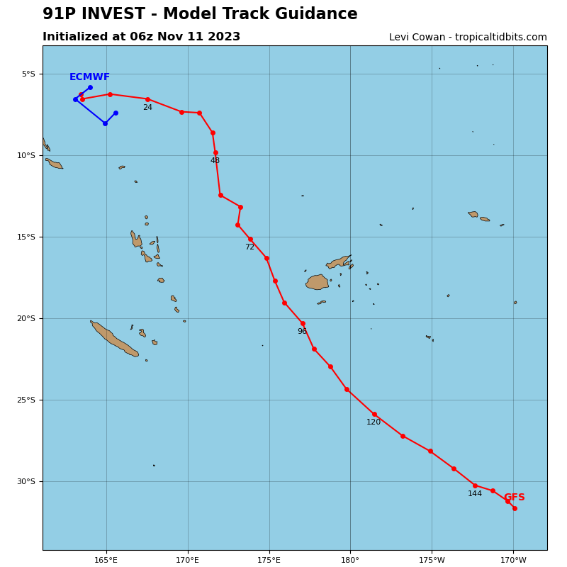
There’s a third area of disturbed weather being referred to as Invest 91P…which is located approximately 224 NM north-northeast of Nendo, Solomon Islands
Animated enhanced infrared imagery and a microwave image depict a broad area of turning with strong poleward outflow evidenced by continuous streams of cirrus filaments drifting southward aloft. Flaring convection has persisted around the periphery of the llcc over the last 12 hours.
Environmental analysis indicates 91P is in a favorable environment for development with exceptional upper-level divergence and high sea surface temperatures, offset by moderate vertical wind shear (15-25 knot).
Global numerical model guidance is in good agreement that 91P will continue to consolidate and further develop as it tracks south- southeastward over the next 48 hours.
Maximum sustained surface winds are estimated at 18 to 22 knots.
The potential for the development of a significant tropical cyclone within the next 24 hours is low.
