

")
Tropical Cyclone 17W / Tropical Cyclone 02P (Mal) / Invest 97W
Tuesday, November 14, 2023
Current Snapshot
For all the latest updates visit: DisasterAWARE

1800×1080

pdc17W

tsat17

17W_tracks_latest

pdcmal

close

jtwcmal

02P_tracks_latest

pdc97w

tsat97w
97W_tracks_latest
By PDC’s Senior Weather
Specialist Glenn James

The Pacific Disaster Center’s (PDC Global) Tuesday, November 14, 2023, Tropical Cyclone Activity Report…for the Pacific Ocean, the Indian Ocean, and adjacent Seas
Current Tropical Cyclones:
Tropical Cyclone 17W…is located approximately 398 NM east-southeast of Koror – Final Warning
Tropical Cyclone 02P (Mal)…is located approximately 134 NM south of Suva, Fiji
Northeast Pacific Ocean:
There are no tropical cyclones, nor any areas of disturbed weather under investigation by the National Hurricane Center (NHC) at the time of this writing.
Central North Pacific:
There are no tropical cyclones, nor any areas of disturbed weather under investigation by the Central Pacific Hurricane Center (CPHC) at the time of this writing.
Western Pacific, Indian Ocean and adjacent Seas:
Tropical Cyclone 17W – Final Warning
According to the JTWC warning number 6
Sustained winds were 20 knots…with gusts to 30 knots
Animated enhanced infrared satellite imagery shows a ragged, weak, and fully exposed low level circulation drifting equatorward and detached 200 NM south-southeastward from the main convection.
Analysis indicates the system has dissipated mainly due to strong vertical wind shear.
Tropical Cyclone 02P (Mal)
According to the JTWC warning number 9
Sustained winds were 75 knots…with gusts to 90 knots
Tropical cyclone 02P remains situated under a belt of moderate upper-level northwesterlies, which is exerting pressure on the northern periphery of the system. Despite this pressure, the system appeared to be consolidating, with a more symmetric central dense overcast (cdo) and colder cloud top temperatures.
However animated enhanced infrared satellite imagery revealed a quickly fragmenting, more asymmetric appearance with warming cloud top
temperatures. This rapid cycling of core convection is expected to continue through 12 hours, aided by robust poleward outflow and warm sea surface temperatures.
TC 02P is forecast to track south-southeastward along the southwestern periphery of the ridge through 36 hours. The system should maintain intensity at 65 knots but could possibly intensify slightly higher through 12 hours due to enhanced poleward outflow into the subtropical jet.
From 12 to 36 hours, vertical wind shear (vws) will increase to high levels (30-55 knots), which will lead to a steady weakening trend. As the system recurves around the ridge after 36 hours, vws will increase to 65 knots as the system begins to interact with the subtropical jet (stj) and commences subtropical transition (stt). STT will complete between 48 and 72 hours as the system interacts with a weak baroclinic zone and tracks under the stj.
>>> Western Pacific…
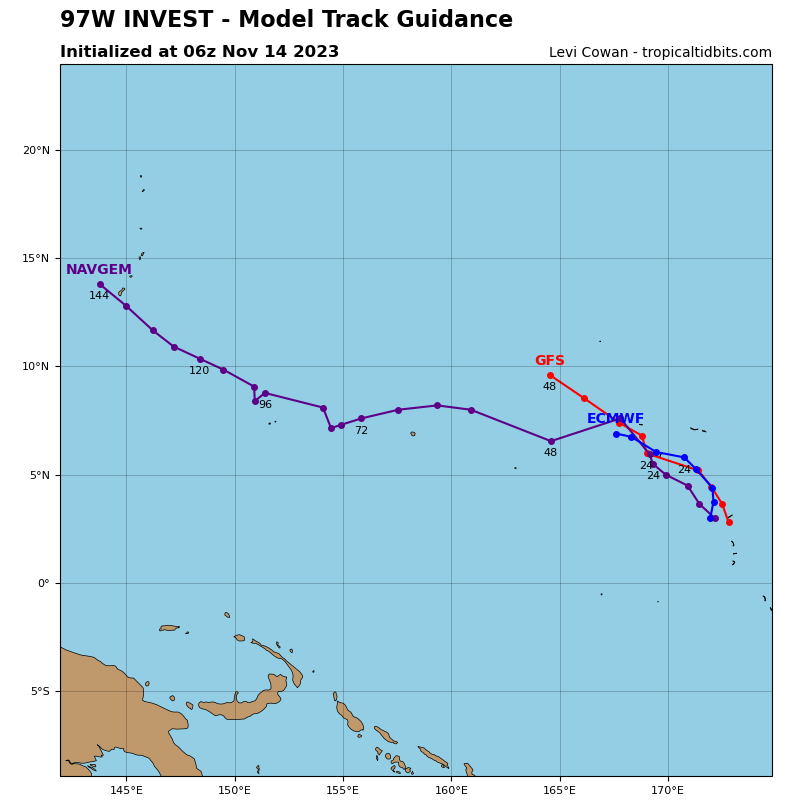
There’s an area of disturbed weather being referred to as Invest 97W…which is located approximately 362 NM south-southeast of Kawajalein
Enhanced infrared satellite imagery and a microwave image depict a broad and disorganized low-level circulation with deep convective bursts along the northern periphery with a larger mass of convection displaced to the southeast. However, another image reveals a defined elongated circulation with 10-15 knot winds.
Environmental analysis indicates that 97W is in a marginally favorable
environment for development with low (10-15 knot) vertical wind shear
and warm sea surface temperatures offset by weak outflow aloft.
Global models agree that 97W will track in a generally west-
northwestward direction but disagree on intensification. The GFS is the
most aggressive model while ECMWF shows considerably less development.
Maximum sustained surface winds are estimated at 12 to 17 knots.
The potential for the development of a significant tropical cyclone within the next 24 hours is low.
