

")
Tropical Cyclone 02P (Mal) / Remnants of 17W / Invest 97W / Invest 94B
Wednesday, November 15, 2023
Current Snapshot
For all the latest updates visit: DisasterAWARE

1800×1080

pdcmal

jtwcmal

tsatmal

02P_tracks_latest

pdc97W
tsat97w

97W_tracks_latest

remants of 17W

tsat17w

17W_tracks_latest

pdc94B

tsat94b

94B_tracks_latest
By PDC’s Senior Weather
Specialist Glenn James

The Pacific Disaster Center’s (PDC Global) Wednesday, November 15, 2023, Tropical Cyclone Activity Report…for the Pacific Ocean, the Indian Ocean, and adjacent Seas
Current Tropical Cyclones:
Tropical Cyclone 02P (Mal)…is located approximately 346 NM south of Suva, Fiji
Northeast Pacific Ocean:
There are no tropical cyclones, nor any areas of disturbed weather under investigation by the National Hurricane Center (NHC) at the time of this writing.
Central North Pacific:
There are no tropical cyclones, nor any areas of disturbed weather under investigation by the Central Pacific Hurricane Center (CPHC) at the time of this writing.
Western Pacific, Indian Ocean and adjacent Seas:
Southwestern Pacific
Tropical Cyclone 02P (Mal)
According to the JTWC warning number 12
Sustained winds were 55 knots…with gusts to 70 knots
Animated enhanced infrared (eir) satellite imagery depicts a broad, exposed low-level circulation center with rapidly deteriorating deep convection sheared to the southeast. EIR also shows extensive stratocumulus advecting northward over the western semicircle, associated with a cooler, drier, more stable airmass.
TC 02P has commenced subtropical transition (stt) and is forecast to track south-southeastward to southeastward into an increasingly hostile environment, with rapid weakening anticipated due to very high (70-80 knots after 24 hours) vertical wind shear, dry air entrainment and cooling sea surface temperature values. TC 02P will complete stt near 24 hours as it tracks under the subtropical jet.
Western Pacific…
There’s an area of disturbed weather being referred to as Invest 97W…which is located approximately 235 NM south of Kawajalein
Animated multi-spectral satellite imagery depicts a broad area of low-level turning with scattered convection covering the area.
Environmental analysis indicates that 97w is in a favorable environment for development with good equatorward outflow aloft, low (10-15 knot) vertical wind shear, and warm sea surface temperatures.
Global models are in good agreement that 97W will track in a west-northwestward direction, but disagree on intensification. GFS is aggressive while ECMWF shows considerably less development for the system.
Maximum sustained surface winds are estimated at 12 to 17 knots.
The potential for the development of a significant tropical cyclone within the next 24 hours remains low.
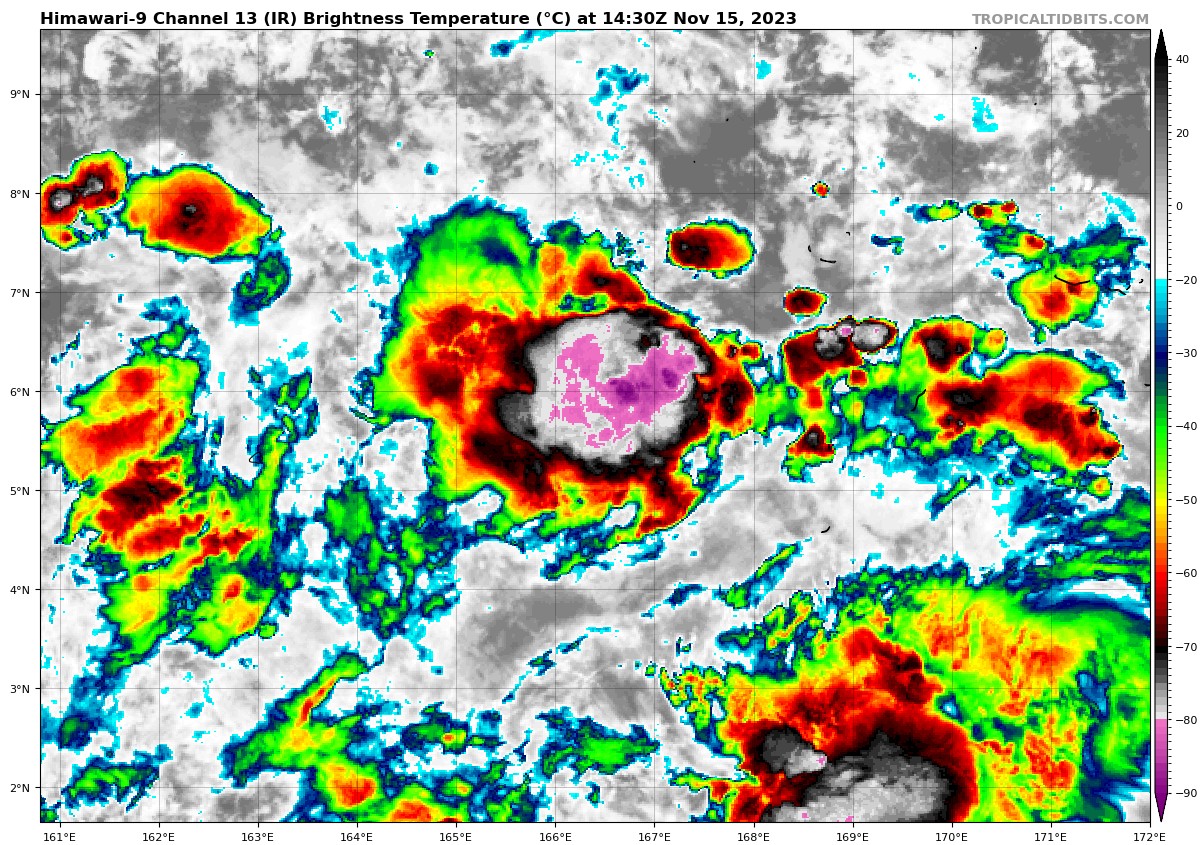
There’s a second area of disturbed weather being referred to as the remnants of 17W…which is located approximately 277 NM east-southeast of Palau
Animated multi-spectral satellite imagery depicts an exposed, elongated low-level circulation (llc) accompanied by disorganized convection.
Environmental analysis indicates that the system is in a marginally favorable environment for development with good outflow aloft and warm sea surface temperatures offset by high (25-30 knot) vertical wind shear.
Global models are in good agreement that the system will track in a west-northwestward direction with gradual development over the next 48-72 hours.
Maximum sustained surface winds are estimated at 12 to 17 knots.
The potential for the development of a significant tropical cyclone within the next 24 hours is low.
There’s a third area of disturbed weather being referred to as Invest 94B…which is located approximately 87 NM southeast of Visakhapatnam, India
Animated multi-spectral satellite imagery and a microwave image depict a partially exposed low-level circulation center (llcc) with flaring convection in the northeastern semicircle beginning to wrap into the llcc.
Environmental analysis indicates that 94B is in a favorable environment for development with robust poleward outflow aloft, low (10-15 knot) vertical wind shear, and warm sea surface temperatures.
Global models are in good agreement that 94B will track north-northeastward and continue to develop over the next 48 hours.
Maximum sustained surface winds are estimated at 23 to 28 knots.
The potential for the development of a significant tropical cyclone within the next 24 hours is medium.
