Current Snapshot
For all the latest updates visit: DisasterAWARE
By PDC’s Senior Weather
Specialist Glenn James

The Pacific Disaster Center’s (PDC Global) Thursday, May 16, 2024, Tropical Cyclone Activity Report…for the Pacific Ocean, the Indian Ocean, and adjacent Seas
Current Tropical Cyclones:
Tropical Cyclone 24S (Laly) is located approximately 641 NM north-northeast of Antananarivo, Madagascar
Northeast Pacific Ocean:
South of the coast of southwestern Mexico
>>> A small area of low pressure is located several hundred miles offshore of the coast of southwestern Mexico. Shower and thunderstorm activity has become a little more concentrated near the low tonight, and recent satellite wind data suggests the center is embedded in the convection. While environmental conditions appear only marginally favorable due to nearby dry air, some additional development of this system is possible during the next day or so as the low drifts slowly. By this weekend, the low is forecast to interact or merge with another system to its east.
* Formation chance through 48 hours…low…30 percent
* Formation chance through 7 days…low…30 percent
South of the coast of southern Mexico
>>> A broad area of low pressure is forecast to form several hundred miles to the south of southern Mexico during the next day or two. Some gradual development of this system is possible thereafter as it moves slowly to the west or west-northwest, remaining south of the coast of Mexico by the middle portion of next week.
* Formation chance through 48 hours…low…near 0 percent
* Formation chance through 7 days…low…30 percent
Central North Pacific:
The central North Pacific hurricane season officially ended on November 30, 2023. Routine issuance of the Tropical Weather Outlook will resume on June 1, 2024. During the off-season, Special Tropical Weather Outlooks will be issued as conditions warrant.
The central Pacific basin had a near-normal season with four tropical systems traversing the basin.
Hurricane Dora, a category-4 storm, passed south of Hawaii in early August, marking the first major hurricane in the central Pacific basin since 2020. The strong gradient between a high pressure system to the north and Dora to the south was a contributing factor to the wind-driven, fast-moving wildfires in Hawaii.
Western Pacific, Indian Ocean and adjacent Seas
South Indian Ocean
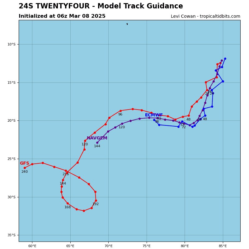
Tropical Cyclone 24S (Laly)
According to the JTWC Warning number 2…sustained winds were 40 knots, with gusts to near 50 knots
Animated multi-spectral satellite (msi) imagery depicts tropical cyclone 24S (Laly) consolidating with significant deep convective banding to the south and west wrapping into the low-level circulation center (llcc). The system is currently being steered to the southwest on the periphery of a subtropical ridge (str) to the south. Another image highlighted the asymmetrical nature of the wind field, conveying wind speeds as weak as 15-20 knots on the northeastern periphery of the system and elevated speeds exceeding warning criteria to the southwest.
Environmental conditions are favorable given the moderate poleward outflow, warm sea surface temperatures, and moderate vertical wind shear of 10-15 knots. The initial position was assessed with medium confidence based on animated msi, depicting deep convective banding from the southwest wrapping in to the llcc.
Tropical cyclone 24S is forecast to continue tracking westward slowly over the next 48 hours on the northern periphery of a str to the south. Beyond 48 hours, the system is forecast to track in a northward direction under the steering influence of a near equatorial ridge located over the central
African continent.
In the near-term, TC 24S will intensify through the first 72 hours due to generally favorable conditions of low to moderate vertical wind shear, warm sea surface temperatures, and moderate poleward outflow, overcoming asymmetry of the current wind field.
However, between 72 and 120 hours mid- and upper-level vertical wind shear is expected to decapitate the system, resulting in full dissipation by the end of the forecast period. Dry air entrainment will ensue, accompanied by a reduction of outflow as significant straight-line upper-level flow will create an unfavorable environment.


