

")
Tropical Cyclone 20S
Monday, March 25, 2024
Current Snapshot
For all the latest updates visit: DisasterAWARE

10
pdc20s

20S_260000sair

meteosat9_ir_20S_202403260521_lat-12.6-lon50.9

20S_tracks_latest
By PDC’s Senior Weather
Specialist Glenn James

The Pacific Disaster Center’s (PDC Global) Monday, March 25, 2024, Tropical Cyclone Activity Report…for the Pacific Ocean, the Indian Ocean, and adjacent Seas
Current Tropical Cyclones:
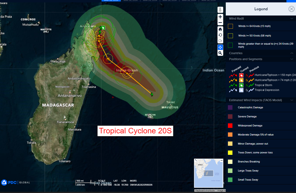
Tropical Cyclone 20S…is located approximately 418 NM north-northwest of Antananarivo, Madagascar
Northeast Pacific Ocean:
The North Pacific hurricane season officially ended on November 30, 2023. Routine issuance of the Tropical Weather Outlook will resume on May 15, 2024. During the off-season, Special Tropical Weather Outlooks will be issued as conditions warrant.
The eastern Pacific basin hurricane season was above normal, with 17 named storms, of which 10 were hurricanes and eight of those major hurricanes.
From August 16 to 21, Tropical Storm Hilary brought widespread heavy rainfall and flooding to Southern California, with some areas receiving up to 600% of their normal August rainfall. Hilary resulted in the first ever issuance of Tropical Storm Watches and Warnings for the Southern California coastline by NOAA’s National Hurricane Center. In addition, the Center distributed key hazard focused messages for Hilary in Spanish through the agency’s new language translation project.
Hurricane Otis made landfall near Acapulco, Mexico, on October 25 as a category-5 hurricane, with sustained winds of 165 mph. Otis holds the record as the strongest land falling hurricane in the eastern Pacific, after undergoing rapid intensification in which wind speeds increased by 115 mph in 24 hours.
Central North Pacific:
The central North Pacific hurricane season officially ended on November 30, 2023. Routine issuance of the Tropical Weather Outlook will resume on June 1, 2024. During the off-season, Special Tropical Weather Outlooks will be issued as conditions warrant.
The central Pacific basin had a near-normal season with four tropical systems traversing the basin.
Hurricane Dora, a category-4 storm, passed south of Hawaii in early August, marking the first major hurricane in the central Pacific basin since 2020. The strong gradient between a high pressure system to the north and Dora to the south was a contributing factor to the wind-driven, fast-moving wildfires in Hawaii.
Western Pacific, Indian Ocean and adjacent Seas
South Indian Ocean…
Tropical Cyclone 20S
According to the JTWC warning number 1, sustained winds are 35 knots…with gusts to near 45 knots
Animated enhanced infrared satellite imagery depicts tropical cyclone 20S nearly quasi-stationary in a competing steering environment caught at a near standstill between a near equatorial ridge (ner) to the east, west, and north.
Persistent convection is beginning to consolidate into an upper-level microwave eye-like structure. However, the low-level is completely obscured and unable to be identified.
At the upper-levels, an anticyclone has developed over the system with the subtropical jet stream to the south encouraging a strong poleward outflow channel. Minimal vertical wind shear of 5-10 knots and warm sea surface temperatures create a positively favorable environment for intensification.
