

")
Invest 95P
Sunday, February 4, 2024
Current Snapshot
For all the latest updates visit: DisasterAWARE
10
pdc95P
goes18_ir_95P_202402041515_lat-14.9-lon-170.4
95P_tracks_latest
By PDC’s Senior Weather
Specialist Glenn James

The Pacific Disaster Center’s (PDC Global) Sunday, February 4, 2024, Tropical Cyclone Activity Report…for the Pacific Ocean, the Indian Ocean, and adjacent Seas
Current Tropical Cyclones:
There are no active tropical cyclones
Northeast Pacific Ocean:
The North Pacific hurricane season officially ended on November 30, 2023. Routine issuance of the Tropical Weather Outlook will resume on May 15, 2024. During the off-season, Special Tropical Weather Outlooks will be issued as conditions warrant.
The eastern Pacific basin hurricane season was above normal, with 17 named storms, of which 10 were hurricanes and eight of those major hurricanes.
From August 16 to 21, Tropical Storm Hilary brought widespread heavy rainfall and flooding to Southern California, with some areas receiving up to 600% of their normal August rainfall. Hilary resulted in the first ever issuance of Tropical Storm Watches and Warnings for the Southern California coastline by NOAA’s National Hurricane Center. In addition, the Center distributed key hazard focused messages for Hilary in Spanish through the agency’s new language translation project.
Hurricane Otis made landfall near Acapulco, Mexico, on October 25 as a category-5 hurricane, with sustained winds of 165 mph. Otis holds the record as the strongest land falling hurricane in the eastern Pacific, after undergoing rapid intensification in which wind speeds increased by 115 mph in 24 hours.
Central North Pacific:
The central North Pacific hurricane season officially ended on November 30, 2023. Routine issuance of the Tropical Weather Outlook will resume on June 1, 2024. During the off-season, Special Tropical Weather Outlooks will be issued as conditions warrant.
The central Pacific basin had a near-normal season with four tropical systems traversing the basin.
Hurricane Dora, a category-4 storm, passed south of Hawaii in early August, marking the first major hurricane in the central Pacific basin since 2020. The strong gradient between a high pressure system to the north and Dora to the south was a contributing factor to the wind-driven, fast-moving wildfires in Hawaii.
Western Pacific, Indian Ocean and adjacent Seas:
Southwestern Pacific Ocean…
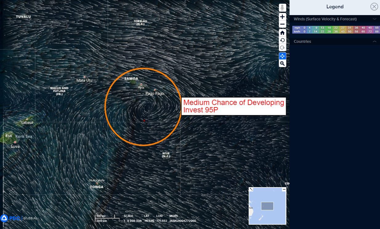
>>> There’s an area of disturbed weather being referred to as Invest 95P…which is located approximately 105 NM west-southwest of Pago Pago, American Samoa
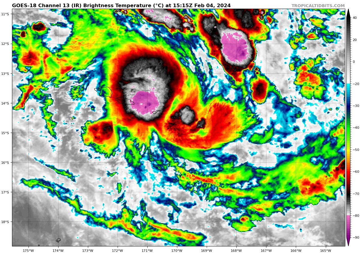
Animated multi-spectral satellite imagery shows that while the low level circulation remains rather broad, it is consolidating quickly, primarily focused in the northern portion of the larger circulation. Deep convection has persisted over and north of the perceived low level circulation center (llcc), enhanced by a line of low-level convergence. Invest 95P is more tropical in nature now, which is validated by the current upper-level analysis.
Environmental conditions prove to be favorable for further development characterized by good poleward outflow aloft (aided by a point source to the northeast), low to moderate (15-20 knot) vertical wind shear, and warm sea surface temperatures.
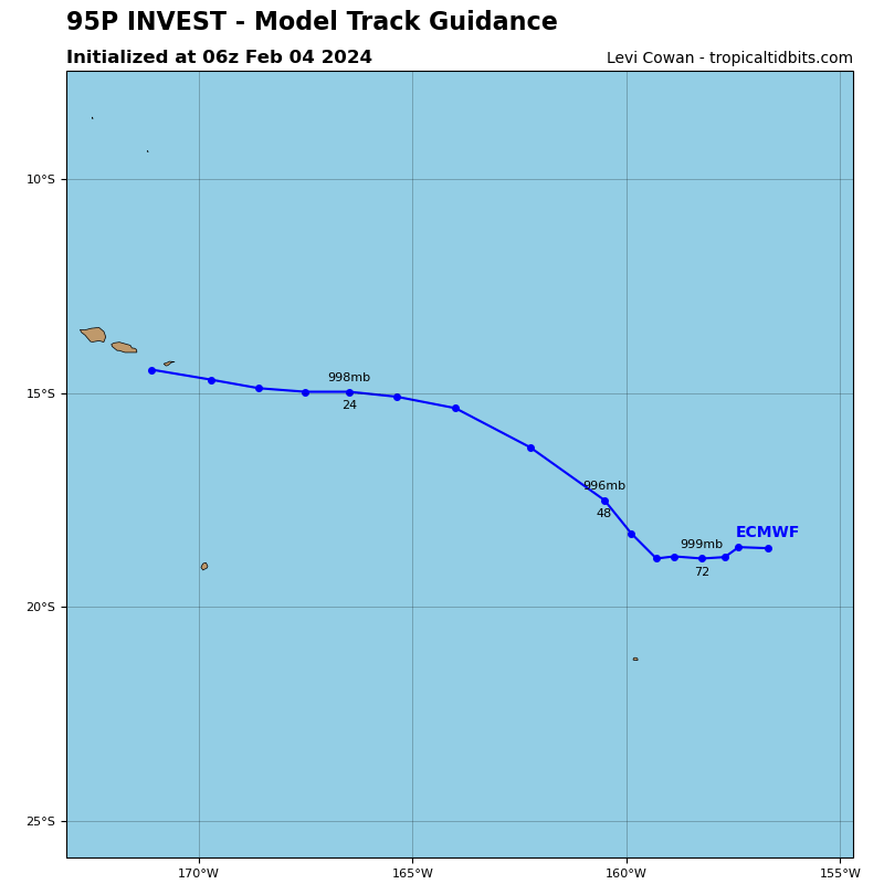
Global numerical model guidance indicates that the GFS model, with its usual forward leaning calculations has initialized the best concerning development of this system. The overall model consensus agrees invest 95P will continue on a east-northeastward track in the near-term, then quickly flatten out to a eastward track, remaining south of American Samoa, then by 24 hours make an east-southeastward turn generally towards French Polynesia.
Gradual intensification is anticipated over the next 24 to 48 hours as the system slides east of American Samoa and continues to consolidate. Intensity guidance shows the system struggling to get past 25 knots with a peak of 30 knots. Though intensity guidance does not like the system as much, it is still a sleeper that should not be over looked.
Maximum sustained surface winds are estimated at 18 to 23 knots.
The potential for the development of a significant tropical cyclone within the next 24 hours is upgraded to medium.
