

")
Invest 90S
Sunday, March 3, 2024
Current Snapshot
For all the latest updates visit: DisasterAWARE

10

pdc90s

meteosat9_ir_90S_202403031521_lat-12.2-lon49.5
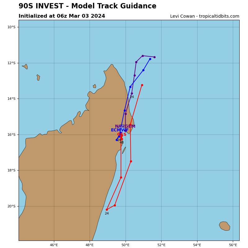
90S_tracks_latest
By PDC’s Senior Weather
Specialist Glenn James

The Pacific Disaster Center’s (PDC Global) Sunday, March 3, 2024, Tropical Cyclone Activity Report…for the Pacific Ocean, the Indian Ocean, and adjacent Seas
Current Tropical Cyclones:
There are no Tropical Cyclones…although there’s an area of disturbed weather being referred to as Invest 90S in the South Indian Ocean
Northeast Pacific Ocean:
The North Pacific hurricane season officially ended on November 30, 2023. Routine issuance of the Tropical Weather Outlook will resume on May 15, 2024. During the off-season, Special Tropical Weather Outlooks will be issued as conditions warrant.
The eastern Pacific basin hurricane season was above normal, with 17 named storms, of which 10 were hurricanes and eight of those major hurricanes.
From August 16 to 21, Tropical Storm Hilary brought widespread heavy rainfall and flooding to Southern California, with some areas receiving up to 600% of their normal August rainfall. Hilary resulted in the first ever issuance of Tropical Storm Watches and Warnings for the Southern California coastline by NOAA’s National Hurricane Center. In addition, the Center distributed key hazard focused messages for Hilary in Spanish through the agency’s new language translation project.
Hurricane Otis made landfall near Acapulco, Mexico, on October 25 as a category-5 hurricane, with sustained winds of 165 mph. Otis holds the record as the strongest land falling hurricane in the eastern Pacific, after undergoing rapid intensification in which wind speeds increased by 115 mph in 24 hours.
Central North Pacific:
The central North Pacific hurricane season officially ended on November 30, 2023. Routine issuance of the Tropical Weather Outlook will resume on June 1, 2024. During the off-season, Special Tropical Weather Outlooks will be issued as conditions warrant.
The central Pacific basin had a near-normal season with four tropical systems traversing the basin.
Hurricane Dora, a category-4 storm, passed south of Hawaii in early August, marking the first major hurricane in the central Pacific basin since 2020. The strong gradient between a high pressure system to the north and Dora to the south was a contributing factor to the wind-driven, fast-moving wildfires in Hawaii.
Western Pacific, Indian Ocean and adjacent Seas
>>> There’s an area of disturbed weather being referred to as the Invest 90S…which is located approximately 362 NM east of Comoros.
Animated multi-spectral satellite imagery (msi) and a microwave image depict an disorganized low level circulation (llc) with flaring convection to the southern periphery of the system.
Environmental analysis reveals a marginally favorable environment for further development of invest 90S with low to moderate (15-20kts) vertical wind shear, good poleward outflow, and warm sea surface temperatures, offset by frictional effects and disruption of the low-level flow due to land interaction as the circulation passes over northern Madagascar.
Global deterministic models are in good agreement that 90S will continue on a southwestward track while transiting over the northern tip of Madagascar and continuing into the Mozambique Channel. however, the most recent model run exhibits strong disagreement on the potential development of the system.
The previous ECMWF run was quite bullish about bringing the system to tropical cyclone strength as it moved in the channel, but the most recent run shows little in the way of development. The GFS continues to show slow but steady consolidation and then intensification into a tropical cyclone in the longer term, in the southern portion of the channel. The discontinuity in the model guidance introduces a high amount of uncertainty into the forecast over the next several days.
Maximum sustained surface winds are estimated at 23 to 27 knots.
The potential for the development of a significant tropical cyclone within the next 24 hours remains low.
