

")
Invest 90S / Invest 93S
Tuesday, February 13, 2024
Current Snapshot
For all the latest updates visit: DisasterAWARE

uuu

pdc90s

j
90S_tracks_latest

himawari9_ir_93S_202402131520_lat-14.1-lon134.5
93S_tracks_latest
By PDC’s Senior Weather
Specialist Glenn James

The Pacific Disaster Center’s (PDC Global) Tuesday, February 13, 2024, Tropical Cyclone Activity Report…for the Pacific Ocean, the Indian Ocean, and adjacent Seas
Current Tropical Cyclones:
There are no active Tropical Cyclones
Northeast Pacific Ocean:
The North Pacific hurricane season officially ended on November 30, 2023. Routine issuance of the Tropical Weather Outlook will resume on May 15, 2024. During the off-season, Special Tropical Weather Outlooks will be issued as conditions warrant.
The eastern Pacific basin hurricane season was above normal, with 17 named storms, of which 10 were hurricanes and eight of those major hurricanes.
From August 16 to 21, Tropical Storm Hilary brought widespread heavy rainfall and flooding to Southern California, with some areas receiving up to 600% of their normal August rainfall. Hilary resulted in the first ever issuance of Tropical Storm Watches and Warnings for the Southern California coastline by NOAA’s National Hurricane Center. In addition, the Center distributed key hazard focused messages for Hilary in Spanish through the agency’s new language translation project.
Hurricane Otis made landfall near Acapulco, Mexico, on October 25 as a category-5 hurricane, with sustained winds of 165 mph. Otis holds the record as the strongest land falling hurricane in the eastern Pacific, after undergoing rapid intensification in which wind speeds increased by 115 mph in 24 hours.
Central North Pacific:
The central North Pacific hurricane season officially ended on November 30, 2023. Routine issuance of the Tropical Weather Outlook will resume on June 1, 2024. During the off-season, Special Tropical Weather Outlooks will be issued as conditions warrant.
The central Pacific basin had a near-normal season with four tropical systems traversing the basin.
Hurricane Dora, a category-4 storm, passed south of Hawaii in early August, marking the first major hurricane in the central Pacific basin since 2020. The strong gradient between a high pressure system to the north and Dora to the south was a contributing factor to the wind-driven, fast-moving wildfires in Hawaii.
Western Pacific, Indian Ocean and adjacent Seas:
South Indian Ocean…
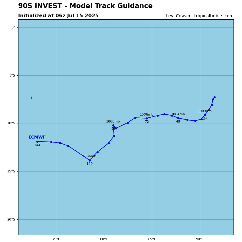
There’s an area of disturbed weather, being referred to as Invest 90S…located approximately 531 NM southwest of Diego Garcia.
Animated multi-spectral satellite imagery depicts a fairly small partially exposed low level circulation center with deep convection flaring on the eastern periphery of the system.
Environmental analysis reveals favorable conditions for further development of invest 90S with good poleward outflow aloft, low (10-15 knot) vertical wind shear, and warm sea surface temperatures.
Global models are in general agreement that 90S will continue on an eastward track through the subsident environment to finally get more of a chimney effect going in its favor beyond 72 hours, and consolidate and strengthen more.
Maximum sustained surface winds are estimated at 18 to 23 knots.
The potential for the development of a significant tropical cyclone within the next 24 hours is low.
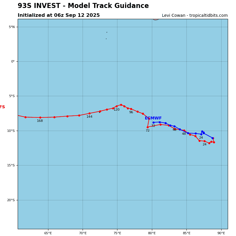
There’s a second area of disturbed weather, being referred to as Invest 93S…located approximately 145 NM west-northwest of Mornington Island, Australia
Animated multi-spectral satellite imagery depicts an elongated low level circulation with persistent deep flaring convection.
Environmental analysis reveals a favorable environment for cyclogenesis with warm sea surface temperatures, moderate equatorward divergence aloft, and low (5-10 knot) vertical wind shear.
Global models are in good agreement that 93S will generally track eastward then turn southward or southwestward while gradually developing within the Gulf of Carpentaria during the next 24-36 hours.
Mesoscale guidance is also in good agreement that invest 93S will intensify near warning criteria over the next 36-48 hours prior to potentially moving back inland.
Maximum sustained surface winds are estimated at 23 to 28 knots.
The potential for the development of a significant tropical cyclone within the next 24 hours is upgraded to medium.
