

")
Tropical Cyclone 13S (Djoungou) / Invest 95S / Remnants of 15P
Saturday, February 17, 2024
Current Snapshot
For all the latest updates visit: DisasterAWARE

10

pdcdjoungou

13S_170600sair

meteosat9_ir_13S_202402171551_lat-16.4-lon70.4

13S_tracks_latest
pdc15p

goes18_ir_15P_202402171545_lat-29.3-lon-152.5

15P_tracks_latest
By PDC’s Senior Weather
Specialist Glenn James

The Pacific Disaster Center’s (PDC Global) Saturday, February 17, 2024, Tropical Cyclone Activity Report…for the Pacific Ocean, the Indian Ocean, and adjacent Seas
Current Tropical Cyclones:
Tropical Cyclone 13S (Djoungou)…is located approximately 576 NM south of Diego Garcia
Northeast Pacific Ocean:
The North Pacific hurricane season officially ended on November 30, 2023. Routine issuance of the Tropical Weather Outlook will resume on May 15, 2024. During the off-season, Special Tropical Weather Outlooks will be issued as conditions warrant.
The eastern Pacific basin hurricane season was above normal, with 17 named storms, of which 10 were hurricanes and eight of those major hurricanes.
From August 16 to 21, Tropical Storm Hilary brought widespread heavy rainfall and flooding to Southern California, with some areas receiving up to 600% of their normal August rainfall. Hilary resulted in the first ever issuance of Tropical Storm Watches and Warnings for the Southern California coastline by NOAA’s National Hurricane Center. In addition, the Center distributed key hazard focused messages for Hilary in Spanish through the agency’s new language translation project.
Hurricane Otis made landfall near Acapulco, Mexico, on October 25 as a category-5 hurricane, with sustained winds of 165 mph. Otis holds the record as the strongest land falling hurricane in the eastern Pacific, after undergoing rapid intensification in which wind speeds increased by 115 mph in 24 hours.
Central North Pacific:
The central North Pacific hurricane season officially ended on November 30, 2023. Routine issuance of the Tropical Weather Outlook will resume on June 1, 2024. During the off-season, Special Tropical Weather Outlooks will be issued as conditions warrant.
The central Pacific basin had a near-normal season with four tropical systems traversing the basin.
Hurricane Dora, a category-4 storm, passed south of Hawaii in early August, marking the first major hurricane in the central Pacific basin since 2020. The strong gradient between a high pressure system to the north and Dora to the south was a contributing factor to the wind-driven, fast-moving wildfires in Hawaii.
Western Pacific, Indian Ocean and adjacent Seas
South Indian Ocean…
Tropical Cyclone 13S (Djoungou)
According to the JTWC warning number 5, sustained winds are 100 knots…with gusts to near 125 knots
Animated multi-spectral satellite imagery shows tropical cyclone 13S (Djoungou) exhibiting persistent, centralized deep convection partially obscuring the low level circulation center over the past 12 hours. A microwave image reveals a formative microwave eye closed off in all but the southeastern section with spiral banding wrapping into center of circulation.
Despite the dry air, however, the environment is overall very favorable for intensification to occur with low (0-5 knot) vertical wind shear, warm sea surface temperatures, and exceptional poleward divergence aloft.
TC 13S is forecast to track along the southwestern periphery of a near equatorial ridge throughout the forecast interval. From 00 to 36 hours, the steering influence presented will slowly turn the system from an eastward track to a southeastward track.
During this time, the TC is forecast to undergo rapid intensification in a very favorable environment, peaking between 24 and 36 hours at near 110 knots. Beginning near 36 hours, high (over 30 knot) vertical wind shear, decoupling of upper level divergence support, falling sea surface temperatures, and dry air entrainment of the core vortex (48 to 96 hours) are anticipated to quickly weaken the system.
The TC is forecast to transition to a subtropical system between 72 and 96 hours.
South Indian Ocean…
>>> There’s an area of disturbed weather being referred to as the Invest 95S…which is located approximately 397 NM west-northwest of Mauritius.
Invest 95S will not stop until it gets enough, showing great structural improvement as it has rapidly
consolidated over the past six hours. Animated enhanced infrared satellite imagery and a microwave image depict a low level circulation (llc) with deep flaring convection concentrated over and northeast of the perceived low level circulation center and fragmented banding mainly on the southern periphery of the system.
The environment is highly favorable for further development with low (5-10 knot) vertical wind shear, good poleward outflow aloft, and warm sea surface temperatures.
Environmental analysis reveals unfavorable conditions for tropical transition defined by a deep layer of dry air being advected over the circulation, strong westerlies aloft, high (30 knot) vertical wind shear, and cool sea surface temperatures.
Global deterministic and ensemble models are in tight agreement on the development of invest 95S and tracking it northeastward over the next 24-36 hours, but have differences when it comes to speed of the system as it flattens out on an eastward trajectory.
Intensity guidance shows good consensus on invest 95S tracking over a patch of very warm water within the next 12-24 hours, which will fuel rapid and steady intensification before making a southward turn towards the Mascarene islands.
Maximum sustained surface winds are estimated at 23 to 28 knots.
The potential for the development of a significant tropical cyclone within the next 24 hours is high.
Southwestern Pacific Ocean…
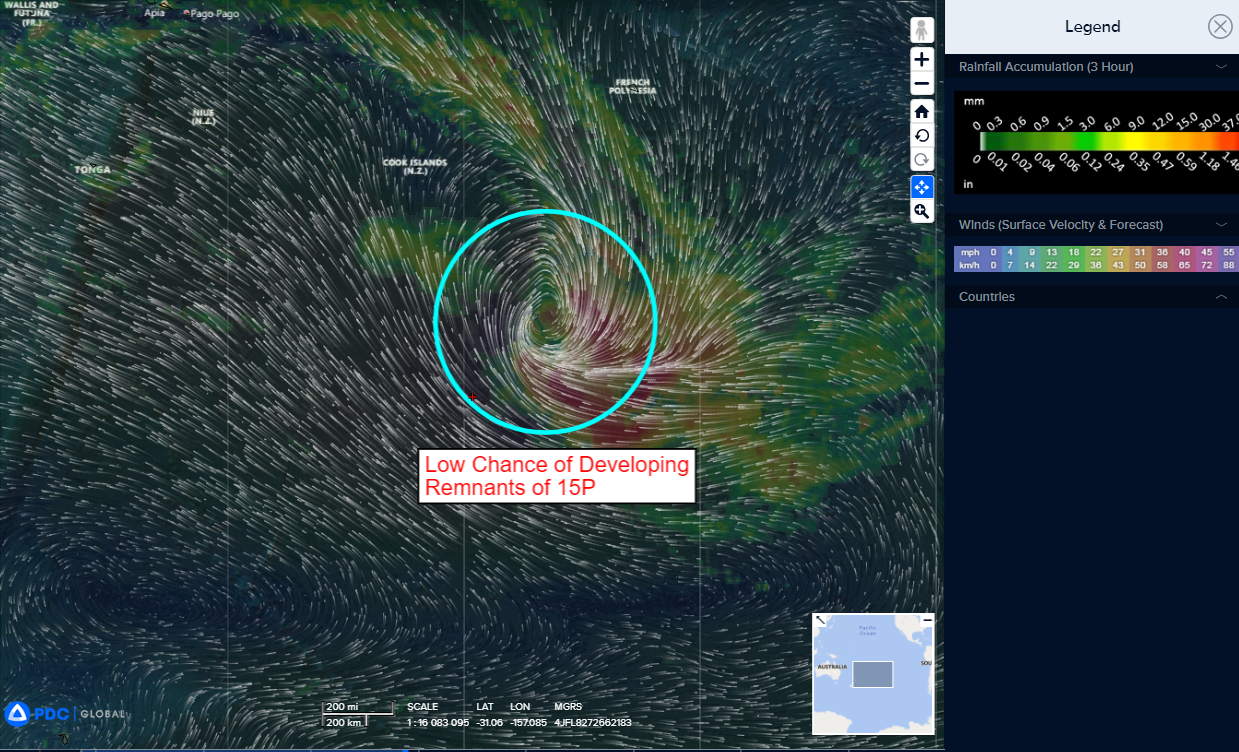
>>> There’s an area of disturbed weather being referred to as the Remnants of 15P…which is located approximately 778 NM south of Bora Bora.
The system is currently classified as a subtropical cyclone, generally characterized as having both tropical and mid-latitude cyclone features.
Animated IR satellite imagery and a microwave image depicts a fully exposed low level circulation center with associated convection offset to the southeast.
Environmental analysis reveals unfavorable conditions for tropical transition defined by a deep layer of dry air being advected over the circulation, strong westerlies aloft, high (30 knot) vertical wind shear, and cool sea surface temperatures.
Global models are in agreement that the remnants of TC 15P will track southeastward with a broad and asymmetric wind field.
Maximum sustained surface winds are estimated at 42 to 48 knots.
The potential for the development of a significant tropical cyclone within the next 24 hours is low.
