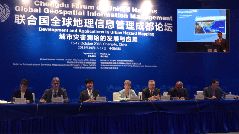
Over 200 officials from nearly 40 countries convened in Chengdu, China, October 15–17, to participate in the Chengdu Forum on the United Nations initiative on Global Geospatial Information Management (UN-GGIM). Organized by the Secretariat of UN-GGIM and the National Administration of Surveying, Mapping and Geoinformation (NASG) of China, the event was themed “Global Map for Sustainable Development: Development and Applications in Urban Hazard Mapping.”
UN-GGIM is taking on a leading role in setting the agenda for the development of global geospatial information and promoting its use to address key global challenges. The forum provided a platform for the discussion of priority issues related to developing, managing, and sharing geospatial information. Additionally, it served to encourage and enable nations to better understand and apply natural hazard impact mapping and analysis in urban environments. Leading experts were engaged to share experiences and methodologies in the production, management, analysis, modeling, and dissemination of hazard-related geospatial information with each other and all participants.
As a sponsored speaker for the special session on Hazard and Risk Modeling Applications, Pacific Disaster Center (PDC) Deputy Executive Director Chris Chiesa presented, “Applied Science and Technology Supporting Risk Assessment, Hazard Monitoring, and Early Warning Around the Globe.” He also chaired the “Developing Geospatial Applications and Methods” session, and served as a panelist during the forum’s closing session.
The experts speaking at the Forum recognized that geospatial information plays a vital role in all phases of hazard and disaster risk management and reduction, and that it extends the ability of nations to map their geography and topography, including areas that are particularly vulnerable to hazards. During the three-day event, PDC’s capabilities, including the Disaster Alert mobile app and the PDC Active Hazard data service, were highlighted and discussed by forum speakers.
For more information on this event:
• Visit the UN-GGIM event site, and
• Read through the UN-GGIM annotated agenda.
ABOUT PDC
Pacific Disaster Center (PDC Global) is a leading scientific innovator in disaster risk reduction science and technology. As a University of Hawai’i applied science and research center, our work intersects with government, community, academic, and scientific organizations at home and around the world to build resilience to natural and man-made hazards. We enable communities to confront disasters more effectively by enhancing the capacity to rapidly anticipate and prepare for new and emerging threats using our AI-powered multi-hazard early warning technology, DisasterAWARE, predictive analytics, data science, and machine learning. For more than 30 years, PDC innovations have equipped decision-makers with the powerful tools and insights they need to navigate today’s complex and interconnected risk landscape.
PDC received prestigious recognition from the United Nations for its international impact in 2022, being granted the once-in-a-lifetime U.N. Sasakawa Award for Disaster Risk Reduction.